
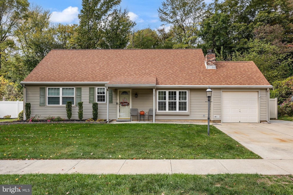
17 Devonshire Dr Westampton, NJ 08060
Estimated payment $3,014/month
Total Views
1,207
4
Beds
3
Baths
1,747
Sq Ft
$269
Price per Sq Ft
Highlights
- Spa
- View of Trees or Woods
- Engineered Wood Flooring
- Rancocas Valley Regional High School Rated A-
- Cape Cod Architecture
- Cathedral Ceiling
About This Home
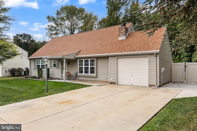
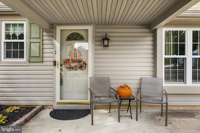
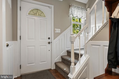
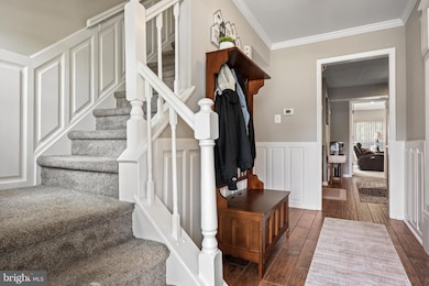
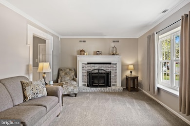
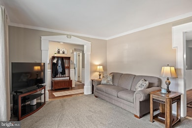
Welcome to this absolutely stunning four-bedroom, two-bath Cape Cod in the desirable Tarnsfield community. From the moment you arrive, you’ll recognize the pride of ownership and attention to detail. With newer vinyl siding, replacement vinyl windows, an architectural roof, and manicured landscaping, the curb appeal is outstanding. A charming front porch with overhang sets the tone for the warm welcome inside. Step into the foyer, where luxury plank tile flooring and custom millwork make a memorable first impression. Wainscoting flows throughout much of the first floor, adding elegance and depth. The living room is anchored by a striking whitewashed fireplace with wood mantle, while intricate woodwork frames the entryways into both the living and dining rooms. The dining room is ideal for casual meals or intimate dinner parties. The remodeled kitchen is a chef’s delight, offering maple cabinetry, granite countertops, stainless steel appliances, decorative backsplash, recessed lighting, and thoughtful features such as a Lazy Susan. There is also a pantry and broom closet. On this level you will find the laundry room which houses the washer, dryer and hvac. From there, step into the oversized family room—a true “wow” factor space—measuring 16x20. This stunning room features a cathedral ceiling and filled with natural light from numerous windows. This inviting room is perfect for gatherings and features a ceiling fan and included light fixtures. The heating is Here's a bonus the Mounted TV is included. From this room you can step onto the patio. The family room is kept comfortable year-round with its own dedicated mini-split system for heating and cooling.
The main level also includes the spacious primary bedroom with ceiling fan, along with a versatile second bedroom ideal for guests or a home office. The main bathroom features a garden tub, Corian-topped vanity, and tasteful finishes. Upstairs, you’ll find two additional bedrooms, each with ceiling fans and included lighting, along with a second full bathroom. Also each bedroom is equipped with a mini split for heating and cooling. Highlighted by a beautiful Palladian window and an oversized sink, The second floor bathroom is highlighted by a beautiful Palladian window and oversized sink.
The backyard, however, is nothing short of sensational. A stamped concrete patio, accented with decorative river rock and artistic patterns, creates a stunning outdoor living space. Relax in the hot tub (included), enjoy the manicured grounds, or make use of the garden shed for storage and hobbies. Backing to a treeline,fenced yard this private retreat is perfect for entertaining or quiet evenings under the stars.
This home is immaculate, thoughtfully updated, and brimming with character. Truly move-in ready, it combines elegance, comfort, and a spectacular outdoor setting. Don’t miss the opportunity to make this gem your forever home!
Listing Agent
(609) 706-1085 maureen.hartman@foxroach.com BHHS Fox & Roach-Mt Laurel Listed on: 10/08/2025
Home Details
Home Type
- Single Family
Est. Annual Taxes
- $6,426
Year Built
- Built in 1980
Lot Details
- 0.25 Acre Lot
- Privacy Fence
- Vinyl Fence
- Extensive Hardscape
- Level Lot
- Backs to Trees or Woods
- Property is zoned R-3
Parking
- 1 Car Direct Access Garage
Home Design
- Cape Cod Architecture
- Slab Foundation
- Architectural Shingle Roof
- Vinyl Siding
Interior Spaces
- 1,747 Sq Ft Home
- Property has 2 Levels
- Cathedral Ceiling
- Recessed Lighting
- Fireplace
- Family Room
- Living Room
- Dining Room
- Views of Woods
- Flood Lights
Flooring
- Engineered Wood
- Carpet
Bedrooms and Bathrooms
- Soaking Tub
Laundry
- Laundry Room
- Laundry on main level
Outdoor Features
- Spa
- Patio
- Exterior Lighting
Schools
- Holly Hills Elementary School
- Westampton Middle School
- Rancocas Valley Reg. High School
Utilities
- Forced Air Heating and Cooling System
- Metered Propane
- Electric Water Heater
Listing and Financial Details
- Tax Lot 00006
- Assessor Parcel Number 37-01606-00006
Community Details
Overview
- No Home Owners Association
- Built by Scarborough
- Tarnsfield Subdivision, Saybrooke Floorplan
Recreation
- Community Pool
Map
Create a Home Valuation Report for This Property
The Home Valuation Report is an in-depth analysis detailing your home's value as well as a comparison with similar homes in the area
Home Values in the Area
Average Home Value in this Area
Tax History
| Year | Tax Paid | Tax Assessment Tax Assessment Total Assessment is a certain percentage of the fair market value that is determined by local assessors to be the total taxable value of land and additions on the property. | Land | Improvement |
|---|---|---|---|---|
| 2025 | $6,427 | $228,800 | $90,100 | $138,700 |
| 2024 | $6,184 | $228,800 | $90,100 | $138,700 |
| 2023 | $6,184 | $228,800 | $90,100 | $138,700 |
| 2022 | $5,876 | $228,800 | $90,100 | $138,700 |
| 2021 | $5,658 | $228,800 | $90,100 | $138,700 |
| 2020 | $5,635 | $228,800 | $90,100 | $138,700 |
| 2019 | $5,521 | $228,800 | $90,100 | $138,700 |
| 2018 | $5,450 | $228,800 | $90,100 | $138,700 |
| 2017 | $5,306 | $228,800 | $90,100 | $138,700 |
| 2016 | $5,207 | $228,800 | $90,100 | $138,700 |
| 2015 | $5,107 | $228,800 | $90,100 | $138,700 |
| 2014 | $4,976 | $228,800 | $90,100 | $138,700 |
Source: Public Records
Property History
| Date | Event | Price | List to Sale | Price per Sq Ft |
|---|---|---|---|---|
| 10/08/2025 10/08/25 | Pending | -- | -- | -- |
| 10/08/2025 10/08/25 | For Sale | $470,000 | -- | $269 / Sq Ft |
Source: Bright MLS
Purchase History
| Date | Type | Sale Price | Title Company |
|---|---|---|---|
| Deed | $179,900 | -- | |
| Deed | $132,900 | Lawrence Abstract Company |
Source: Public Records
Mortgage History
| Date | Status | Loan Amount | Loan Type |
|---|---|---|---|
| Open | $170,900 | Stand Alone First | |
| Previous Owner | $119,600 | No Value Available |
Source: Public Records
About the Listing Agent
Maureen's mantra is "The Golden Rule" - "Treat others as you would like to be Treated"! Just about every client or customer she has had the pleasure of meeting over the last 20 years has been what she considers "a friend today"! Whether you are buying or selling it can be a scary process - through her knowledge experience and empathy she can guide you in the right direction. Her ambition is not to sell you ... but be there for you when you when you are ready to make that decision. Real Estate
Maureen's Other Listings
Source: Bright MLS
MLS Number: NJBL2097136
APN: 37-01606-0000-00006
Disclaimer: Certain information contained herein is derived from information provided by parties other than Homes.com. All information provided is deemed reliable, but is not guaranteed to be accurate and should be independently verified.
![]() The data relating to real estate for sale on this website appears in part through the BRIGHT Internet Data Exchange program, a voluntary cooperative exchange of property listing data between licensed real estate brokerage firms, and is provided by BRIGHT through a licensing agreement.
The data relating to real estate for sale on this website appears in part through the BRIGHT Internet Data Exchange program, a voluntary cooperative exchange of property listing data between licensed real estate brokerage firms, and is provided by BRIGHT through a licensing agreement.
Listing information is from various brokers who participate in the Bright MLS IDX program and not all listings may be visible on the site.
The property information being provided on or through the website is for the personal, non-commercial use of consumers and such information may not be used for any purpose other than to identify prospective properties consumers may be interested in purchasing.
Some properties which appear for sale on the website may no longer be available because they are for instance, under contract, sold or are no longer being offered for sale.
Property information displayed is deemed reliable but is not guaranteed.
Copyright 2025 Bright MLS, Inc.
Nearby Homes