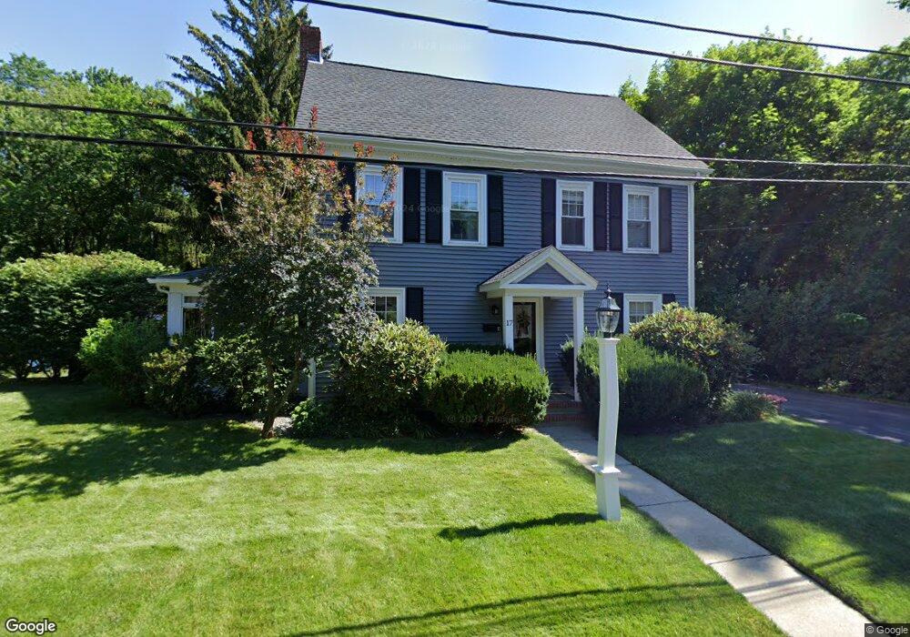
17 Ellis St Framingham, MA 01701
Estimated Value: $669,000 - $876,000
4
Beds
2
Baths
2,234
Sq Ft
$336/Sq Ft
Est. Value
About This Home
This home is located at 17 Ellis St, Framingham, MA 01701 and is currently estimated at $751,064, approximately $336 per square foot. 17 Ellis St is a home located in Middlesex County with nearby schools including Framingham High School, Summit Montessori School, and Saint Bridget School.
Ownership History
Date
Name
Owned For
Owner Type
Purchase Details
Closed on
Aug 23, 1991
Sold by
Deangelis Robert and Deangelis Grace
Bought by
King Theodore W and King Julie
Current Estimated Value
Home Financials for this Owner
Home Financials are based on the most recent Mortgage that was taken out on this home.
Original Mortgage
$172,900
Interest Rate
9.55%
Mortgage Type
Purchase Money Mortgage
Create a Home Valuation Report for This Property
The Home Valuation Report is an in-depth analysis detailing your home's value as well as a comparison with similar homes in the area
Home Values in the Area
Average Home Value in this Area
Purchase History
| Date | Buyer | Sale Price | Title Company |
|---|---|---|---|
| King Theodore W | $182,000 | -- | |
| King Theodore W | $182,000 | -- |
Source: Public Records
Mortgage History
| Date | Status | Borrower | Loan Amount |
|---|---|---|---|
| Open | King Theodore W | $154,000 | |
| Closed | King Theodore W | $161,000 | |
| Closed | King Theodore W | $172,900 |
Source: Public Records
Tax History Compared to Growth
Tax History
| Year | Tax Paid | Tax Assessment Tax Assessment Total Assessment is a certain percentage of the fair market value that is determined by local assessors to be the total taxable value of land and additions on the property. | Land | Improvement |
|---|---|---|---|---|
| 2025 | $7,209 | $603,800 | $303,500 | $300,300 |
| 2024 | $7,059 | $566,500 | $270,300 | $296,200 |
| 2023 | $6,730 | $514,100 | $241,200 | $272,900 |
| 2022 | $6,407 | $466,300 | $219,200 | $247,100 |
| 2021 | $6,207 | $441,800 | $210,800 | $231,000 |
| 2020 | $6,244 | $416,800 | $191,800 | $225,000 |
| 2019 | $6,169 | $401,100 | $191,800 | $209,300 |
| 2018 | $6,024 | $369,100 | $188,000 | $181,100 |
| 2017 | $5,691 | $340,600 | $169,000 | $171,600 |
| 2016 | $5,603 | $322,400 | $169,000 | $153,400 |
| 2015 | $5,904 | $331,300 | $184,300 | $147,000 |
Source: Public Records
Map
Nearby Homes
- 1186 Worcester Rd Unit 720
- 139 Salem End Rd
- 1327 Old Worcester Rd
- 341 Pleasant St
- 10 Main St Unit 507
- 26 Knight Rd
- 15 Clearview Dr
- 337 Edgell Rd
- 10 Kings Row Ln
- 1500 Worcester Rd Unit 202
- 1500 Worcester Rd Unit 502
- 1500 Worcester Rd Unit 215
- 1500 Worcester Rd Unit 624
- 1500 Worcester Rd Unit 217
- 53 Long Ave
- 67 Long Ave
- 401 Belknap Rd
- 29 Prescott St
- 609 Union Ave Unit 609
- 1550 Worcester Rd Unit 621