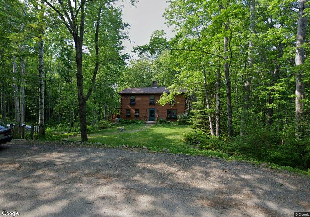
17 Hoffses Dr Camden, ME 04843
Estimated Value: $569,095 - $725,000
4
Beds
3
Baths
1,729
Sq Ft
$353/Sq Ft
Est. Value
About This Home
This home is located at 17 Hoffses Dr, Camden, ME 04843 and is currently estimated at $611,024, approximately $353 per square foot. 17 Hoffses Dr is a home located in Knox County with nearby schools including Camden-Rockport Elementary School, Camden-Rockport Middle School, and Camden Hills Regional High School.
Ownership History
Date
Name
Owned For
Owner Type
Purchase Details
Closed on
Oct 26, 2005
Sold by
White Bonnie V
Bought by
White Michael S and Dunavent-White Suzanne
Current Estimated Value
Home Financials for this Owner
Home Financials are based on the most recent Mortgage that was taken out on this home.
Original Mortgage
$200,000
Interest Rate
6%
Mortgage Type
Adjustable Rate Mortgage/ARM
Create a Home Valuation Report for This Property
The Home Valuation Report is an in-depth analysis detailing your home's value as well as a comparison with similar homes in the area
Home Values in the Area
Average Home Value in this Area
Purchase History
| Date | Buyer | Sale Price | Title Company |
|---|---|---|---|
| White Michael S | -- | -- |
Source: Public Records
Mortgage History
| Date | Status | Borrower | Loan Amount |
|---|---|---|---|
| Closed | White Michael S | $200,000 |
Source: Public Records
Tax History Compared to Growth
Tax History
| Year | Tax Paid | Tax Assessment Tax Assessment Total Assessment is a certain percentage of the fair market value that is determined by local assessors to be the total taxable value of land and additions on the property. | Land | Improvement |
|---|---|---|---|---|
| 2024 | $4,919 | $468,500 | $155,300 | $313,200 |
| 2023 | $4,355 | $315,600 | $64,500 | $251,100 |
| 2022 | $4,166 | $315,600 | $64,500 | $251,100 |
| 2021 | $4,037 | $263,000 | $67,900 | $195,100 |
| 2020 | $3,953 | $263,000 | $67,900 | $195,100 |
| 2019 | $3,921 | $263,000 | $67,900 | $195,100 |
| 2018 | $3,460 | $232,500 | $64,800 | $167,700 |
| 2017 | $3,343 | $232,500 | $64,800 | $167,700 |
| 2016 | $3,422 | $219,500 | $60,800 | $158,700 |
| 2015 | $3,321 | $219,500 | $60,800 | $158,700 |
| 2014 | $3,167 | $219,500 | $60,800 | $158,700 |
| 2013 | $3,082 | $219,500 | $60,800 | $158,700 |
Source: Public Records
Map
Nearby Homes
- 43 Melvin Heights Rd
- 315 Beaucaire Ave
- 11 A Mountainside Park
- 110 Mountain St
- 80 Cobb Rd
- 10 Glenfield Cir
- 1 Branch St
- 111 Start Rd
- 159 Mechanic St
- 161 Beaucaire Ave
- 424 Molyneaux Rd
- 91 Simonton Rd
- 122,6-1 Timbercliffe Dr
- 122,7-1 Timbercliffe Dr
- 00 Mountain Arrow Dr Unit LOT B
- 9 Harden Ave
- 33 Pearl St
- 2 Bald Mountain Rd
- 12 Free St
- 73 (2) Elm St