
17 Karen Ln Morgantown, WV 26501
South Hills NeighborhoodEstimated payment $1,759/month
Highlights
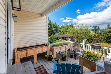
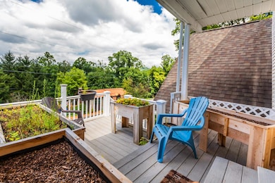
- Panoramic View
- Deck
- Private Yard
- South Middle School Rated A-
- Wood Flooring
- No HOA
About This Home
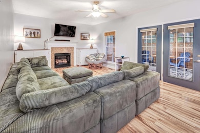
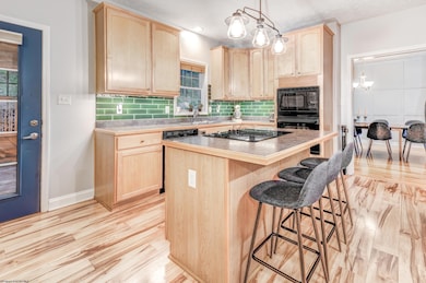
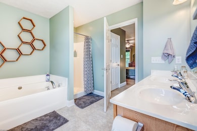
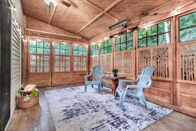
SECRET HIDEOUT Close to Town w/ Versatile + Flowing Layout! LOTs of updates, incl. NEW Roof! Tucked away on quiet street in perfect location, entrance to Marilla Park just at the corner! Front porch offers tranquility + VIEWs to reset that heartbeat. Room to garden raised-beds too, composite decking! Spacious foyer w/ hardwood floors flow into Kitchen or carpeted Gathering Room... a circular floorpan! Kitchen offers LOTs of storage options, island w/ cooktop + pantry! Front Office is a great space to use how you want (ohh + stare out to the clouds too). Entertain or relax on screened-in porch w/ custom wood designed “paw guards”. Side yard has a nice flat area that is useable + nice! Back area has charming patio w/ options to garden or plant! Primary Suite has entry-closet PLUS a dreamlike Bathroom w/ deep soaking tub + shower + 2x sinks! BONUS storage area in area leading towards spacious garage storage area! Don’t Wait, SEE NOW!
Home Details
Home Type
- Single Family
Est. Annual Taxes
- $2,142
Year Built
- Built in 2005
Lot Details
- 0.26 Acre Lot
- Lot Dimensions are 80 x 143
- Sloped Lot
- Private Yard
- Property is zoned Single Family Residential
Property Views
- Panoramic
- City Lights
- Mountain
- Neighborhood
Home Design
- Block Foundation
- Shingle Roof
- Vinyl Siding
- Modular or Manufactured Materials
Interior Spaces
- 2,004 Sq Ft Home
- 2-Story Property
- Ceiling Fan
- Gas Log Fireplace
- Formal Dining Room
- Screened Porch
- Crawl Space
- Fire and Smoke Detector
Kitchen
- Built-In Oven
- Range
- Dishwasher
- Disposal
Flooring
- Wood
- Wall to Wall Carpet
Bedrooms and Bathrooms
- 3 Bedrooms
- Walk-In Closet
- Soaking Tub
- Garden Bath
Laundry
- Dryer
- Washer
Parking
- 3 Car Garage
- Garage Door Opener
- On-Street Parking
Outdoor Features
- Balcony
- Deck
Schools
- Mountainview Elementary School
- South Middle School
- Morgantown High School
Utilities
- Forced Air Heating and Cooling System
- Heating System Uses Gas
- 200+ Amp Service
- Electric Water Heater
- High Speed Internet
- Cable TV Available
Listing and Financial Details
- Assessor Parcel Number 158.9
Community Details
Overview
- No Home Owners Association
Amenities
- Shops
- Public Transportation
Recreation
- Tennis Courts
- Community Playground
- Community Pool
- Park
Map
Home Values in the Area
Average Home Value in this Area
Tax History
| Year | Tax Paid | Tax Assessment Tax Assessment Total Assessment is a certain percentage of the fair market value that is determined by local assessors to be the total taxable value of land and additions on the property. | Land | Improvement |
|---|---|---|---|---|
| 2025 | $2,201 | $166,980 | $28,680 | $138,300 |
| 2024 | $2,201 | $166,980 | $28,680 | $138,300 |
| 2023 | $2,197 | $161,280 | $28,680 | $132,600 |
| 2022 | $2,043 | $160,260 | $28,680 | $131,580 |
| 2021 | $2,051 | $160,260 | $28,680 | $131,580 |
| 2020 | $2,077 | $161,700 | $28,680 | $133,020 |
| 2019 | $2,089 | $161,700 | $28,680 | $133,020 |
| 2018 | $2,112 | $163,080 | $28,680 | $134,400 |
| 2017 | $2,100 | $161,460 | $27,060 | $134,400 |
| 2016 | $2,129 | $162,840 | $27,060 | $135,780 |
| 2015 | $2,053 | $162,840 | $27,060 | $135,780 |
| 2014 | $1,958 | $161,280 | $25,980 | $135,300 |
Property History
| Date | Event | Price | List to Sale | Price per Sq Ft |
|---|---|---|---|---|
| 10/30/2025 10/30/25 | Price Changed | $300,000 | -3.2% | $150 / Sq Ft |
| 08/23/2025 08/23/25 | For Sale | $310,000 | -- | $155 / Sq Ft |
Purchase History
| Date | Type | Sale Price | Title Company |
|---|---|---|---|
| Deed | $240,000 | None Available |
Mortgage History
| Date | Status | Loan Amount | Loan Type |
|---|---|---|---|
| Open | $240,000 | New Conventional |
Source: North Central West Virginia REIN
MLS Number: 10161180
APN: 10-35-01580009
Disclaimer: Certain information contained herein is derived from information provided by parties other than Homes.com. All information provided is deemed reliable, but is not guaranteed to be accurate and should be independently verified.
![]() Data provided by North Central WV Real Estate Information Network, Inc.
Data provided by North Central WV Real Estate Information Network, Inc.
IDX information is provided exclusively for consumers’ personal non-commercial use and may not be used for any purpose other than to identify prospective properties consumers may be interested in purchasing.
- TBD Karen Ln
- TBD Vandalia Rd
- 0 Cooper St
- 100 Claremont Ct
- 763 S Hills Dr
- 756 Mountain View Place
- 1 Westminster Dr
- #2 Westminster Dr
- Lots 20 + 21 S Point Cir
- Lot 28 S Point Cir
- Lot 45 Courtney Ave
- 315 Nolan Ave
- 301 E Brockway Ave
- 220 & 222 E Brockway Ave
- 401 Conn St
- 621 Elmina St
- 108 Village Crest Dr
- 1041 Montrose Ave
- TBD Huntington Ave
- 0 Sabraton Ave
- 836 Augusta Ave
- 631 Arlington St
- 441 W Virginia Ave
- 441 W Virginia Ave
- 701 Richwood Ave Unit 407
- 488 Wilson Ave
- 1232 Montrose Ave
- 1230 Montrose Ave
- 1347 Montrose Ave Unit 3
- 1302 Sabraton Ave Unit 662
- 539 Pennsylvania Ave Unit 539 penn
- 809 Louise Ave
- 232 Reay Alley Unit 232
- 1495 Sabraton Ave
- 405 Kingwood St
- 833 Monongalia Ave Unit 4
- 833 Monongalia Ave Unit 2
- 248 Stonehurst Dr
- 327 Euclid Ave Unit B
- 330 Demain Ave Unit 330
