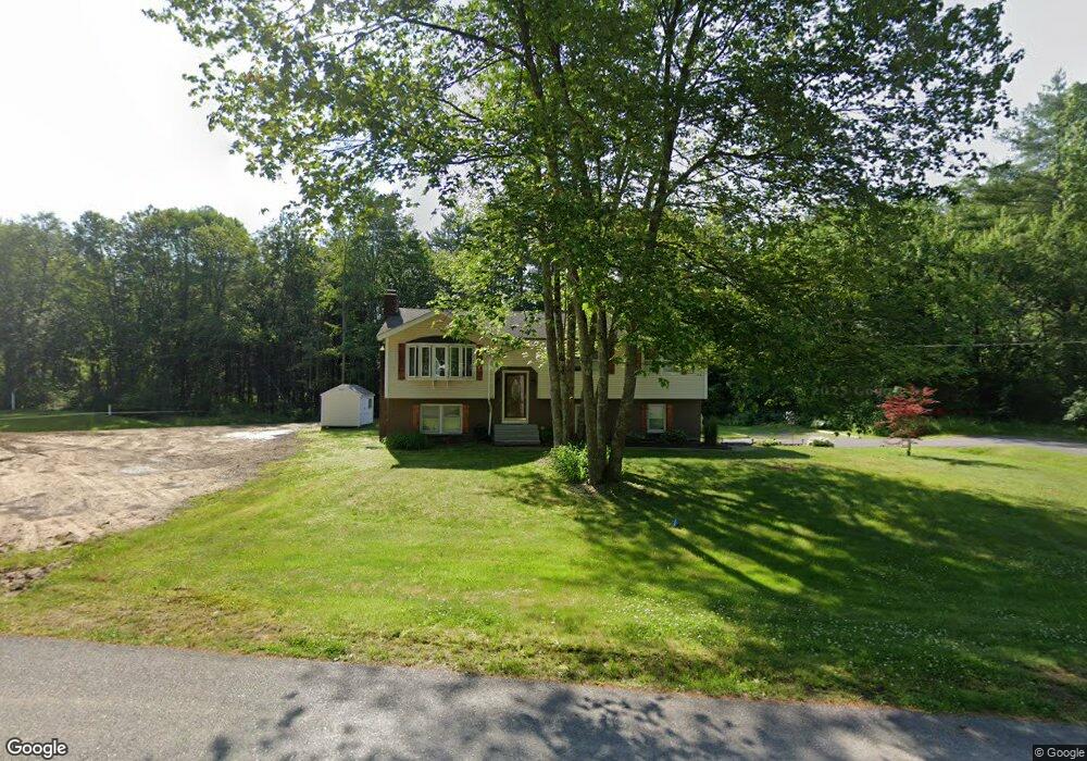
17 Level St MerriMacK, NH 03054
Estimated Value: $506,000 - $655,000
4
Beds
3
Baths
1,872
Sq Ft
$299/Sq Ft
Est. Value
About This Home
This home is located at 17 Level St, MerriMacK, NH 03054 and is currently estimated at $560,467, approximately $299 per square foot. 17 Level St is a home located in Hillsborough County with nearby schools including Reeds Ferry School, James Mastricola Upper Elementary School, and Merrimack Middle School.
Ownership History
Date
Name
Owned For
Owner Type
Purchase Details
Closed on
Apr 1, 2004
Sold by
Zabell Ellen and Zabell David
Bought by
Andrews Harold F and Andrews Shelley S
Current Estimated Value
Home Financials for this Owner
Home Financials are based on the most recent Mortgage that was taken out on this home.
Original Mortgage
$142,000
Interest Rate
5.56%
Mortgage Type
Purchase Money Mortgage
Create a Home Valuation Report for This Property
The Home Valuation Report is an in-depth analysis detailing your home's value as well as a comparison with similar homes in the area
Home Values in the Area
Average Home Value in this Area
Purchase History
| Date | Buyer | Sale Price | Title Company |
|---|---|---|---|
| Andrews Harold F | $205,000 | -- |
Source: Public Records
Mortgage History
| Date | Status | Borrower | Loan Amount |
|---|---|---|---|
| Open | Andrews Harold F | $123,000 | |
| Closed | Andrews Harold F | $130,152 | |
| Closed | Andrews Harold F | $14,000 | |
| Closed | Andrews Harold F | $142,000 |
Source: Public Records
Tax History Compared to Growth
Tax History
| Year | Tax Paid | Tax Assessment Tax Assessment Total Assessment is a certain percentage of the fair market value that is determined by local assessors to be the total taxable value of land and additions on the property. | Land | Improvement |
|---|---|---|---|---|
| 2024 | $7,635 | $369,000 | $200,500 | $168,500 |
| 2023 | $7,177 | $369,000 | $200,500 | $168,500 |
| 2022 | $6,413 | $369,000 | $200,500 | $168,500 |
| 2021 | $6,336 | $369,000 | $200,500 | $168,500 |
| 2020 | $6,280 | $261,000 | $135,600 | $125,400 |
| 2019 | $6,298 | $261,000 | $135,600 | $125,400 |
| 2018 | $6,295 | $261,000 | $135,600 | $125,400 |
| 2017 | $6,100 | $261,000 | $135,600 | $125,400 |
| 2016 | $5,948 | $261,000 | $135,600 | $125,400 |
| 2015 | $5,740 | $232,200 | $122,100 | $110,100 |
| 2014 | $5,594 | $232,200 | $122,100 | $110,100 |
| 2013 | $5,552 | $232,200 | $122,100 | $110,100 |
Source: Public Records
Map
Nearby Homes
- 5 Barbie Ct
- 29 Bedford Rd
- 16 Summit Rd
- 18 Horizon Dr
- 56 Greenfield Pkwy
- 38 Mallard Point
- 19 Vista Way
- 8 Donovan Ct
- 22 Kimberly Dr
- 1 Pleasant St
- 22 Clay St
- 10 Kingston Ct Unit 10
- 22 Essex Green Ct
- 11 Essex Green Ct
- 12 Clinton Ct
- 40 Seton Dr
- 10 Barrington Dr
- 98 Indian Rock Rd
- 5 Fernwood Dr
- 9 Mustang Dr Unit C
- 19 Level St
- 14 Paige Dr
- 12 Paige Dr
- 15 Paige Dr
- 21 Reeds Ferry Way Unit 28
- 11 Paige Dr
- 14 Acre Dr
- 22 Reeds Ferry Way Unit 25
- 19 Reeds Ferry Way Unit 29
- 20 Reeds Ferry Way
- 8 Acre Ln Unit 49
- 9 Paige Dr
- 17 Reeds Ferry Way
- 7 Paige Dr
- 6 Acre Ln Unit 48
- 7 Acre Ln Unit 52-1
- 18 Reeds Ferry Way
- 8 Paige Dr
- 15 Reeds Ferry Way Unit 31
- 4 Claire St Unit 64