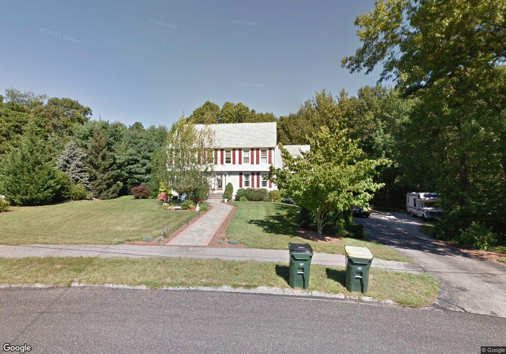
17 Longfellow Dr Franklin, MA 02038
Estimated Value: $808,251 - $951,000
4
Beds
3
Baths
2,380
Sq Ft
$369/Sq Ft
Est. Value
About This Home
This home is located at 17 Longfellow Dr, Franklin, MA 02038 and is currently estimated at $879,063, approximately $369 per square foot. 17 Longfellow Dr is a home located in Norfolk County with nearby schools including Helen Keller Elementary School, Annie Sullivan Middle School, and Franklin High School.
Ownership History
Date
Name
Owned For
Owner Type
Purchase Details
Closed on
Aug 6, 2014
Sold by
Munson Margaret L
Bought by
17 Longfellow Rt
Current Estimated Value
Purchase Details
Closed on
Oct 22, 2012
Sold by
Int Munson
Bought by
Munson Margaret L
Home Financials for this Owner
Home Financials are based on the most recent Mortgage that was taken out on this home.
Original Mortgage
$290,000
Interest Rate
3.57%
Mortgage Type
New Conventional
Purchase Details
Closed on
Apr 14, 2008
Sold by
Munson Margaret L
Bought by
Int Munson
Home Financials for this Owner
Home Financials are based on the most recent Mortgage that was taken out on this home.
Original Mortgage
$305,000
Interest Rate
6.3%
Mortgage Type
Purchase Money Mortgage
Purchase Details
Closed on
Mar 5, 1993
Sold by
Hesse John J and Hesse Cheryl A
Bought by
Poretsky Sheldon H
Create a Home Valuation Report for This Property
The Home Valuation Report is an in-depth analysis detailing your home's value as well as a comparison with similar homes in the area
Home Values in the Area
Average Home Value in this Area
Purchase History
| Date | Buyer | Sale Price | Title Company |
|---|---|---|---|
| 17 Longfellow Rt | -- | -- | |
| Munson Margaret L | -- | -- | |
| Int Munson | -- | -- | |
| Munson Margaret L | -- | -- | |
| Poretsky Sheldon H | $215,000 | -- |
Source: Public Records
Mortgage History
| Date | Status | Borrower | Loan Amount |
|---|---|---|---|
| Previous Owner | Munson Margaret L | $290,000 | |
| Previous Owner | Poretsky Sheldon H | $293,000 | |
| Previous Owner | Poretsky Sheldon H | $296,500 | |
| Previous Owner | Munson Margaret L | $305,000 | |
| Previous Owner | Poretsky Sheldon H | $250,000 |
Source: Public Records
Tax History Compared to Growth
Tax History
| Year | Tax Paid | Tax Assessment Tax Assessment Total Assessment is a certain percentage of the fair market value that is determined by local assessors to be the total taxable value of land and additions on the property. | Land | Improvement |
|---|---|---|---|---|
| 2025 | $7,602 | $654,200 | $331,000 | $323,200 |
| 2024 | $7,573 | $642,300 | $331,000 | $311,300 |
| 2023 | $7,279 | $578,600 | $282,100 | $296,500 |
| 2022 | $6,797 | $483,800 | $222,200 | $261,600 |
| 2021 | $6,598 | $450,400 | $249,500 | $200,900 |
| 2020 | $6,244 | $430,300 | $239,200 | $191,100 |
| 2019 | $6,159 | $420,100 | $229,000 | $191,100 |
| 2018 | $5,747 | $392,300 | $220,800 | $171,500 |
| 2017 | $5,482 | $376,000 | $204,500 | $171,500 |
| 2016 | $5,584 | $385,100 | $219,300 | $165,800 |
| 2015 | $5,553 | $374,200 | $208,400 | $165,800 |
| 2014 | $5,037 | $348,600 | $182,800 | $165,800 |
Source: Public Records
Map
Nearby Homes
- 266 Pleasant St
- 324 Pleasant St
- 67 Milliken Ave Unit 22
- 76 Dean Ave
- 48 Pinehurst St
- 17 Longhill Rd
- 159 E Central St
- 1 Uncas Ave
- 90 E Central St Unit 103
- 90 E Central St Unit 106
- 90 E Central St Unit 304
- 90 E Central St Unit 202
- 90 E Central St Unit 105
- 90 E Central St Unit 301
- 204 Lincoln St
- 40 Cross St
- 14 Pleasant St Unit A
- 64 Uncas Ave
- 70 Uncas Ave
- 99 Summer St
- 19 Longfellow Dr
- 15 Longfellow Dr
- 16 Longfellow Dr
- 18 Longfellow Dr
- 21 Longfellow Dr
- 13 Longfellow Dr
- 14 Longfellow Dr
- 20 Longfellow Dr
- 11 Longfellow Dr
- 22 Longfellow Dr
- 12 Longfellow Dr
- 1 Henry Ln
- 9 Longfellow Dr
- 3 Henry Ln
- 7 Longfellow Dr
- 2 Henry Ln
- 8 Longfellow Dr
- 4 Henry Ln
- 10 Maria Cir
- 5 Longfellow Dr