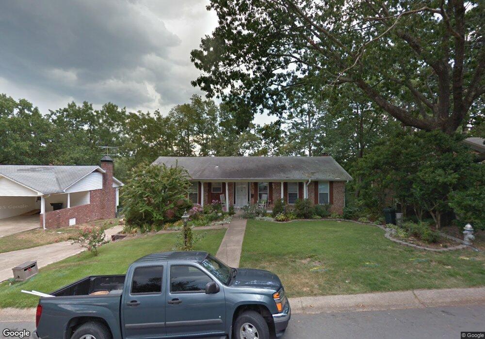
17 Nob View Cir Little Rock, AR 72205
Midtown Little Rock NeighborhoodEstimated Value: $290,480 - $331,000
--
Bed
4
Baths
2,535
Sq Ft
$122/Sq Ft
Est. Value
About This Home
This home is located at 17 Nob View Cir, Little Rock, AR 72205 and is currently estimated at $310,120, approximately $122 per square foot. 17 Nob View Cir is a home located in Pulaski County with nearby schools including Brady Elementary School, J.A. Fair K8 Preparatory School, and Henderson Middle School.
Ownership History
Date
Name
Owned For
Owner Type
Purchase Details
Closed on
Dec 22, 2020
Sold by
Om Flynn Llc
Bought by
Smith Evelyn L
Current Estimated Value
Purchase Details
Closed on
Jan 6, 2012
Sold by
Flynn O C and Flynn Martha H
Bought by
Flynn Martha H and Flynn O
Purchase Details
Closed on
Apr 3, 2000
Sold by
Flynn Oliver C and Flynn Martha
Bought by
Johnson Thelma
Purchase Details
Closed on
Mar 6, 2000
Sold by
Shelby Joe D and Shelby Leslie J
Bought by
Flynn Oliver C and Flynn Martha
Purchase Details
Closed on
Apr 14, 1977
Bought by
Flynn Oliver C and Flynn Martha H
Create a Home Valuation Report for This Property
The Home Valuation Report is an in-depth analysis detailing your home's value as well as a comparison with similar homes in the area
Home Values in the Area
Average Home Value in this Area
Purchase History
| Date | Buyer | Sale Price | Title Company |
|---|---|---|---|
| Smith Evelyn L | $60,000 | Lenders Title Company | |
| Flynn Martha H | -- | None Available | |
| Johnson Thelma | -- | American Abstract & Title Co | |
| Flynn Oliver C | -- | American Abstract & Title Co | |
| Flynn Oliver C | $54,000 | -- |
Source: Public Records
Tax History Compared to Growth
Tax History
| Year | Tax Paid | Tax Assessment Tax Assessment Total Assessment is a certain percentage of the fair market value that is determined by local assessors to be the total taxable value of land and additions on the property. | Land | Improvement |
|---|---|---|---|---|
| 2025 | $1,535 | $54,057 | $9,000 | $45,057 |
| 2024 | $1,535 | $54,057 | $9,000 | $45,057 |
| 2023 | $1,535 | $54,057 | $9,000 | $45,057 |
| 2022 | $1,160 | $54,057 | $9,000 | $45,057 |
| 2021 | $1,546 | $43,980 | $9,100 | $34,880 |
| 2020 | $1,160 | $43,980 | $9,100 | $34,880 |
| 2019 | $1,160 | $43,980 | $9,100 | $34,880 |
| 2018 | $1,185 | $43,980 | $9,100 | $34,880 |
| 2017 | $1,185 | $43,980 | $9,100 | $34,880 |
| 2016 | $1,185 | $37,440 | $7,800 | $29,640 |
| 2015 | $1,537 | $21,923 | $7,800 | $14,123 |
| 2014 | $1,537 | $21,923 | $7,800 | $14,123 |
Source: Public Records
Map
Nearby Homes
- 22 Nob View Cir
- 22 Nob Hill Cove
- 7 Brookfield Cove
- 814 Shea Dr
- 1204 Fawnwood Rd
- 7309 Gable Dr
- 307 Sunnymeade Dr
- 515 Brookside Dr
- 7616 Briarwood Cir
- 10 Stoney Brook Ct
- 621 Mcadoo St
- 7520 M St
- 419 Carpenter Dr
- 24 Evergreen Ct
- 1423 N Mississippi St
- 7303 L St
- 7505 N St
- 7701 Apache Rd
- 7203 L St
- 7513 Missouri Ave