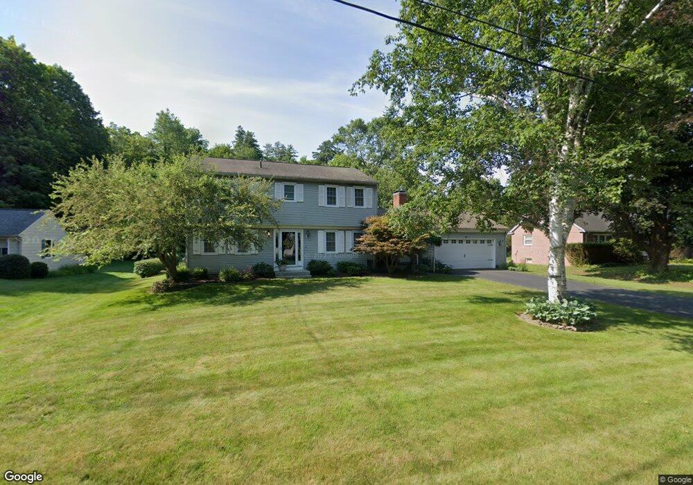
17 Pease St Wilbraham, MA 01095
Estimated Value: $473,178 - $557,000
4
Beds
3
Baths
2,058
Sq Ft
$255/Sq Ft
Est. Value
About This Home
This home is located at 17 Pease St, Wilbraham, MA 01095 and is currently estimated at $525,795, approximately $255 per square foot. 17 Pease St is a home located in Hampden County with nearby schools including Minnechaug Regional High School and Wilbraham & Monson Academy.
Ownership History
Date
Name
Owned For
Owner Type
Purchase Details
Closed on
Oct 17, 1986
Bought by
Ziemba James J and Ziemba Lucie N
Current Estimated Value
Create a Home Valuation Report for This Property
The Home Valuation Report is an in-depth analysis detailing your home's value as well as a comparison with similar homes in the area
Home Values in the Area
Average Home Value in this Area
Purchase History
| Date | Buyer | Sale Price | Title Company |
|---|---|---|---|
| Ziemba James J | $170,000 | -- |
Source: Public Records
Mortgage History
| Date | Status | Borrower | Loan Amount |
|---|---|---|---|
| Open | Ziemba James J | $30,000 | |
| Closed | Ziemba James J | $40,000 | |
| Closed | Ziemba James J | $50,000 |
Source: Public Records
Tax History Compared to Growth
Tax History
| Year | Tax Paid | Tax Assessment Tax Assessment Total Assessment is a certain percentage of the fair market value that is determined by local assessors to be the total taxable value of land and additions on the property. | Land | Improvement |
|---|---|---|---|---|
| 2025 | $7,030 | $393,200 | $91,800 | $301,400 |
| 2024 | $6,936 | $374,900 | $91,800 | $283,100 |
| 2023 | $6,600 | $353,200 | $91,800 | $261,400 |
| 2022 | $6,600 | $322,100 | $91,800 | $230,300 |
| 2021 | $6,319 | $275,200 | $108,800 | $166,400 |
| 2020 | $6,159 | $275,200 | $108,800 | $166,400 |
| 2019 | $5,999 | $275,200 | $108,800 | $166,400 |
| 2018 | $6,142 | $271,300 | $108,800 | $162,500 |
| 2017 | $5,969 | $271,300 | $108,800 | $162,500 |
| 2016 | $5,672 | $262,600 | $121,100 | $141,500 |
| 2015 | $5,483 | $262,600 | $121,100 | $141,500 |
Source: Public Records
Map
Nearby Homes
- 20 Old Orchard Rd
- 79 High Pine Cir
- 69 High Pine Cir
- 54 High Pine Cir
- 2 Vista Rd
- 2 Bayberry Dr Unit 51
- 28 Decorie Dr
- 474 Mountain Rd
- 474-480 Mountain Rd
- 35 Lake Dr
- 4 Hillcrest Dr
- 8 Patriot Ridge Ln
- 182 Mountain Rd
- 46 Washington Rd
- 6 Hilltop Park
- 12 Highridge Rd
- 603 Glendale Rd
- 68 Monson Rd
- 6 Teak Terrace Unit 24
- 99 Sandalwood Dr Unit site 00