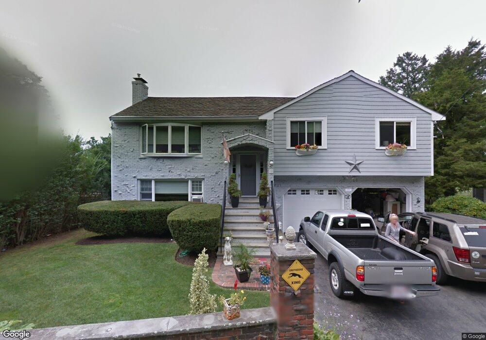
17 Puritan Ln Swampscott, MA 01907
Estimated Value: $1,075,935 - $1,199,000
4
Beds
3
Baths
2,100
Sq Ft
$538/Sq Ft
Est. Value
About This Home
This home is located at 17 Puritan Ln, Swampscott, MA 01907 and is currently estimated at $1,129,234, approximately $537 per square foot. 17 Puritan Ln is a home located in Essex County with nearby schools including Swampscott Middle School and Swampscott High School.
Ownership History
Date
Name
Owned For
Owner Type
Purchase Details
Closed on
Jul 30, 2004
Sold by
Sassine Andy H and Lavezzi-Sassine Victoria
Bought by
Orourke Eileen P and Malvarosa Julieann
Current Estimated Value
Purchase Details
Closed on
Jul 15, 1999
Sold by
Brown Helene E and Brown Glenn
Bought by
Sassine Andy H and Sassine Victoria P
Purchase Details
Closed on
Apr 25, 1997
Sold by
Loughlin John T and Loughlin Cathryn
Bought by
Brown Glenn and Brown Helene E
Create a Home Valuation Report for This Property
The Home Valuation Report is an in-depth analysis detailing your home's value as well as a comparison with similar homes in the area
Home Values in the Area
Average Home Value in this Area
Purchase History
| Date | Buyer | Sale Price | Title Company |
|---|---|---|---|
| Orourke Eileen P | $585,000 | -- | |
| Orourke Eileen P | $585,000 | -- | |
| Sassine Andy H | $352,500 | -- | |
| Sassine Andy H | $352,500 | -- | |
| Brown Glenn | $315,000 | -- | |
| Brown Glenn | $315,000 | -- |
Source: Public Records
Mortgage History
| Date | Status | Borrower | Loan Amount |
|---|---|---|---|
| Closed | Brown Glenn | $300,000 | |
| Closed | Brown Glenn | $368,000 |
Source: Public Records
Tax History Compared to Growth
Tax History
| Year | Tax Paid | Tax Assessment Tax Assessment Total Assessment is a certain percentage of the fair market value that is determined by local assessors to be the total taxable value of land and additions on the property. | Land | Improvement |
|---|---|---|---|---|
| 2025 | $10,714 | $934,100 | $505,900 | $428,200 |
| 2024 | $10,304 | $896,800 | $473,600 | $423,200 |
| 2023 | $9,585 | $816,400 | $430,600 | $385,800 |
| 2022 | $8,986 | $700,400 | $366,000 | $334,400 |
| 2021 | $8,501 | $616,000 | $301,400 | $314,600 |
| 2020 | $8,806 | $615,800 | $301,400 | $314,400 |
| 2019 | $9,033 | $594,300 | $279,900 | $314,400 |
| 2018 | $9,419 | $588,700 | $279,900 | $308,800 |
| 2017 | $9,444 | $541,200 | $250,300 | $290,900 |
| 2016 | $9,029 | $521,000 | $250,300 | $270,700 |
| 2015 | $8,935 | $521,000 | $250,300 | $270,700 |
| 2014 | $8,325 | $445,200 | $215,300 | $229,900 |
Source: Public Records
Map
Nearby Homes
- 110 Galloupes Point Rd
- 35 Alden Rd
- 8 Ocean View Rd
- 21 Bay View Dr
- 13 Cedar Hill Terrace Unit 2
- 75 Bay View Dr
- 35 Littles Point Rd Unit S201
- 24 Orchard Cir
- 71 Walnut Rd
- 71 Greenwood Ave Unit 207
- 140 Elmwood Rd
- 309 Paradise Rd
- 306 Paradise Rd
- 98 Paradise Rd
- 25 Manton Rd
- 28 Claremont Terrace Unit 4
- 28 Claremont Terrace Unit 6
- 37 Stanley Rd
- 30 Paradise Rd
- 108-110 Burrill St Unit 1