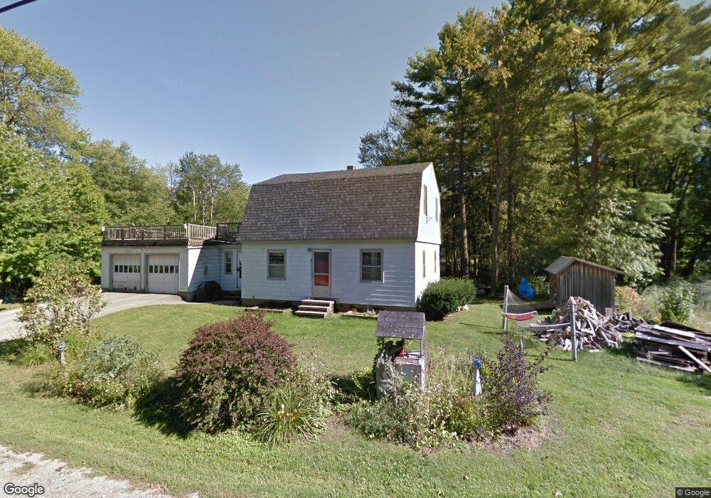
17 Riverside Dr Allenstown, NH 03275
Estimated Value: $514,000 - $535,126
3
Beds
3
Baths
2,071
Sq Ft
$253/Sq Ft
Est. Value
About This Home
This home is located at 17 Riverside Dr, Allenstown, NH 03275 and is currently estimated at $524,032, approximately $253 per square foot. 17 Riverside Dr is a home located in Merrimack County with nearby schools including Allenstown Elementary School, Armand R. Dupont School, and Tender Years Child Care & Learning Center.
Ownership History
Date
Name
Owned For
Owner Type
Purchase Details
Closed on
Aug 11, 2025
Sold by
Oconnor Devon and Oconnor Dillon
Bought by
Lavoie Steven J and Clark Kya-Lyn
Current Estimated Value
Home Financials for this Owner
Home Financials are based on the most recent Mortgage that was taken out on this home.
Original Mortgage
$472,500
Outstanding Balance
$472,095
Interest Rate
6.77%
Mortgage Type
New Conventional
Estimated Equity
$51,937
Purchase Details
Closed on
Oct 7, 2019
Sold by
Macdonald Lisa J and Macdonald Robert
Bought by
Oconnor Devon and Oconnor Dillon
Home Financials for this Owner
Home Financials are based on the most recent Mortgage that was taken out on this home.
Original Mortgage
$255,290
Interest Rate
4.5%
Mortgage Type
FHA
Purchase Details
Closed on
Oct 24, 2008
Sold by
Palys Daniel and Palys Margaret
Bought by
Fallon Noah N
Create a Home Valuation Report for This Property
The Home Valuation Report is an in-depth analysis detailing your home's value as well as a comparison with similar homes in the area
Home Values in the Area
Average Home Value in this Area
Purchase History
| Date | Buyer | Sale Price | Title Company |
|---|---|---|---|
| Lavoie Steven J | $525,000 | -- | |
| Lavoie Steven J | $525,000 | -- | |
| Oconnor Devon | $260,000 | -- | |
| Fallon Noah N | $8,100 | -- | |
| Fallon Noah N | $8,100 | -- |
Source: Public Records
Mortgage History
| Date | Status | Borrower | Loan Amount |
|---|---|---|---|
| Open | Lavoie Steven J | $472,500 | |
| Closed | Lavoie Steven J | $472,500 | |
| Previous Owner | Oconnor Devon | $255,290 | |
| Previous Owner | Fallon Noah N | $191,700 |
Source: Public Records
Tax History Compared to Growth
Tax History
| Year | Tax Paid | Tax Assessment Tax Assessment Total Assessment is a certain percentage of the fair market value that is determined by local assessors to be the total taxable value of land and additions on the property. | Land | Improvement |
|---|---|---|---|---|
| 2024 | $9,566 | $376,300 | $101,200 | $275,100 |
| 2023 | $7,978 | $376,300 | $101,200 | $275,100 |
| 2022 | $7,338 | $376,300 | $101,200 | $275,100 |
| 2021 | $7,399 | $234,900 | $65,900 | $169,000 |
| 2020 | $6,883 | $234,900 | $65,900 | $169,000 |
| 2019 | $7,305 | $234,900 | $65,900 | $169,000 |
| 2018 | $7,082 | $234,900 | $65,900 | $169,000 |
| 2017 | $7,543 | $234,900 | $65,900 | $169,000 |
| 2016 | $7,151 | $211,200 | $54,600 | $156,600 |
| 2015 | $6,907 | $210,400 | $54,600 | $155,800 |
| 2014 | $7,107 | $210,400 | $54,600 | $155,800 |
| 2013 | $6,634 | $210,400 | $54,600 | $155,800 |
Source: Public Records
Map
Nearby Homes
- 5 Jillerick Rd
- 36 Riverside Dr
- 106 River Rd
- 10 Albin Ave
- 9 Pine Acres Rd
- 6 Meadow Ln
- 1 1/2 Bartlett St
- 8 Sky View Terrace
- 230 Liberty Dr Unit B
- 1 Lane Dr
- 111 Glass St
- 10 Lane Dr
- 233 Pembroke St
- 2 Cheryl Dr
- 224 Pembroke St
- 11 Letendre Ave
- 163-165 Main St
- 422 Dawn Dr Unit 23
- 427 Dawn Dr Unit 15
- 101 4th Range Rd Unit 4
- 24 Riverside Dr
- 26 Riverside Dr
- 20 Riverside Dr
- 28 Riverside Dr
- 11 Riverside Dr
- 30 Riverside Dr
- 10 Riverside Dr
- 12 Riverside Dr
- 14 Riverside Dr
- 34 Riverside Dr
- 6 Riverside Dr
- 5 Riverside Dr
- 27 Riverside Dr
- 4 Riverside Dr
- 1 Riverside Park Rd
- 1 Riverside Dr
- 38 Riverside Dr
- 39 Riverside Dr Unit 1
- 39 Riverside Dr Unit 41
- 21 Fanny Dr