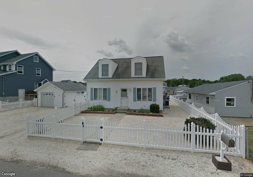
17 Sands Point Rd Waretown, NJ 08758
Estimated Value: $532,000 - $705,000
3
Beds
2
Baths
1,425
Sq Ft
$430/Sq Ft
Est. Value
About This Home
This home is located at 17 Sands Point Rd, Waretown, NJ 08758 and is currently estimated at $612,609, approximately $429 per square foot. 17 Sands Point Rd is a home located in Ocean County with nearby schools including Waretown Elementary School and Frederic A. Priff Elementary School.
Ownership History
Date
Name
Owned For
Owner Type
Purchase Details
Closed on
Jan 3, 2002
Sold by
Eckenrodge Lawrence
Bought by
Fanner Raymond and Fanner Arlene
Current Estimated Value
Purchase Details
Closed on
Feb 18, 1999
Sold by
Novak Kenneth E and Novak Lucy
Bought by
Eckenrode Lawrence E and Eckenrode Mary Ann
Home Financials for this Owner
Home Financials are based on the most recent Mortgage that was taken out on this home.
Original Mortgage
$100,000
Interest Rate
6.38%
Create a Home Valuation Report for This Property
The Home Valuation Report is an in-depth analysis detailing your home's value as well as a comparison with similar homes in the area
Home Values in the Area
Average Home Value in this Area
Purchase History
| Date | Buyer | Sale Price | Title Company |
|---|---|---|---|
| Fanner Raymond | $220,000 | -- | |
| Eckenrode Lawrence E | $165,000 | Chicago Title Insurance Co |
Source: Public Records
Mortgage History
| Date | Status | Borrower | Loan Amount |
|---|---|---|---|
| Previous Owner | Eckenrode Lawrence E | $100,000 |
Source: Public Records
Tax History Compared to Growth
Tax History
| Year | Tax Paid | Tax Assessment Tax Assessment Total Assessment is a certain percentage of the fair market value that is determined by local assessors to be the total taxable value of land and additions on the property. | Land | Improvement |
|---|---|---|---|---|
| 2025 | $9,259 | $613,600 | $345,200 | $268,400 |
| 2024 | $7,588 | $613,600 | $345,200 | $268,400 |
| 2023 | $7,082 | $337,400 | $197,700 | $139,700 |
| 2022 | $7,182 | $330,500 | $197,700 | $132,800 |
| 2021 | $6,813 | $330,500 | $197,700 | $132,800 |
| 2020 | $6,970 | $330,500 | $197,700 | $132,800 |
| 2019 | $6,835 | $330,500 | $197,700 | $132,800 |
| 2018 | $6,709 | $330,500 | $197,700 | $132,800 |
| 2017 | $6,481 | $330,500 | $197,700 | $132,800 |
| 2016 | $6,296 | $330,500 | $197,700 | $132,800 |
| 2015 | $6,131 | $330,500 | $197,700 | $132,800 |
| 2014 | $6,081 | $330,500 | $197,700 | $132,800 |
Source: Public Records
Map
Nearby Homes
- 5 Sands Point Rd
- 21 Compass Rd
- 36 Sands Point Rd
- 75 Dock Ave
- 150 Lighthouse Dr
- 35 Keelson Dr
- 113 Lighthouse Dr
- 3 Dock Ave
- 37 Keelson Dr
- 12 Mizzen Way
- 2 Gull Ct
- 4 Clubhouse Cir
- 1209 Plover Ct
- 23 Marlin Ln
- 13 Jolly Roger Way
- 908 Sarasota Dr
- 1001 E Panama Ct
- 1020 Sarasota Dr
- 1207 Spoonbill Ct
- 1012 E Panama Ct
- 44 Sands Point Rd
- 19 Sands Point Rd
- 13 Sands Point Rd
- 21 Sands Point Rd
- 20 Sands Point Rd
- 18 Sands Point Rd
- 11 Sands Point Rd
- 22 Sands Point Rd
- 23 Sands Point Rd
- 16 Capstan Rd
- 14 Capstan Rd
- 14 Sands Point Rd
- 18 Capstan Rd
- 24 Sands Point Rd
- 9 Sands Point Rd
- 12 Capstan Rd
- 20 Capstan Rd
- 12 Sands Point Rd
- 25 Sands Point Rd
- 10 Capstan Rd