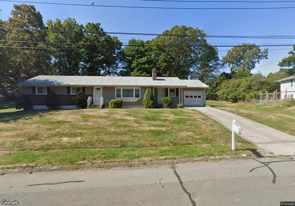
17 Sloop Ln Mystic, CT 06355
Mystic NeighborhoodEstimated Value: $581,000 - $705,000
3
Beds
2
Baths
1,668
Sq Ft
$383/Sq Ft
Est. Value
About This Home
This home is located at 17 Sloop Ln, Mystic, CT 06355 and is currently estimated at $639,625, approximately $383 per square foot. 17 Sloop Ln is a home located in New London County with nearby schools including Stonington Middle School and Stonington High School.
Ownership History
Date
Name
Owned For
Owner Type
Purchase Details
Closed on
Aug 16, 2006
Sold by
Champagne Prop Llc
Bought by
Mary Galli Packer T and Packer Mary Galli
Current Estimated Value
Purchase Details
Closed on
Apr 5, 2006
Sold by
Chester Millicent A
Bought by
Sportelli Monica M
Home Financials for this Owner
Home Financials are based on the most recent Mortgage that was taken out on this home.
Original Mortgage
$230,000
Interest Rate
6.26%
Create a Home Valuation Report for This Property
The Home Valuation Report is an in-depth analysis detailing your home's value as well as a comparison with similar homes in the area
Home Values in the Area
Average Home Value in this Area
Purchase History
| Date | Buyer | Sale Price | Title Company |
|---|---|---|---|
| Mary Galli Packer T | $363,000 | -- | |
| Mary Galli Packer T | $363,000 | -- | |
| Sportelli Monica M | $230,000 | -- | |
| Sportelli Monica M | $230,000 | -- |
Source: Public Records
Mortgage History
| Date | Status | Borrower | Loan Amount |
|---|---|---|---|
| Previous Owner | Sportelli Monica M | $230,000 |
Source: Public Records
Tax History
| Year | Tax Paid | Tax Assessment Tax Assessment Total Assessment is a certain percentage of the fair market value that is determined by local assessors to be the total taxable value of land and additions on the property. | Land | Improvement |
|---|---|---|---|---|
| 2025 | $6,484 | $324,500 | $119,600 | $204,900 |
| 2024 | $6,197 | $324,500 | $119,600 | $204,900 |
| 2023 | $6,235 | $324,500 | $119,600 | $204,900 |
| 2022 | $5,048 | $198,800 | $91,100 | $107,700 |
| 2021 | $5,075 | $198,800 | $91,100 | $107,700 |
| 2020 | $4,996 | $198,800 | $91,100 | $107,700 |
| 2019 | $4,992 | $198,800 | $91,100 | $107,700 |
| 2018 | $4,859 | $198,800 | $91,100 | $107,700 |
| 2017 | $4,670 | $188,300 | $91,100 | $97,200 |
| 2016 | $4,547 | $188,300 | $91,100 | $97,200 |
| 2015 | $4,357 | $188,300 | $91,100 | $97,200 |
| 2014 | $4,190 | $188,300 | $91,100 | $97,200 |
Source: Public Records
Map
Nearby Homes
- 215 Pequotsepos Rd
- 40 Holmes St
- 69 B Starr St
- 32 E Main St
- 7 Gravel St Unit 1
- 22 W Main St Unit 11
- 435 High St Unit 30
- 37 Hewitt Rd Unit B6
- 1198 River Rd
- 3 Water St Unit 305
- 44 Williams Ave
- 78 Cow Hill Rd
- 0 Smail St Unit 24066473
- 147 Pequot Ave
- 3 Hatch St
- 38 Deer Ridge Rd
- 50 Benjamin Stanton Pentway
- 439 Pequot Ave
- 29 Deer Ridge Rd
- 33 Deer Ridge Rd
Your Personal Tour Guide
Ask me questions while you tour the home.