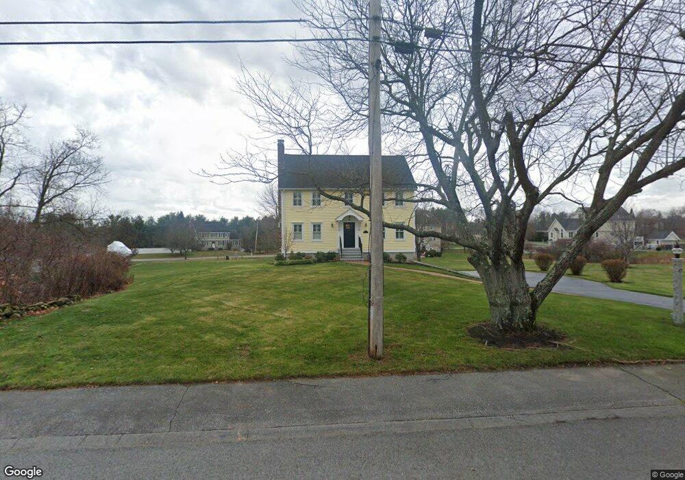
17 Wilshire Cir Dracut, MA 01826
Estimated Value: $717,431 - $881,000
4
Beds
3
Baths
1,961
Sq Ft
$407/Sq Ft
Est. Value
About This Home
This home is located at 17 Wilshire Cir, Dracut, MA 01826 and is currently estimated at $798,358, approximately $407 per square foot. 17 Wilshire Cir is a home located in Middlesex County with nearby schools including Joseph A. Campbell Elementary School, Richardson Middle School, and Dracut Senior High School.
Ownership History
Date
Name
Owned For
Owner Type
Purchase Details
Closed on
Dec 13, 1996
Sold by
Lafferty Thomas Est
Bought by
Brandt David M and Brandt Donna M
Current Estimated Value
Home Financials for this Owner
Home Financials are based on the most recent Mortgage that was taken out on this home.
Original Mortgage
$130,000
Outstanding Balance
$13,274
Interest Rate
7.75%
Mortgage Type
Purchase Money Mortgage
Estimated Equity
$785,084
Create a Home Valuation Report for This Property
The Home Valuation Report is an in-depth analysis detailing your home's value as well as a comparison with similar homes in the area
Home Values in the Area
Average Home Value in this Area
Purchase History
| Date | Buyer | Sale Price | Title Company |
|---|---|---|---|
| Brandt David M | $199,000 | -- |
Source: Public Records
Mortgage History
| Date | Status | Borrower | Loan Amount |
|---|---|---|---|
| Open | Brandt David M | $130,000 | |
| Previous Owner | Brandt David M | $88,000 |
Source: Public Records
Tax History Compared to Growth
Tax History
| Year | Tax Paid | Tax Assessment Tax Assessment Total Assessment is a certain percentage of the fair market value that is determined by local assessors to be the total taxable value of land and additions on the property. | Land | Improvement |
|---|---|---|---|---|
| 2025 | $6,716 | $663,600 | $251,600 | $412,000 |
| 2024 | $6,551 | $626,900 | $239,800 | $387,100 |
| 2023 | $6,348 | $548,200 | $208,500 | $339,700 |
| 2022 | $6,143 | $499,800 | $189,600 | $310,200 |
| 2021 | $5,927 | $455,600 | $172,200 | $283,400 |
| 2020 | $5,823 | $436,200 | $167,000 | $269,200 |
| 2019 | $5,569 | $405,000 | $159,000 | $246,000 |
| 2018 | $5,577 | $394,400 | $159,000 | $235,400 |
| 2017 | $5,536 | $394,400 | $159,000 | $235,400 |
| 2016 | $5,431 | $366,000 | $159,800 | $206,200 |
| 2015 | $5,317 | $356,100 | $159,800 | $196,300 |
| 2014 | $4,977 | $343,500 | $159,800 | $183,700 |
Source: Public Records
Map
Nearby Homes
- 39 Wilshire Cir
- 29 Wilshire Cir
- 18 Wilshire Cir
- 49 Wilshire Cir
- 12 Wilshire Cir
- 7 Wilshire Cir
- 38 Wilshire Cir
- 6 Wilshire Cir
- 44 Wilshire Cir
- 55 Wilshire Cir
- 32 Wilshire Cir
- 4 Elizabeth Dr
- 50 Wilshire Cir
- 5 Elizabeth Dr
- 2 Wilshire Cir
- 56 Wilshire Cir
- 571 Wheeler Rd
- 10 Elizabeth Dr
- 585 Wheeler Rd
- 599 Wheeler Rd