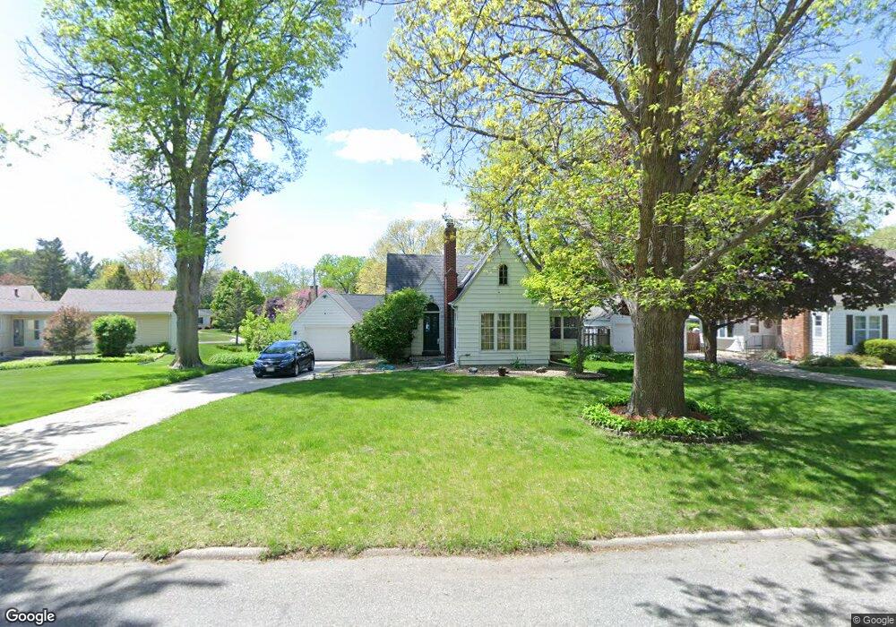
170 Hampshire Rd Waterloo, IA 50701
Estimated Value: $197,109 - $225,000
2
Beds
2
Baths
1,320
Sq Ft
$159/Sq Ft
Est. Value
About This Home
This home is located at 170 Hampshire Rd, Waterloo, IA 50701 and is currently estimated at $209,527, approximately $158 per square foot. 170 Hampshire Rd is a home located in Black Hawk County with nearby schools including Kingsley Elementary School, Hoover Middle School, and West High School.
Ownership History
Date
Name
Owned For
Owner Type
Purchase Details
Closed on
Feb 14, 2008
Sold by
Richardson Michelle C and Mcfee Michelle C
Bought by
Mcfee Matthew D
Current Estimated Value
Home Financials for this Owner
Home Financials are based on the most recent Mortgage that was taken out on this home.
Original Mortgage
$137,750
Interest Rate
5.75%
Mortgage Type
New Conventional
Create a Home Valuation Report for This Property
The Home Valuation Report is an in-depth analysis detailing your home's value as well as a comparison with similar homes in the area
Purchase History
| Date | Buyer | Sale Price | Title Company |
|---|---|---|---|
| Mcfee Matthew D | $145,000 | None Available |
Source: Public Records
Mortgage History
| Date | Status | Borrower | Loan Amount |
|---|---|---|---|
| Closed | Mcfee Matthew D | $137,750 |
Source: Public Records
Tax History
| Year | Tax Paid | Tax Assessment Tax Assessment Total Assessment is a certain percentage of the fair market value that is determined by local assessors to be the total taxable value of land and additions on the property. | Land | Improvement |
|---|---|---|---|---|
| 2025 | $3,878 | $195,030 | $29,330 | $165,700 |
| 2024 | $3,878 | $188,990 | $29,330 | $159,660 |
| 2023 | $2,990 | $185,030 | $29,330 | $155,700 |
| 2022 | $2,908 | $145,010 | $29,330 | $115,680 |
| 2021 | $2,966 | $145,010 | $29,330 | $115,680 |
| 2020 | $2,912 | $139,510 | $23,830 | $115,680 |
| 2019 | $2,912 | $139,510 | $23,830 | $115,680 |
| 2018 | $2,916 | $139,510 | $23,830 | $115,680 |
| 2017 | $3,008 | $139,510 | $23,830 | $115,680 |
| 2016 | $2,968 | $139,510 | $23,830 | $115,680 |
| 2015 | $2,968 | $139,510 | $23,830 | $115,680 |
| 2014 | $2,884 | $133,420 | $23,830 | $109,590 |
Source: Public Records
Map
Nearby Homes
- 2310 Westview Ave
- Lot 10 Paradise Estates First Addition
- Lot 44 Paradise Estates First Addition
- Lot 29 Paradise Estates First Addition
- Lot 1
- Lot 27 Paradise Estates First Addition
- Lot 54 Paradise Estates First Addition
- Lot 63 Paradise Estates First Addition
- Lot 39 Paradise Estates First Addition
- Lot 42 Paradise Estates First Addition
- Lot 13 Paradise Estates First Addition
- Lot 41 Paradise Estates First Addition
- Lot 14 Paradise Estates First Addition
- Lot 61 Paradise Estates First Addition
- Lot 53 Paradise Estates First Addition
- Lot 55 Paradise Estates First Addition
- Lot 9 Paradise Estates First Addition
- Lot 37 Paradise Estates First Addition
- Lot 3 Paradise Estates First Addition
- Lot 7 Paradise Estates First Addition
- 160 Hampshire Rd
- 171 Hampshire Rd
- 161 Hampshire Rd
- 147 Norfolk Rd
- 155 Norfolk Rd
- 137 Norfolk Rd
- 150 Hampshire Rd
- 153 Hampshire Rd
- 179 Hampshire Rd
- 129 Norfolk Rd
- 142 Hampshire Rd
- 141 Hampshire Rd
- 191 Hampshire Rd
- 240 Sheridan Rd
- 232 Sheridan Rd
- 160 Norfolk Rd
- 146 Norfolk Rd
- 132 Hampshire Rd
- 256 Sheridan Rd
- 140 Norfolk Rd
Your Personal Tour Guide
Ask me questions while you tour the home.