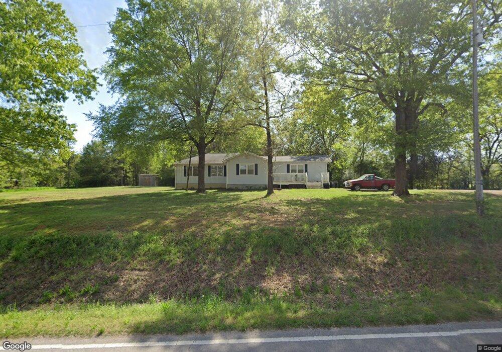
1700 Double Bridge Rd Steele, AL 35987
Estimated Value: $123,000 - $216,000
Studio
--
Bath
1,940
Sq Ft
$91/Sq Ft
Est. Value
About This Home
This home is located at 1700 Double Bridge Rd, Steele, AL 35987 and is currently estimated at $175,953, approximately $90 per square foot. 1700 Double Bridge Rd is a home located in St. Clair County with nearby schools including Ashville Elementary School, Ashville Middle School, and Ashville High School.
Ownership History
Date
Name
Owned For
Owner Type
Purchase Details
Closed on
Oct 11, 2016
Sold by
Wall James D
Bought by
Wall Davina
Current Estimated Value
Purchase Details
Closed on
Feb 10, 2006
Sold by
Wall James and Wall Davina
Bought by
Hudson Sharon
Create a Home Valuation Report for This Property
The Home Valuation Report is an in-depth analysis detailing your home's value as well as a comparison with similar homes in the area
Home Values in the Area
Average Home Value in this Area
Purchase History
| Date | Buyer | Sale Price | Title Company |
|---|---|---|---|
| Wall Davina | -- | None Available | |
| Hudson Sharon | -- | None Available |
Source: Public Records
Tax History
| Year | Tax Paid | Tax Assessment Tax Assessment Total Assessment is a certain percentage of the fair market value that is determined by local assessors to be the total taxable value of land and additions on the property. | Land | Improvement |
|---|---|---|---|---|
| 2024 | $349 | $25,582 | $2,360 | $23,222 |
| 2023 | $349 | $25,582 | $2,360 | $23,222 |
| 2022 | $356 | $13,024 | $890 | $12,134 |
| 2021 | $274 | $13,026 | $892 | $12,134 |
| 2020 | $274 | $10,375 | $896 | $9,479 |
| 2019 | $274 | $10,375 | $896 | $9,479 |
| 2018 | $242 | $9,340 | $0 | $0 |
| 2017 | $95 | $8,580 | $0 | $0 |
| 2016 | $224 | $8,580 | $0 | $0 |
| 2015 | $95 | $4,680 | $0 | $0 |
| 2014 | $95 | $4,600 | $0 | $0 |
Source: Public Records
Map
Nearby Homes
- 32960 US Highway 411
- 0 Highway 11 Unit 21427361
- 0 Legion Dr Unit 893391
- 0 Legion Dr Unit 19987726
- 145 Cross Creek Ln
- 61 Hartsfield Dr
- 36240 US Hwy 231
- 15 Dorough St
- 0 US Hwy 231 Unit 21398012
- 0 US Hwy 231 Unit 21438521
- 115 Canoe Dr
- 435 5th St
- 31 3rd Ave
- 424 7th Ave
- 12215 Alabama 23
- 3074 Beason Cove Rd
- 799 10th St
- 0 Sweatt Rd Unit 21415006
- 19099 US Highway 11
- 665 Stolle Farm Rd
- 1061 Double Bridge Rd
- 1061 Double Bridge Rd
- 0 Double Bridge Rd Unit 1 834763
- 0 Double Bridge Rd Unit 16 845128
- 0 Double Bridge Rd Unit 1 1337844
- 0 Double Bridge Rd Unit 1304526
- 0 Double Bridge Rd Unit 1 851119
- 00 Double Bridge Rd Unit 11
- 2376 Double Bridge Rd
- 2493 Double Bridge Rd
- 2292 Double Bridge Rd
- 2551 Double Bridge Rd
- 2127 Double Bridge Rd
- 245 Pine Lane Cir
- 2615 Double Bridge Rd
- 2701 Double Bridge Rd
- 1653 Double Bridge Rd
- 1116 Double Bridge Rd
- 1104 Double Bridge Rd
- 1100 Double Bridge Rd
Your Personal Tour Guide
Ask me questions while you tour the home.