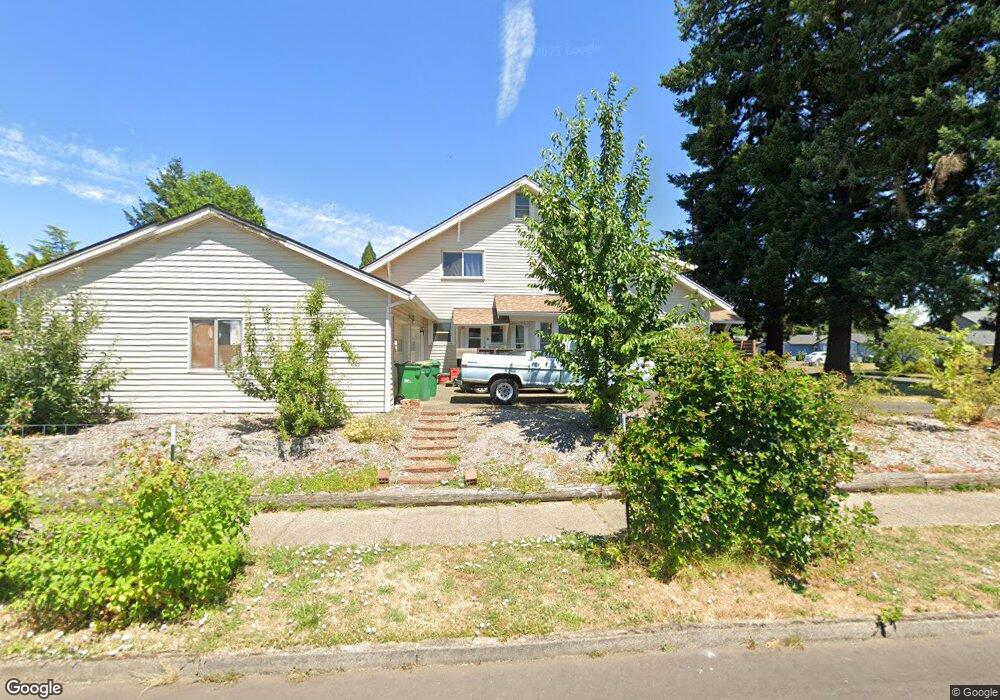
1700 Fir Rd Forest Grove, OR 97116
Estimated Value: $505,000 - $612,000
4
Beds
3
Baths
2,423
Sq Ft
$228/Sq Ft
Est. Value
About This Home
This home is located at 1700 Fir Rd, Forest Grove, OR 97116 and is currently estimated at $552,746, approximately $228 per square foot. 1700 Fir Rd is a home located in Washington County with nearby schools including Fern Hill Elementary School, Neil Armstrong Middle School, and Tom McCall Upper Elementary School.
Ownership History
Date
Name
Owned For
Owner Type
Purchase Details
Closed on
Dec 3, 2019
Sold by
Friis Daniel R
Bought by
Fries Matthew R N and Frees Andrew D P
Current Estimated Value
Purchase Details
Closed on
Jan 2, 2018
Sold by
Friis Daniel R
Bought by
Friis Daniel R and Friis Kerry A
Home Financials for this Owner
Home Financials are based on the most recent Mortgage that was taken out on this home.
Original Mortgage
$155,000
Interest Rate
3.92%
Mortgage Type
New Conventional
Purchase Details
Closed on
Jan 21, 2016
Sold by
Friis Daniel R
Bought by
Friis Daniel R and Daniel R Friis Trust
Purchase Details
Closed on
Apr 11, 2014
Sold by
Fries David
Bought by
Friis Daniel R
Purchase Details
Closed on
Feb 24, 2014
Sold by
Fries David
Bought by
Friis Daniel R
Create a Home Valuation Report for This Property
The Home Valuation Report is an in-depth analysis detailing your home's value as well as a comparison with similar homes in the area
Home Values in the Area
Average Home Value in this Area
Purchase History
| Date | Buyer | Sale Price | Title Company |
|---|---|---|---|
| Fries Matthew R N | -- | None Available | |
| Friis Daniel R | -- | First American Title | |
| Friis Daniel R | -- | First American Title Ins Co | |
| Friis Daniel R | -- | First American Title | |
| Friis Daniel R | -- | None Available | |
| Friis Daniel R | -- | None Available | |
| Friis Daniel R | -- | None Available |
Source: Public Records
Mortgage History
| Date | Status | Borrower | Loan Amount |
|---|---|---|---|
| Previous Owner | Friis Daniel R | $155,000 |
Source: Public Records
Tax History Compared to Growth
Tax History
| Year | Tax Paid | Tax Assessment Tax Assessment Total Assessment is a certain percentage of the fair market value that is determined by local assessors to be the total taxable value of land and additions on the property. | Land | Improvement |
|---|---|---|---|---|
| 2026 | $4,045 | $227,160 | -- | -- |
| 2025 | $4,045 | $220,550 | -- | -- |
| 2024 | $3,903 | $214,130 | -- | -- |
| 2023 | $3,903 | $207,900 | $0 | $0 |
| 2022 | $3,412 | $207,900 | $0 | $0 |
| 2021 | $3,368 | $195,980 | $0 | $0 |
| 2020 | $3,350 | $190,280 | $0 | $0 |
| 2019 | $3,276 | $184,740 | $0 | $0 |
| 2018 | $3,175 | $179,360 | $0 | $0 |
| 2017 | $3,077 | $174,140 | $0 | $0 |
| 2016 | $2,990 | $169,070 | $0 | $0 |
| 2015 | $2,875 | $164,150 | $0 | $0 |
| 2014 | $2,862 | $159,370 | $0 | $0 |
Source: Public Records
Map
Nearby Homes
- 3404 19th Ave Unit 103
- 3404 19th Ave Unit 215
- 1835 Tamarack Ct
- 1832 Vine Ct
- 3213 Maple Place
- 3128 Brittany Dr
- 3831 Pacific Ave Unit D5
- 3831 Pacific Ave Unit D2
- 1506 Pioneer Cir
- 2902 19th Ave
- 1504 Frontier Cir
- 3839 Pacific Ave Unit 102
- 1402 Pioneer Way
- 2824 19th Ave
- 4303 Settlers Loop
- 2815 18th Ave
- 4403 Wagon Wheel Cir
- 1509 Centennial Cir
- 0 22nd Ave Unit 11
- 2743 15th Place