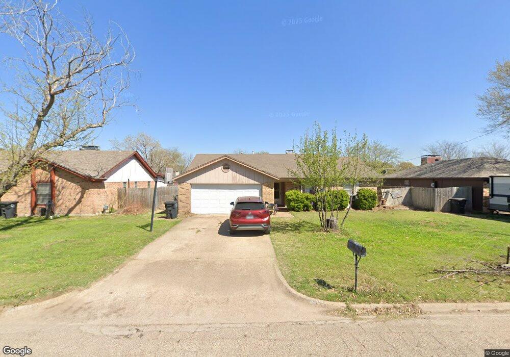
1700 Spring Branch Dr Cleburne, TX 76033
Estimated Value: $242,468 - $257,000
3
Beds
2
Baths
1,635
Sq Ft
$153/Sq Ft
Est. Value
About This Home
This home is located at 1700 Spring Branch Dr, Cleburne, TX 76033 and is currently estimated at $249,367, approximately $152 per square foot. 1700 Spring Branch Dr is a home located in Johnson County with nearby schools including Marti Elementary School, A.D. Wheat Middle School, and Cleburne High School.
Ownership History
Date
Name
Owned For
Owner Type
Purchase Details
Closed on
Nov 30, 2005
Sold by
Bullard David and Bullard Julie
Bought by
Moon Andrew and Moon Wendy
Current Estimated Value
Home Financials for this Owner
Home Financials are based on the most recent Mortgage that was taken out on this home.
Original Mortgage
$97,000
Outstanding Balance
$63,968
Interest Rate
9.5%
Mortgage Type
Adjustable Rate Mortgage/ARM
Estimated Equity
$185,399
Create a Home Valuation Report for This Property
The Home Valuation Report is an in-depth analysis detailing your home's value as well as a comparison with similar homes in the area
Home Values in the Area
Average Home Value in this Area
Purchase History
| Date | Buyer | Sale Price | Title Company |
|---|---|---|---|
| Moon Andrew | -- | Fatco |
Source: Public Records
Mortgage History
| Date | Status | Borrower | Loan Amount |
|---|---|---|---|
| Open | Moon Andrew | $97,000 |
Source: Public Records
Tax History
| Year | Tax Paid | Tax Assessment Tax Assessment Total Assessment is a certain percentage of the fair market value that is determined by local assessors to be the total taxable value of land and additions on the property. | Land | Improvement |
|---|---|---|---|---|
| 2025 | $5,922 | $265,584 | $44,000 | $221,584 |
| 2024 | $5,922 | $265,584 | $44,000 | $221,584 |
| 2023 | $5,060 | $227,380 | $44,000 | $183,380 |
| 2022 | $5,584 | $223,123 | $37,750 | $185,373 |
| 2021 | $4,466 | $171,174 | $34,000 | $137,174 |
| 2020 | $4,094 | $147,735 | $25,000 | $122,735 |
| 2019 | $4,365 | $147,735 | $25,000 | $122,735 |
| 2018 | $3,727 | $126,076 | $25,000 | $101,076 |
| 2017 | $3,711 | $126,076 | $25,000 | $101,076 |
| 2016 | $3,507 | $119,134 | $15,000 | $104,134 |
Source: Public Records
Map
Nearby Homes
- 2205 Towne North Dr
- 1605 Woodside Ln E
- 2012 Pebblecreek Dr
- 1700 Brookhaven St
- 1419 Kilpatrick Ct
- 1403 Courtney Place
- 2004 Fall Creek Rd
- 1418 Smooth Stone Dr
- 1609 River Bend Rd
- 2209 N Nolan River Rd
- 1413 Phillips St
- 1416 Mimosa St
- 1300 Holly St
- 1102 Holly St
- 1418 Quail Creek Dr
- 1402 Dry Creek Dr
- 1408 Quail Creek Dr
- 1202 Holly St
- 568 Marsh St
- 905 Euclid St
- 1608 Spring Branch Dr
- 1702 Spring Branch Dr
- 1606 Spring Branch Dr
- 1603 Morningside Dr
- 1704 Spring Branch Dr
- 1601 Morningside Dr
- 1605 Morningside Dr
- 1701 Spring Branch Dr
- 1703 Spring Branch Dr
- 1607 Morningside Dr
- 1604 Spring Branch Dr
- 1521 Morningside Dr
- 1607 Spring Branch Dr
- 2915 Pebblecreek Dr
- 1705 Spring Branch Dr
- 1519 Morningside Dr
- 1605 Spring Branch Dr
- 1602 Spring Branch Dr
- 1707 Spring Branch Dr
- 2206 Pebblecreek Dr
Your Personal Tour Guide
Ask me questions while you tour the home.