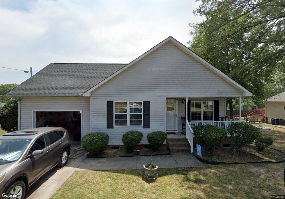
1701 Bernard Ave Kannapolis, NC 28083
Estimated Value: $270,506 - $280,000
3
Beds
2
Baths
1,297
Sq Ft
$211/Sq Ft
Est. Value
About This Home
This home is located at 1701 Bernard Ave, Kannapolis, NC 28083 and is currently estimated at $273,377, approximately $210 per square foot. 1701 Bernard Ave is a home located in Cabarrus County with nearby schools including Forest Park Elementary School, Kannapolis Middle, and A.L. Brown High School.
Ownership History
Date
Name
Owned For
Owner Type
Purchase Details
Closed on
Apr 12, 2001
Sold by
Cabarrus Cnty Cmnty Development Corp Inc
Bought by
Bennett Jimmy and Bennett Verleen
Current Estimated Value
Home Financials for this Owner
Home Financials are based on the most recent Mortgage that was taken out on this home.
Original Mortgage
$102,007
Outstanding Balance
$37,576
Interest Rate
7.01%
Mortgage Type
FHA
Estimated Equity
$235,801
Create a Home Valuation Report for This Property
The Home Valuation Report is an in-depth analysis detailing your home's value as well as a comparison with similar homes in the area
Home Values in the Area
Average Home Value in this Area
Purchase History
| Date | Buyer | Sale Price | Title Company |
|---|---|---|---|
| Bennett Jimmy | $109,000 | -- |
Source: Public Records
Mortgage History
| Date | Status | Borrower | Loan Amount |
|---|---|---|---|
| Open | Bennett Jimmy | $102,007 |
Source: Public Records
Tax History
| Year | Tax Paid | Tax Assessment Tax Assessment Total Assessment is a certain percentage of the fair market value that is determined by local assessors to be the total taxable value of land and additions on the property. | Land | Improvement |
|---|---|---|---|---|
| 2025 | -- | $252,500 | $50,000 | $202,500 |
| 2024 | $2,867 | $252,500 | $50,000 | $202,500 |
| 2023 | $2,253 | $164,420 | $60,370 | $104,050 |
| 2022 | $2,272 | $165,810 | $63,120 | $102,690 |
| 2021 | $2,272 | $165,810 | $63,120 | $102,690 |
| 2020 | $2,272 | $165,810 | $63,120 | $102,690 |
| 2019 | $1,520 | $110,960 | $20,000 | $90,960 |
| 2018 | $1,498 | $110,960 | $20,000 | $90,960 |
| 2017 | $1,476 | $110,960 | $20,000 | $90,960 |
| 2016 | $1,476 | $109,630 | $20,000 | $89,630 |
| 2015 | $1,381 | $109,630 | $20,000 | $89,630 |
| 2014 | $1,381 | $109,630 | $20,000 | $89,630 |
Source: Public Records
Map
Nearby Homes
- 1655 Garnett St
- 1365 Eagle Claw Dr
- 1768 Concord Lake Rd
- 2122 Centergrove Rd
- 2485 Acadia Ct
- 1010 A-B Tennessee St
- 2203 Florida Ave
- 610 Eddleman Rd
- 611 Sumner St
- 2458 Saguaro Ln
- 620 Marigold Dr
- 307 S Little Texas Rd
- 1025 Michigan St
- 1699 Mission Oaks St
- 1615 Eastwood Dr
- 1010 Kentucky St
- 127 Eddleman Rd
- 2271 Knowles St
- 302 Suburban Ave
- 1052 Mclain Rd
- 1205 Holland St
- 1643 Bernard Ave
- 1645 Bernard Ave
- 1203 Holland St
- 1209 Holland St
- 1201 Holland St
- 1211 Holland St
- 1712 Bernard Ave
- 1213 Holland St
- 1109 Rhode Island Ave
- 1720 Bernard Ave
- 1204 Holland St
- 1208 Holland St
- 1632 Bernard Ave
- 1202 Holland St
- 1210 Holland St
- 1728 Bernard Ave
- 1215 Holland St
- 1200 Holland St
- 1107 Rhode Island Ave
Your Personal Tour Guide
Ask me questions while you tour the home.