
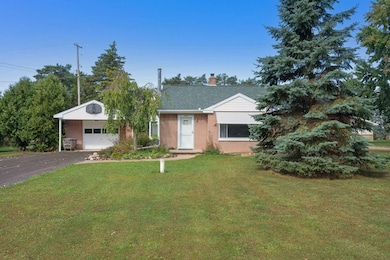
1701 Copas Rd Owosso, MI 48867
Estimated payment $1,389/month
Highlights
- Wood Burning Stove
- Pole Barn
- Fireplace
- Wood Flooring
- No HOA
- 1 Car Attached Garage
About This Lot
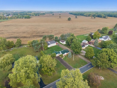
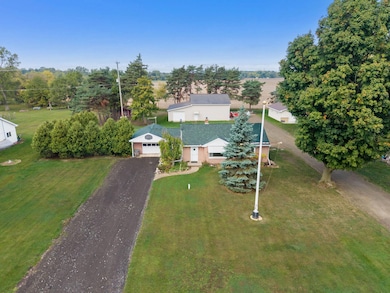
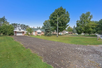
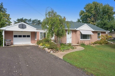
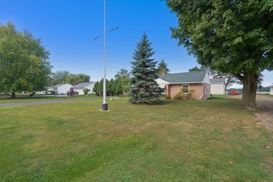
Welcome home to this solid, well maintained brick 3 bedroom ranch offering comfort, convenience, and modern updates. Step inside to a spacious living area highlighted by a wood burning fireplace, perfect for those relaxing evenings. This home has been thoughtfully updated with a new well, new furnace, central air, updated plumbing, a newer roof with 50 yr. shingles, and more. Giving you peace of mind for years to come. The attached garage and double driveway provide plenty of parking and convenience for family and guests. Sitting on a large private lot this property also features a newer versatile large 40x53 pole barn with 13 ft. doors, 150-amp electricity and water-Ideal for storage, hobbies, and a workshop. Located in a highly desirable neighborhood, this home has it all!
Property Details
Property Type
- Land
Year Built
- Built in 1950
Parking
- 1 Car Attached Garage
Home Design
- Brick Exterior Construction
- Concrete Siding
Interior Spaces
- 1,000 Sq Ft Home
- 1-Story Property
- Fireplace
- Wood Burning Stove
- Living Room
- Dining Room
- Crawl Space
- Laundry on main level
Kitchen
- Oven or Range
- Microwave
- Dishwasher
Flooring
- Wood
- Tile
Bedrooms and Bathrooms
- 3 Bedrooms
- 1 Full Bathroom
Utilities
- Forced Air Heating System
- Hot Water Heating System
- Well
- Municipal Utilities District Sewer
- Cable TV Available
Additional Features
- Doors are 32 inches wide or more
- Landscaped
Listing and Financial Details
- Assessor Parcel Number 007-50-141-001
- Tax Block 141
Community Details
Overview
- No Home Owners Association
- Amos Gould Acres Subdivision
Recreation
- Patio
- Pole Barn
- Shed
Map
Home Values in the Area
Average Home Value in this Area
Tax History
| Year | Tax Paid | Tax Assessment Tax Assessment Total Assessment is a certain percentage of the fair market value that is determined by local assessors to be the total taxable value of land and additions on the property. | Land | Improvement |
|---|---|---|---|---|
| 2025 | $1,627 | $72,800 | $0 | $0 |
| 2024 | $1,627 | $70,900 | $0 | $0 |
| 2023 | $641 | $66,700 | $0 | $0 |
| 2022 | $20 | $61,700 | $0 | $0 |
| 2021 | $20 | $58,400 | $0 | $0 |
| 2020 | $20 | $55,100 | $0 | $0 |
| 2019 | $1,095 | $51,900 | $0 | $0 |
| 2018 | $1,408 | $50,800 | $0 | $0 |
| 2017 | $1,117 | $49,200 | $0 | $0 |
| 2016 | -- | $49,200 | $0 | $0 |
| 2015 | -- | $47,800 | $0 | $0 |
| 2014 | -- | $46,100 | $0 | $0 |
Property History
| Date | Event | Price | List to Sale | Price per Sq Ft |
|---|---|---|---|---|
| 11/03/2025 11/03/25 | Price Changed | $239,000 | -4.0% | $239 / Sq Ft |
| 09/26/2025 09/26/25 | For Sale | $249,000 | -- | $249 / Sq Ft |
Purchase History
| Date | Type | Sale Price | Title Company |
|---|---|---|---|
| Quit Claim Deed | -- | -- | |
| Quit Claim Deed | -- | None Listed On Document | |
| Warranty Deed | $90,000 | -- |
Mortgage History
| Date | Status | Loan Amount | Loan Type |
|---|---|---|---|
| Previous Owner | $56,166 | New Conventional |
Source: Water Wonderland Board of REALTORS®
MLS Number: 201837258
APN: 007-50-141-001
Disclaimer: Certain information contained herein is derived from information provided by parties other than Homes.com. All information provided is deemed reliable, but is not guaranteed to be accurate and should be independently verified.
![]() The data relating to real estate on this web site comes in part from the Internet
The data relating to real estate on this web site comes in part from the Internet
Data Exchange Program of the Water Wonderland MLS (WWLX). Real estate
listings held by brokerage firms other than Ten-X are marked with the WWLX
logo and the detailed information about said listing includes the listing office.
All information deemed reliable but not guaranteed and should be independently verified. All properties are subject to prior sale, change or withdrawal. Neither the listing broker(s) nor Ten-X shall be responsible for any typographical errors, misinformation, misprints, and shall be held totally harmless. Water Wonderland MLS, Inc © All rights reserved.
WWLX information is provided exclusively for consumers' personal, non-commercial use and may not be used for any purpose other than to identify prospective properties consumers may be interested in purchasing.
- Vacant Copas Rd
- V/L Short St
- 1120 Jackson Dr
- 620 Elizabeth Dr
- 1430 Mallard Cir
- 813 Wiltshire Dr
- 415 Dimmick St
- 1473 Mallard Cir
- V/L E Main St
- 1901 Harden Dr
- 724 N Dewey St
- 1301 Whitehaven Ct
- 332 N Dewey St
- 509 Abbott St
- 624 E Comstock St
- 418 E Oliver St
- 520 E Comstock St
- 1605 Corunna Ave
- 1856 Owosso Ave
- 721 Wright Ave
- 1804 James Ave Unit 1
- 326 N Washington St Unit 4
- 800 Riverwalk Cir
- 411 N Chipman St
- 601 S Norton St
- 1850 Babcock St
- 219 Cleveland Ave
- 7762 M-71
- 312 N Oak St
- 10380 E Lansing Rd Unit 10380
- 19284 Bishop Rd
- 529 E 2nd St
- 152 N Washington St
- 150-158 Meadowwood Ln
- 5802 Bath Rd Unit 1
- 320 Terrace Dr
- 300 Henry Ct
- 5034 N Mckinley Rd
- 8250 Miller Rd
- 99 Sheppard Ave Unit 99
