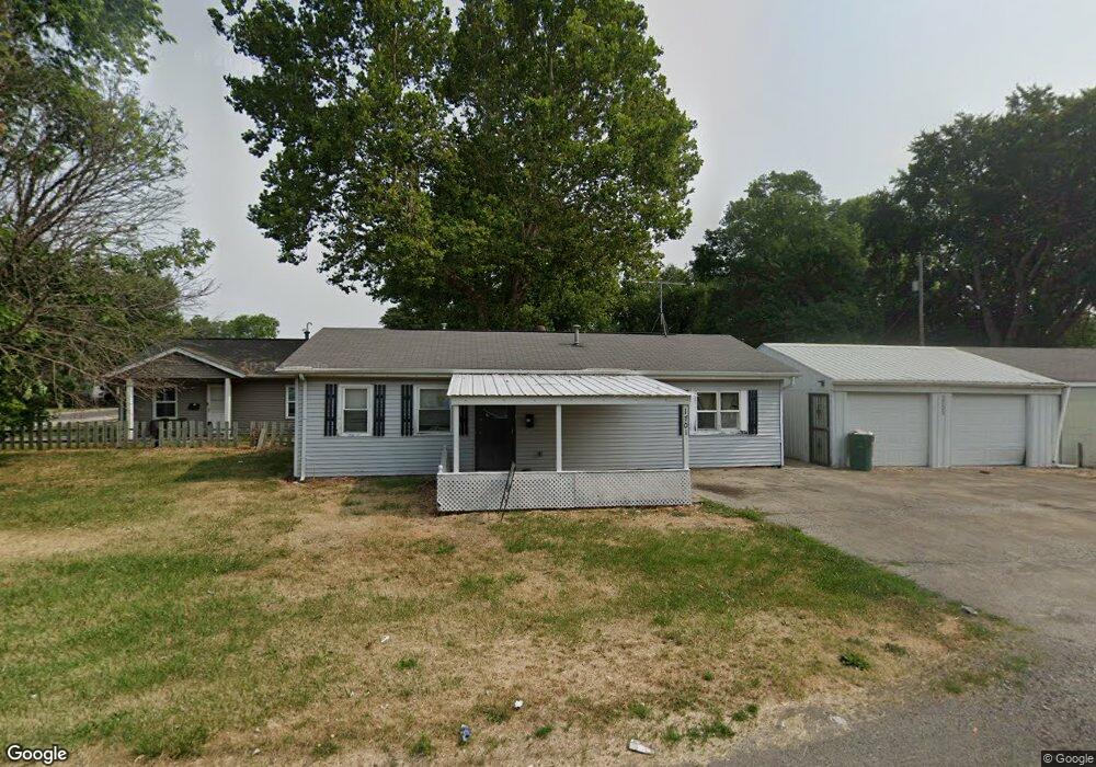
1701 E Spruce St Springfield, IL 62703
C Lee Carey Neighborhood Association NeighborhoodEstimated Value: $49,000 - $59,580
3
Beds
1
Bath
960
Sq Ft
$56/Sq Ft
Est. Value
About This Home
This home is located at 1701 E Spruce St, Springfield, IL 62703 and is currently estimated at $53,395, approximately $55 per square foot. 1701 E Spruce St is a home located in Sangamon County with nearby schools including Butler Elementary School, Benjamin Franklin Middle School, and Springfield Southeast High School.
Ownership History
Date
Name
Owned For
Owner Type
Purchase Details
Closed on
Jan 25, 2023
Sold by
Grasco Investments Llc
Bought by
Spruce Property Land Trust
Current Estimated Value
Purchase Details
Closed on
Apr 20, 2022
Sold by
James Forney
Bought by
Grasco Investments Llc
Home Financials for this Owner
Home Financials are based on the most recent Mortgage that was taken out on this home.
Original Mortgage
$46,750
Interest Rate
3.85%
Mortgage Type
New Conventional
Purchase Details
Closed on
Jun 15, 2021
Sold by
Land Trust
Bought by
Forney James
Purchase Details
Closed on
Aug 12, 2008
Purchase Details
Closed on
May 9, 2008
Purchase Details
Closed on
Nov 28, 2007
Purchase Details
Closed on
Jul 14, 2006
Purchase Details
Closed on
Mar 9, 2005
Purchase Details
Closed on
Jul 26, 1994
Create a Home Valuation Report for This Property
The Home Valuation Report is an in-depth analysis detailing your home's value as well as a comparison with similar homes in the area
Home Values in the Area
Average Home Value in this Area
Purchase History
| Date | Buyer | Sale Price | Title Company |
|---|---|---|---|
| Spruce Property Land Trust | -- | -- | |
| Grasco Investments Llc | $55,000 | Barber Segatto Hoffee Wilke & | |
| Forney James | -- | -- | |
| -- | $30,000 | -- | |
| -- | -- | -- | |
| -- | -- | -- | |
| -- | -- | -- | |
| -- | -- | -- | |
| -- | -- | -- |
Source: Public Records
Mortgage History
| Date | Status | Borrower | Loan Amount |
|---|---|---|---|
| Previous Owner | Grasco Investments Llc | $46,750 |
Source: Public Records
Tax History
| Year | Tax Paid | Tax Assessment Tax Assessment Total Assessment is a certain percentage of the fair market value that is determined by local assessors to be the total taxable value of land and additions on the property. | Land | Improvement |
|---|---|---|---|---|
| 2024 | $1,227 | $14,605 | $1,849 | $12,756 |
| 2023 | $1,179 | $13,340 | $1,689 | $11,651 |
| 2022 | $1,105 | $12,327 | $1,602 | $10,725 |
| 2021 | $1,014 | $11,266 | $1,543 | $9,723 |
| 2020 | $994 | $11,283 | $1,545 | $9,738 |
| 2019 | $975 | $11,244 | $1,540 | $9,704 |
| 2018 | $1,052 | $12,456 | $1,532 | $10,924 |
| 2017 | $1,031 | $12,295 | $1,512 | $10,783 |
| 2016 | $1,010 | $12,116 | $1,490 | $10,626 |
| 2015 | $1,001 | $11,971 | $1,472 | $10,499 |
| 2014 | $1,062 | $11,893 | $1,462 | $10,431 |
| 2013 | $1,038 | $12,810 | $1,463 | $11,347 |
Source: Public Records
Map
Nearby Homes
- 1909 E Cedar St
- 1838 S 19th St
- 2041 E Cedar St
- 2114 S Renfro St
- 2325 E Spruce St
- 1622 E Cornell Ave
- 1942 S 11th St
- 9 Alken Ct
- 2310 E Kansas St
- 1430 S 8th St
- 2205 S 11th St
- 2233 S 12th St
- 725 E Spruce St
- 1405 E Edwards St
- 6 Ridge Ct Unit 1
- Lot 1 & 2 Bunn Dr
- 2339 S 10th St
- 1105 Knoll Pointe Place
- 2324 S 8th St
- 718 S 7th St Unit 1003
- 1713 E Spruce St
- 1620 S 17th St
- 1616 S 17th St
- 1714 E Spruce St
- 1614 S 17th St
- 1629 S 17th St
- 1625 S 17th St
- 1621 S 17th St
- 1710 S 17th St
- 1716 S 17th St
- 1621 S Martin Luther King jr Dr
- 1615 S 17th St
- 1610 S 17th St
- 1625 S Martin Luther King Junior Dr
- 1621 S Martin Luther King Junior Dr
- 1611 S 17th St
- 1613 S Martin Luther King jr Dr Unit M
- 1609 S Martin Luther King jr Dr
- 1609 S Martin Luther King jr Dr Unit M
- 1705 S M l King Dr Unit M
Your Personal Tour Guide
Ask me questions while you tour the home.