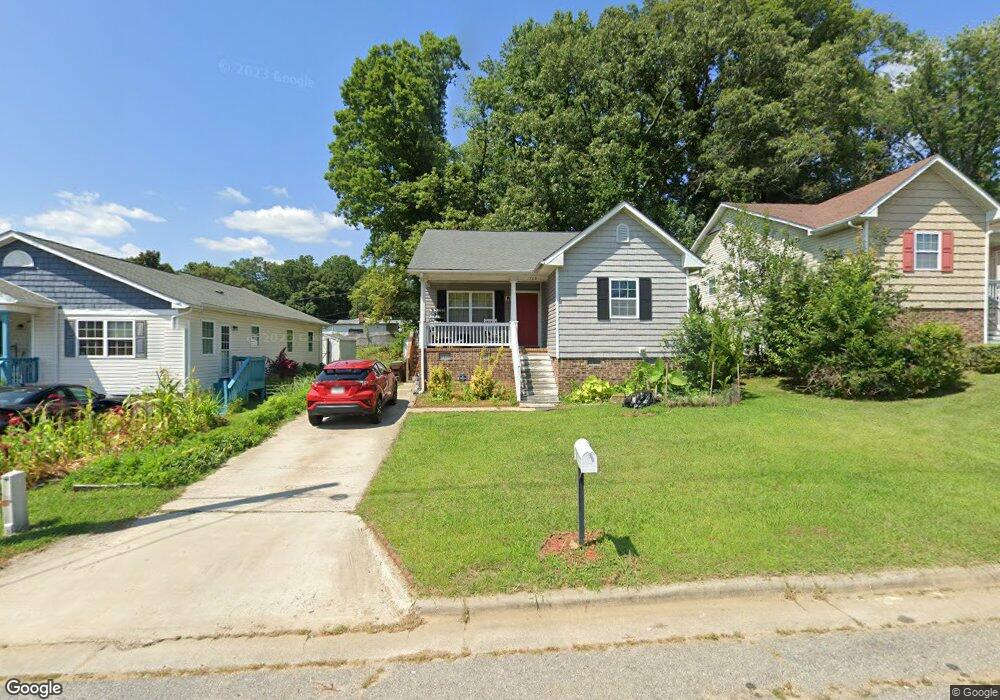
1703 Graves Ave High Point, NC 27260
Greater High Point NeighborhoodEstimated Value: $191,102 - $210,000
3
Beds
2
Baths
1,220
Sq Ft
$165/Sq Ft
Est. Value
About This Home
This home is located at 1703 Graves Ave, High Point, NC 27260 and is currently estimated at $201,026, approximately $164 per square foot. 1703 Graves Ave is a home with nearby schools including Parkview Village Elementary School, Southwest Guilford Middle School, and Southwest Guilford High School.
Ownership History
Date
Name
Owned For
Owner Type
Purchase Details
Closed on
Jun 2, 2009
Sold by
Habitat For Humanity Of High Point
Bought by
Rocham Chang and Rolan Hlel
Current Estimated Value
Home Financials for this Owner
Home Financials are based on the most recent Mortgage that was taken out on this home.
Original Mortgage
$30,000
Outstanding Balance
$14,688
Interest Rate
4.77%
Mortgage Type
Stand Alone Second
Estimated Equity
$186,338
Purchase Details
Closed on
Dec 3, 2007
Bought by
Habitat For Humanity Of High Point Archdale &
Create a Home Valuation Report for This Property
The Home Valuation Report is an in-depth analysis detailing your home's value as well as a comparison with similar homes in the area
Home Values in the Area
Average Home Value in this Area
Purchase History
| Date | Buyer | Sale Price | Title Company |
|---|---|---|---|
| Rocham Chang | $105,000 | None Available | |
| Habitat For Humanity Of High Point Archdale & | -- | -- |
Source: Public Records
Mortgage History
| Date | Status | Borrower | Loan Amount |
|---|---|---|---|
| Open | Rocham Chang | $30,000 | |
| Open | Rocham Chang | $75,000 |
Source: Public Records
Tax History
| Year | Tax Paid | Tax Assessment Tax Assessment Total Assessment is a certain percentage of the fair market value that is determined by local assessors to be the total taxable value of land and additions on the property. | Land | Improvement |
|---|---|---|---|---|
| 2025 | $1,717 | $124,600 | $14,000 | $110,600 |
| 2024 | $1,717 | $124,600 | $14,000 | $110,600 |
| 2023 | $1,717 | $124,600 | $14,000 | $110,600 |
| 2022 | $1,680 | $124,600 | $14,000 | $110,600 |
| 2021 | $1,328 | $96,400 | $9,000 | $87,400 |
| 2020 | $1,328 | $96,400 | $9,000 | $87,400 |
| 2019 | $1,328 | $96,400 | $0 | $0 |
| 2018 | $1,322 | $96,400 | $0 | $0 |
| 2017 | $1,322 | $96,400 | $0 | $0 |
| 2016 | $1,105 | $78,800 | $0 | $0 |
| 2015 | $1,111 | $78,800 | $0 | $0 |
| 2014 | $1,130 | $78,800 | $0 | $0 |
Source: Public Records
Map
Nearby Homes
- 1508 Boundary Ave
- 1602 Boundary Ave
- 1604 Boundary Ave
- 1606 Boundary Ave
- 1012 Meadowbrook Blvd
- 1308 Boundary Ave
- 511 Saunders Place Unit A & B
- 513 Saunders Place Unit A & B
- 205 Beach St
- 1504 East Ave
- 1506 East Ave
- 410 Meredith St
- 412 Meredith St
- 828 Circle Dr
- 1702 Brockett Ave
- 1707 Brockett Ave
- 1224 S Downing St
- 505 Kent Ct
- 230 Windley St
- 114 Eccles Place
- 1705 Graves Ave
- 1701 Graves Ave
- 1707 Graves Ave
- 220 Hoskins St
- 1502 Boundary Ave
- 1709 Graves Ave
- 1613 Graves Ave
- 1500 Boundary Ave
- 218 Hoskins St
- 317 Murray St
- 1414 Boundary Ave
- 1711 Graves Ave
- 1412 Boundary Ave
- 216 Hoskins St
- 1609 Graves Ave
- 221 Hoskins St
- 315 Murray St
- 1410 Boundary Ave
- 1510 Boundary Ave
- 214 Hoskins St
Your Personal Tour Guide
Ask me questions while you tour the home.