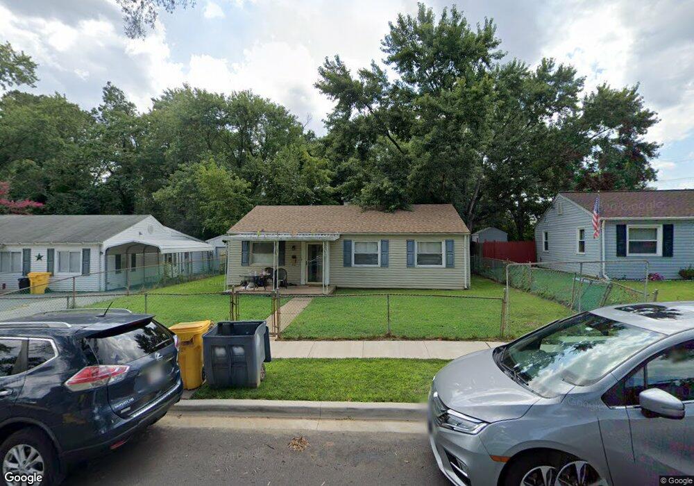
1705 Saunders Way Glen Burnie, MD 21061
Estimated Value: $289,000 - $324,000
--
Bed
1
Bath
988
Sq Ft
$312/Sq Ft
Est. Value
About This Home
This home is located at 1705 Saunders Way, Glen Burnie, MD 21061 and is currently estimated at $308,280, approximately $312 per square foot. 1705 Saunders Way is a home located in Anne Arundel County with nearby schools including Woodside Elementary School, Corkran Middle School, and Glen Burnie High School.
Ownership History
Date
Name
Owned For
Owner Type
Purchase Details
Closed on
Jul 12, 2004
Sold by
Yirka Jonathan J
Bought by
Roland Ii Charles W and Peyatt Lynn
Current Estimated Value
Purchase Details
Closed on
Sep 30, 1998
Sold by
Susquehanna Bank
Bought by
Yirka Jonathan J and Runk Jessica A
Purchase Details
Closed on
Mar 10, 1998
Sold by
Alder Howard D
Bought by
Susquehanna Bank
Create a Home Valuation Report for This Property
The Home Valuation Report is an in-depth analysis detailing your home's value as well as a comparison with similar homes in the area
Home Values in the Area
Average Home Value in this Area
Purchase History
| Date | Buyer | Sale Price | Title Company |
|---|---|---|---|
| Roland Ii Charles W | $165,900 | -- | |
| Yirka Jonathan J | $89,900 | -- | |
| Susquehanna Bank | $70,000 | -- |
Source: Public Records
Mortgage History
| Date | Status | Borrower | Loan Amount |
|---|---|---|---|
| Closed | Roland Ii Charles W | -- |
Source: Public Records
Tax History Compared to Growth
Tax History
| Year | Tax Paid | Tax Assessment Tax Assessment Total Assessment is a certain percentage of the fair market value that is determined by local assessors to be the total taxable value of land and additions on the property. | Land | Improvement |
|---|---|---|---|---|
| 2025 | $2,319 | $220,800 | $142,700 | $78,100 |
| 2024 | $2,319 | $207,367 | $0 | $0 |
| 2023 | $1,765 | $193,933 | $0 | $0 |
| 2022 | $2,077 | $180,500 | $112,700 | $67,800 |
| 2021 | $4,089 | $176,533 | $0 | $0 |
| 2020 | $1,971 | $172,567 | $0 | $0 |
| 2019 | $1,941 | $168,600 | $102,700 | $65,900 |
| 2018 | $1,679 | $165,567 | $0 | $0 |
| 2017 | $1,837 | $162,533 | $0 | $0 |
| 2016 | -- | $159,500 | $0 | $0 |
| 2015 | -- | $151,100 | $0 | $0 |
| 2014 | -- | $142,700 | $0 | $0 |
Source: Public Records
Map
Nearby Homes
- 1702 Manning Rd
- 1612 Lorimer Rd
- 8918 Twin Ridge Dr
- 1731 Saunders Way
- 8903 Jeff Mar Dr
- 1701 Norfolk Rd
- 8906 Jeff Mar Dr
- 405 Morningside Dr
- 1921 Norwich Rd
- 1003 Lee Rd
- 1613 Kimber Rd
- 1909 Pagham Rd
- 338 White Oak Way
- 0 Irene Dr
- 301 Whitman Ct
- 180 Jessica Ln
- 251 Oakview Village Dr
- 7818 Oakwood Rd
- 1318 Tarrant Rd
- 307 Oxford Dr
- 1703 Saunders Way
- 1707 Saunders Way
- 1709 Saunders Way
- 1701 Saunders Way
- 1704 Saunders Way
- 1706 Saunders Way
- 1702 Saunders Way
- 1711 Saunders Way
- 1708 Saunders Way
- 1700 Saunders Way
- 1710 Saunders Way
- 1713 Saunders Way
- 1707 Manning Rd
- 1609 Saunders Way
- 1709 Manning Rd
- 1705 Manning Rd
- 525 Morningside Dr
- 1703 Manning Rd
- 1712 Saunders Way
- 610 Oakwood Station Rd