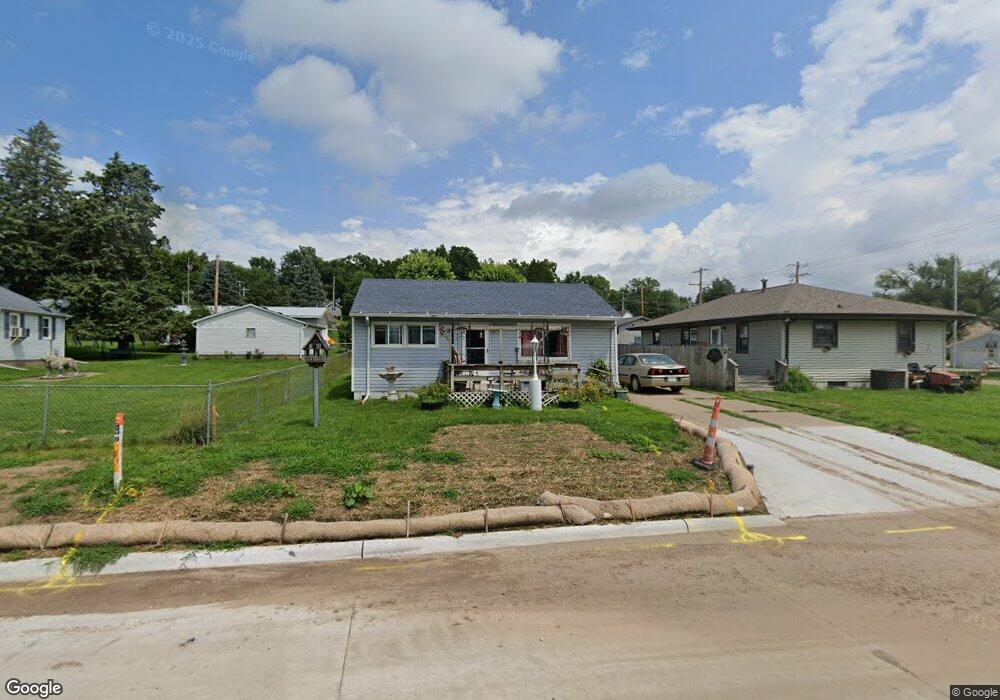
1706 13th Ave S Clinton, IA 52732
Estimated Value: $76,000 - $99,000
3
Beds
2
Baths
980
Sq Ft
$90/Sq Ft
Est. Value
About This Home
This home is located at 1706 13th Ave S, Clinton, IA 52732 and is currently estimated at $88,595, approximately $90 per square foot. 1706 13th Ave S is a home located in Clinton County with nearby schools including Bluff Elementary School, Clinton Middle School, and Clinton High School.
Ownership History
Date
Name
Owned For
Owner Type
Purchase Details
Closed on
Jun 2, 2025
Sold by
Elvira Cemetery Association
Bought by
Ridebach Laurie and Guidebeck Stephen P
Current Estimated Value
Purchase Details
Closed on
Nov 4, 2008
Sold by
Garien Leanda A and Bark Duane E
Bought by
Bark Leanda M and Bark Duane E
Home Financials for this Owner
Home Financials are based on the most recent Mortgage that was taken out on this home.
Original Mortgage
$69,088
Interest Rate
6.09%
Mortgage Type
FHA
Create a Home Valuation Report for This Property
The Home Valuation Report is an in-depth analysis detailing your home's value as well as a comparison with similar homes in the area
Home Values in the Area
Average Home Value in this Area
Purchase History
| Date | Buyer | Sale Price | Title Company |
|---|---|---|---|
| Ridebach Laurie | -- | None Listed On Document | |
| Bark Leanda M | -- | None Available |
Source: Public Records
Mortgage History
| Date | Status | Borrower | Loan Amount |
|---|---|---|---|
| Previous Owner | Bark Leanda M | $69,088 |
Source: Public Records
Tax History Compared to Growth
Tax History
| Year | Tax Paid | Tax Assessment Tax Assessment Total Assessment is a certain percentage of the fair market value that is determined by local assessors to be the total taxable value of land and additions on the property. | Land | Improvement |
|---|---|---|---|---|
| 2025 | $1,066 | $66,990 | $8,400 | $58,590 |
| 2024 | $1,066 | $67,530 | $8,400 | $59,130 |
| 2023 | $1,046 | $67,530 | $8,400 | $59,130 |
| 2022 | $956 | $52,706 | $6,916 | $45,790 |
| 2021 | $1,018 | $52,706 | $6,916 | $45,790 |
| 2020 | $1,018 | $52,706 | $6,916 | $45,790 |
| 2019 | $1,052 | $52,706 | $0 | $0 |
| 2018 | $1,020 | $52,706 | $0 | $0 |
| 2017 | $1,054 | $52,706 | $0 | $0 |
| 2016 | $1,016 | $52,706 | $0 | $0 |
| 2015 | $1,016 | $52,706 | $0 | $0 |
| 2014 | $1,020 | $52,706 | $0 | $0 |
| 2013 | $1,002 | $0 | $0 | $0 |
Source: Public Records
Map
Nearby Homes
- 1908 Circle Dr S
- 819 Millcrest Ct
- 1331 15th Ave S Unit South
- 1510 7th Ave S
- 1400 8th Ave S
- 1239 14th Ave S
- 1313 Harrison Dr
- 716 Terrace Dr
- 1305 Harrison Dr
- 1836 Zara Trace
- 1830 Zara Trace
- 1824 Zara Trace
- 1818 Zara Trace
- 1825 5th Ave S
- 1214 S 12th St
- 1315 Caroline Ave
- 1216 9th Ave S
- 1813 Zara Trace St
- 1201 9th Ave S
- 1865 Harrison Dr
- 1720 13th Ave S
- 1712 13th Ave S
- 1715 13th Ave S
- 1707 13th Ave S
- 1212 S 17th St
- 1724 S Bluff Blvd
- 1725 13th Ave S
- 1721 13th Ave S
- 1730 S Bluff Blvd
- 1735 13th Ave S
- 1729 13th Ave S
- 1707 S Bluff Blvd
- 1712 S Bluff Blvd
- 1041 College Ave
- 1312 S 17th St
- 1734 S Bluff Blvd
- 1642 13th Ave S
- 1644 13th Ave S
- 1038 College Ave
- 1647 13th Ave S