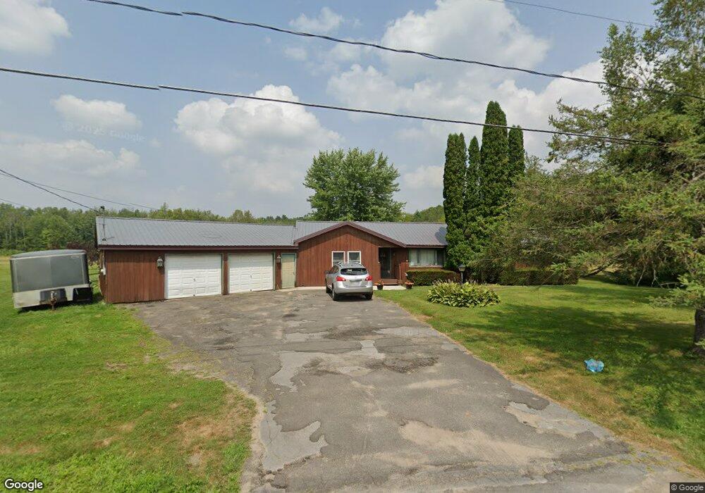
1706 County Route 45 Fulton, NY 13069
Estimated Value: $215,922 - $240,000
3
Beds
1
Bath
1,624
Sq Ft
$141/Sq Ft
Est. Value
About This Home
This home is located at 1706 County Route 45, Fulton, NY 13069 and is currently estimated at $229,231, approximately $141 per square foot. 1706 County Route 45 is a home located in Oswego County with nearby schools including Mexico High School.
Ownership History
Date
Name
Owned For
Owner Type
Purchase Details
Closed on
May 7, 2025
Sold by
Kellar Mark W and Hopp Lindsay B
Bought by
Hopp Lindsay B and Hopp Jeffrey W
Current Estimated Value
Purchase Details
Closed on
May 24, 2005
Sold by
Austic Mary K
Bought by
Kellar Lindsay B and Kellar Mark W
Home Financials for this Owner
Home Financials are based on the most recent Mortgage that was taken out on this home.
Original Mortgage
$76,792
Interest Rate
5.94%
Mortgage Type
FHA
Purchase Details
Closed on
Apr 22, 1999
Create a Home Valuation Report for This Property
The Home Valuation Report is an in-depth analysis detailing your home's value as well as a comparison with similar homes in the area
Home Values in the Area
Average Home Value in this Area
Purchase History
| Date | Buyer | Sale Price | Title Company |
|---|---|---|---|
| Hopp Lindsay B | $7,190 | Vanguard Research & Ttl Svcs | |
| Kellar Lindsay B | $74,000 | Ticor | |
| Kellar Lindsay B | $74,000 | Ticor | |
| -- | -- | -- | |
| -- | -- | -- |
Source: Public Records
Mortgage History
| Date | Status | Borrower | Loan Amount |
|---|---|---|---|
| Previous Owner | Kellar Lindsay B | $76,792 |
Source: Public Records
Tax History Compared to Growth
Tax History
| Year | Tax Paid | Tax Assessment Tax Assessment Total Assessment is a certain percentage of the fair market value that is determined by local assessors to be the total taxable value of land and additions on the property. | Land | Improvement |
|---|---|---|---|---|
| 2024 | $4,750 | $147,000 | $16,000 | $131,000 |
| 2023 | $3,906 | $147,000 | $16,000 | $131,000 |
| 2022 | $3,906 | $147,000 | $16,000 | $131,000 |
| 2021 | $3,906 | $98,000 | $15,100 | $82,900 |
| 2020 | $3,161 | $98,000 | $15,100 | $82,900 |
| 2019 | $3,161 | $98,000 | $15,100 | $82,900 |
| 2018 | $3,161 | $98,000 | $15,100 | $82,900 |
| 2017 | $3,332 | $98,000 | $15,100 | $82,900 |
| 2016 | $3,397 | $98,000 | $15,100 | $82,900 |
| 2015 | -- | $95,000 | $15,100 | $79,900 |
| 2014 | -- | $95,000 | $15,100 | $79,900 |
Source: Public Records
Map
Nearby Homes
- 13 Clifford Rd
- 210 Goodfellow Rd Unit 16
- 4375 State Route 3
- 2130 County Route 45
- 393 County Route 35
- 5264 State Route 49
- 1628 County Route 6
- 2410 County Route 6
- 1572 County Route 6
- 4883 State Route 3
- 59 Graves Rd
- 2922 County Route 4
- 0 County Route 45
- 798 Silk Rd
- 4384 State Route 49
- 174 Pople Ridge Rd
- 0 Emery Rd Unit S1580786
- 3119 County Route 4
- 115 Weller Rd
- 178 Green Rd
- 1709 County Route 45
- 1699 County Route 45
- 1728 County Route 45
- 1678 County Route 45
- 1681 County Route 45
- 4107 State Route 3
- 1668 County Route 45
- 1747 County Route 45
- 4101 State Route 3
- 4071 State Route 3
- 000 State Rt 3
- 1004 Co Rt 45
- 1004 County Route 45
- 4111 State Route 3
- 4069 State Route 3
- 3 County Route 35
- 4092 State Route 3
- 4100 State Route 3
- 4055 State Route 3
- 1753 County Route 45