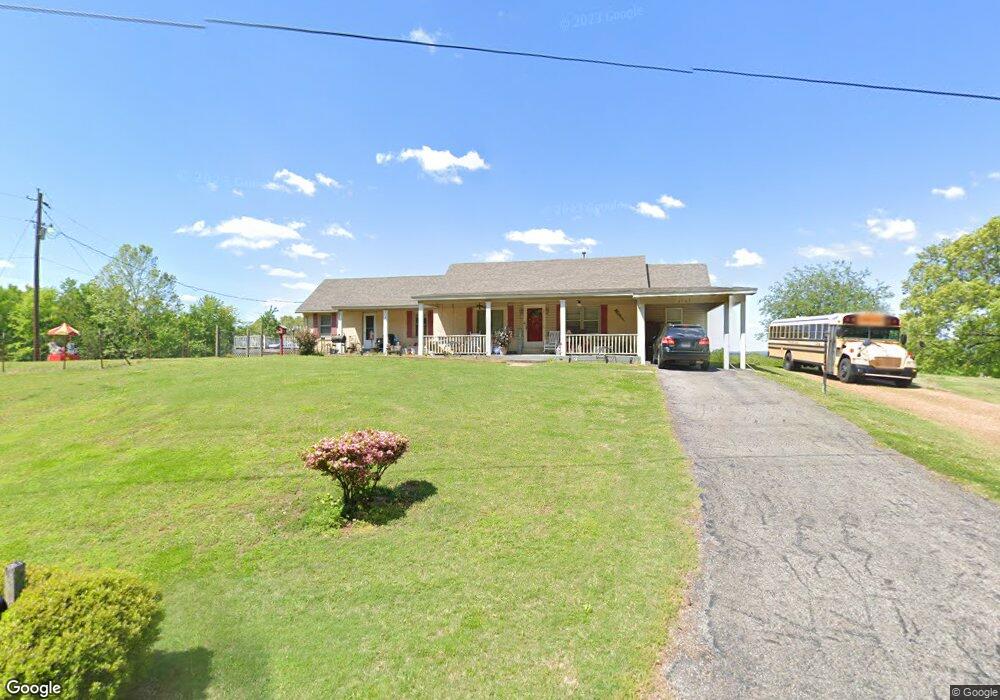
1707 Mt Lebanon Rd Covington, TN 38019
Estimated Value: $244,000 - $286,000
--
Bed
2
Baths
1,885
Sq Ft
$137/Sq Ft
Est. Value
About This Home
This home is located at 1707 Mt Lebanon Rd, Covington, TN 38019 and is currently estimated at $258,129, approximately $136 per square foot. 1707 Mt Lebanon Rd is a home located in Tipton County with nearby schools including Crestview Elementary School, Crestview Middle School, and Covington High School.
Ownership History
Date
Name
Owned For
Owner Type
Purchase Details
Closed on
Jun 12, 2001
Bought by
Loyed Robert E and Loyed Charlotte
Current Estimated Value
Home Financials for this Owner
Home Financials are based on the most recent Mortgage that was taken out on this home.
Original Mortgage
$95,247
Outstanding Balance
$36,281
Interest Rate
7.14%
Estimated Equity
$221,848
Purchase Details
Closed on
Mar 12, 1982
Bought by
Williams Robert David and Shirley Jea
Purchase Details
Closed on
May 22, 1980
Create a Home Valuation Report for This Property
The Home Valuation Report is an in-depth analysis detailing your home's value as well as a comparison with similar homes in the area
Home Values in the Area
Average Home Value in this Area
Purchase History
| Date | Buyer | Sale Price | Title Company |
|---|---|---|---|
| Loyed Robert E | $96,000 | -- | |
| Williams Robert David | -- | -- | |
| -- | -- | -- |
Source: Public Records
Mortgage History
| Date | Status | Borrower | Loan Amount |
|---|---|---|---|
| Open | Not Available | $95,247 |
Source: Public Records
Tax History Compared to Growth
Tax History
| Year | Tax Paid | Tax Assessment Tax Assessment Total Assessment is a certain percentage of the fair market value that is determined by local assessors to be the total taxable value of land and additions on the property. | Land | Improvement |
|---|---|---|---|---|
| 2024 | $786 | $51,675 | $9,725 | $41,950 |
| 2023 | $786 | $51,675 | $9,725 | $41,950 |
| 2022 | $751 | $36,800 | $7,150 | $29,650 |
| 2021 | $751 | $36,800 | $7,150 | $29,650 |
| 2020 | $627 | $36,800 | $7,150 | $29,650 |
| 2019 | $708 | $29,275 | $6,125 | $23,150 |
| 2018 | $708 | $29,275 | $6,125 | $23,150 |
| 2017 | $708 | $29,275 | $6,125 | $23,150 |
| 2016 | $708 | $29,275 | $6,125 | $23,150 |
| 2015 | $708 | $29,275 | $6,125 | $23,150 |
| 2014 | $708 | $29,287 | $0 | $0 |
Source: Public Records
Map
Nearby Homes
- 1202 Bucksnort Rd
- 101 Sivil Cir
- 0 Millstone Mountain Rd
- 1524 Garland Dr
- 65 Paulette Cir
- 73 Mcwilliams Rd
- 902 Hatchie Ave
- 900 Peete St
- 924 W Liberty Ave
- LOT 5 Wortham Dr
- LOT 4 Wortham Dr
- 000 Davis St
- 1517 Michael St
- 1186 U S 51
- 117 E Ripley Ave
- 273 Daniel Dr
- 0 U S 51 S
- 0 Hwy 51
- 0 N Munford St Unit 10156264
- 0 N Munford St Unit 10156263
- 1756 Mt Lebanon Rd
- 1759 Mt Lebanon Rd
- 1774 Mt Lebanon Rd
- 1607 Mt Lebanon Rd
- 180 Cromwell Rd
- 1872 Mount Lebanon Rd
- 1554 Mt Lebanon Rd
- 1510 Mt Lebanon Rd
- 248 Cromwell Rd
- 2001 Mt Lebanon Rd
- 97 Bride Ln
- 1440 Mt Lebanon Rd
- 0 Bride Ln
- 00 Bride Ln
- 1431 Mt Lebanon Rd
- 2037 Mt Lebanon Rd
- 2061 Mt Lebanon Rd
- 1362 Mt Lebanon Rd
- 80 Bride Ln
- 157 Bride Ln