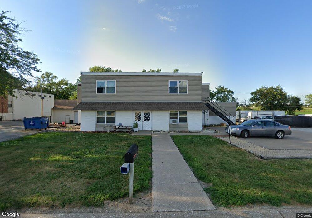
17070 215th St Davenport, IA 52806
Outer Davenport/Bettendorf NeighborhoodEstimated Value: $226,000
--
Bed
--
Bath
4,480
Sq Ft
$50/Sq Ft
Est. Value
About This Home
This home is located at 17070 215th St, Davenport, IA 52806 and is currently priced at $226,000, approximately $50 per square foot. 17070 215th St is a home located in Scott County with nearby schools including Alan Shepard Elementary School, North Scott Junior High School, and North Scott Senior High School.
Ownership History
Date
Name
Owned For
Owner Type
Purchase Details
Closed on
Nov 15, 2011
Sold by
Wells Fargo Bank Na
Bought by
Enchanted Island Inn Llc
Current Estimated Value
Purchase Details
Closed on
Aug 9, 2011
Sold by
Ahlers Concrete Construction and Ahlers Robert W
Bought by
Wells Fargo Bank Na
Create a Home Valuation Report for This Property
The Home Valuation Report is an in-depth analysis detailing your home's value as well as a comparison with similar homes in the area
Home Values in the Area
Average Home Value in this Area
Purchase History
| Date | Buyer | Sale Price | Title Company |
|---|---|---|---|
| Enchanted Island Inn Llc | $80,000 | None Available | |
| Wells Fargo Bank Na | $85,000 | None Available |
Source: Public Records
Tax History Compared to Growth
Tax History
| Year | Tax Paid | Tax Assessment Tax Assessment Total Assessment is a certain percentage of the fair market value that is determined by local assessors to be the total taxable value of land and additions on the property. | Land | Improvement |
|---|---|---|---|---|
| 2025 | $3,838 | $285,900 | $92,300 | $193,600 |
| 2024 | $3,830 | $248,000 | $61,500 | $186,500 |
| 2023 | $3,852 | $248,000 | $61,500 | $186,500 |
| 2022 | $3,450 | $244,420 | $36,500 | $207,920 |
| 2021 | $3,450 | $244,420 | $36,500 | $207,920 |
| 2020 | $3,130 | $224,940 | $36,500 | $188,440 |
| 2019 | $3,036 | $224,940 | $36,500 | $188,440 |
| 2018 | $3,198 | $224,940 | $36,500 | $188,440 |
| 2017 | $3,120 | $224,940 | $36,500 | $188,440 |
| 2016 | $3,106 | $223,440 | $0 | $0 |
| 2015 | $3,222 | $208,820 | $0 | $0 |
| 2014 | $4,688 | $208,820 | $0 | $0 |
| 2013 | $5,008 | $0 | $0 | $0 |
| 2012 | -- | $200,590 | $43,800 | $156,790 |
Source: Public Records
Map
Nearby Homes
- 20664 N Brady St
- 0 Research Pkwy Unit LOT 1
- 0 Research Pkwy Unit 11
- Lot 28 Linden Ln
- 1704 Redbud Cir Unit 101
- 1704 Redbud Cir Unit 103
- 1704 Redbud Cir Unit 102
- Lot 22 S 5th St
- 1719 S 5th St
- 1867 Redbud Cir Unit 103
- 1832 Redbud Cir
- 1875 Redbud Cir Unit 101
- 1867 Redbud Cir Unit 102
- 1867 Redbud Cir Unit 101
- 1875 Redbud Cir Unit 102
- 1875 Redbud Cir Unit 103
- 0 215th Unit 4149218
- 17088 214th St Unit 17101
- 17060 214th St
- 17055 214th St
- 17095 214th St
- 17125 214th St
- 17190 214th St
- 21340 N Brady St Unit A-1
- 21340 N Brady St Unit b-3
- 21340 N Brady St Unit 4
- 21340 N Brady St Unit 2
- 21340 N Brady St
- 21340 N Brady St Unit 1&2
- 21340 N Brady St Unit 1
- 21340 N Brady St Unit 1&A
- 0 214th Unit 7037820
- 0 214th Unit 7036899
- 21355 N Brady St
- 0 Scott Park Rd Unit 7030760
- 0 Scott Park Rd Unit 4132099