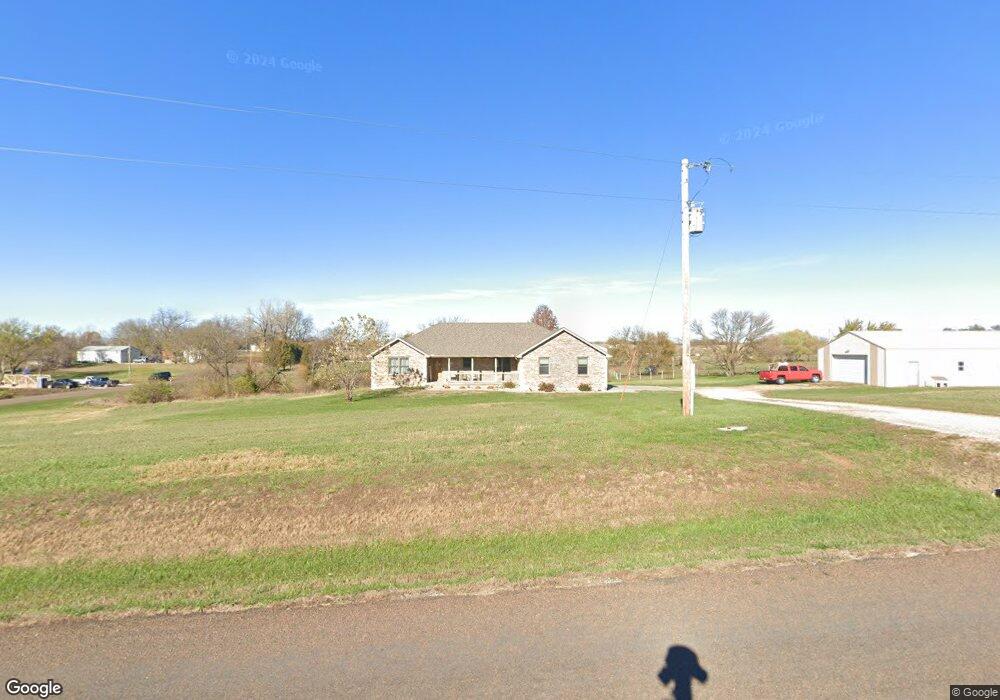
17070 Gilman Rd Leavenworth, KS 66048
Estimated Value: $589,000 - $606,810
3
Beds
3
Baths
2,392
Sq Ft
$250/Sq Ft
Est. Value
About This Home
This home is located at 17070 Gilman Rd, Leavenworth, KS 66048 and is currently estimated at $598,603, approximately $250 per square foot. 17070 Gilman Rd is a home located in Leavenworth County with nearby schools including Lansing Elementary School, Lansing Middle 6-8, and Lansing High 9-12.
Ownership History
Date
Name
Owned For
Owner Type
Purchase Details
Closed on
Nov 1, 2004
Bought by
Foley Adam M and Foley Cari D
Current Estimated Value
Home Financials for this Owner
Home Financials are based on the most recent Mortgage that was taken out on this home.
Original Mortgage
$25,000
Outstanding Balance
$16,667
Interest Rate
5.64%
Mortgage Type
New Conventional
Estimated Equity
$581,936
Create a Home Valuation Report for This Property
The Home Valuation Report is an in-depth analysis detailing your home's value as well as a comparison with similar homes in the area
Home Values in the Area
Average Home Value in this Area
Purchase History
| Date | Buyer | Sale Price | Title Company |
|---|---|---|---|
| Foley Adam M | $53,000 | -- |
Source: Public Records
Mortgage History
| Date | Status | Borrower | Loan Amount |
|---|---|---|---|
| Open | Foley Adam M | $25,000 | |
| Closed | Foley Adam M | $240,900 |
Source: Public Records
Tax History Compared to Growth
Tax History
| Year | Tax Paid | Tax Assessment Tax Assessment Total Assessment is a certain percentage of the fair market value that is determined by local assessors to be the total taxable value of land and additions on the property. | Land | Improvement |
|---|---|---|---|---|
| 2025 | $6,976 | $63,261 | $8,280 | $54,981 |
| 2024 | $6,550 | $60,961 | $7,573 | $53,388 |
| 2023 | $6,550 | $60,053 | $7,567 | $52,486 |
| 2022 | $6,437 | $56,970 | $6,476 | $50,494 |
| 2021 | $5,579 | $48,905 | $5,612 | $43,293 |
| 2020 | $5,284 | $45,581 | $5,389 | $40,192 |
| 2019 | $5,089 | $43,827 | $5,038 | $38,789 |
| 2018 | $4,837 | $41,698 | $4,112 | $37,586 |
| 2017 | $4,725 | $40,599 | $3,933 | $36,666 |
| 2016 | $4,648 | $40,000 | $3,873 | $36,127 |
| 2015 | $4,460 | $38,541 | $3,870 | $34,671 |
| 2014 | $4,287 | $37,715 | $3,954 | $33,761 |
Source: Public Records
Map
Nearby Homes
- 25770 Tonganoxie Dr
- 16430 Dana Ln
- 25030 177th Terrace
- 24450 171st St
- 25055 Woodridge Cir
- 17860 Clearview Dr
- Lot 6 163rd St
- 00000 Gilman Rd
- 17739 Eisenhower Rd
- 26277 187th St
- 17096 Eisenhower Rd
- 0000 Eisenhower Rd
- 16055 W Eisenhower Rd
- 15915 Eisenhower Rd
- 1221 S Desoto Rd
- 000 4-H Rd
- 15280 Roger Rd
- 833 Rock Creek Dr
- 811 4-H Rd
- 875 Clearview Dr
- 25290 171st St
- 25281 171st St
- 25312 171st St
- 25382 171st St
- 16930 Gilman Rd
- 25341 171st St
- 25103 171st St
- 25392 171st St
- 25455 171st St
- 25530 Tonganoxie Dr
- 25310 Tonganoxie Rd
- 25488 Tonganoxie Rd
- 25442 Tonganoxie Rd
- 17159 4h Rd
- 00000 Tonganoxie Dr
- 25420 Tonganoxie Rd
- 16661 Gilman Rd
- 16698 Dana Ln
- 25126 Tonganoxie Dr
- 25374 Tonganoxie Rd