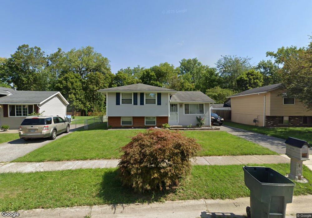
1708 Creekside Dr Columbus, OH 43223
Riverbend NeighborhoodEstimated Value: $242,000 - $262,000
3
Beds
2
Baths
1,444
Sq Ft
$175/Sq Ft
Est. Value
About This Home
This home is located at 1708 Creekside Dr, Columbus, OH 43223 and is currently estimated at $252,924, approximately $175 per square foot. 1708 Creekside Dr is a home located in Franklin County with nearby schools including James A Harmon Elementary School, Franklin Woods Intermediate School, and Finland Middle School.
Ownership History
Date
Name
Owned For
Owner Type
Purchase Details
Closed on
Jan 27, 2020
Sold by
Estate Of John Lee Simons
Bought by
Lones Michael S
Current Estimated Value
Purchase Details
Closed on
Apr 18, 2003
Sold by
Gates Ralph L and Gates Sherry J
Bought by
Simons John L and Simons Rebecca A
Home Financials for this Owner
Home Financials are based on the most recent Mortgage that was taken out on this home.
Original Mortgage
$102,682
Interest Rate
5.71%
Mortgage Type
FHA
Purchase Details
Closed on
May 2, 1995
Sold by
Painter Jeffrey W
Bought by
Gates Ralph L and Gates Sherry J
Home Financials for this Owner
Home Financials are based on the most recent Mortgage that was taken out on this home.
Original Mortgage
$83,900
Interest Rate
8.5%
Mortgage Type
VA
Create a Home Valuation Report for This Property
The Home Valuation Report is an in-depth analysis detailing your home's value as well as a comparison with similar homes in the area
Home Values in the Area
Average Home Value in this Area
Purchase History
| Date | Buyer | Sale Price | Title Company |
|---|---|---|---|
| Lones Michael S | -- | None Available | |
| Simons John L | $104,400 | Stewart Title Agency Of Colu | |
| Gates Ralph L | $81,500 | -- |
Source: Public Records
Mortgage History
| Date | Status | Borrower | Loan Amount |
|---|---|---|---|
| Previous Owner | Simons John L | $102,682 | |
| Previous Owner | Gates Ralph L | $83,900 |
Source: Public Records
Tax History Compared to Growth
Tax History
| Year | Tax Paid | Tax Assessment Tax Assessment Total Assessment is a certain percentage of the fair market value that is determined by local assessors to be the total taxable value of land and additions on the property. | Land | Improvement |
|---|---|---|---|---|
| 2024 | $2,568 | $70,420 | $20,510 | $49,910 |
| 2023 | $2,522 | $70,420 | $20,510 | $49,910 |
| 2022 | $2,069 | $42,390 | $11,800 | $30,590 |
| 2021 | $2,110 | $42,390 | $11,800 | $30,590 |
| 2020 | $2,098 | $42,390 | $11,800 | $30,590 |
| 2019 | $2,142 | $34,580 | $9,800 | $24,780 |
| 2018 | $965 | $34,580 | $9,800 | $24,780 |
| 2017 | $1,922 | $34,580 | $9,800 | $24,780 |
| 2016 | $1,753 | $28,980 | $5,670 | $23,310 |
| 2015 | $877 | $28,980 | $5,670 | $23,310 |
| 2014 | $1,755 | $28,980 | $5,670 | $23,310 |
| 2013 | $967 | $32,200 | $6,300 | $25,900 |
Source: Public Records
Map
Nearby Homes
- 2800 Alkire Rd
- 1520 Fall Brook Rd
- 0 Glencreek Rd
- 2894 Creith Ct
- 2195 Big Run Ave
- 3326 Bluhm Ct
- 2930 Alkire Rd
- 2937 Rundell Dr
- 2255 Harrisburg Pike
- 2856 Chesfield Dr
- 1465 Tall Meadows Dr
- 3206 Andy Terrace
- 1657 Ripplebrook Rd
- 2103 Keller Place W
- 2929 Briggs Rd
- 3488 Rocky Rd
- 1168 Racine Ave
- 1147 Parma Ave
- 1181 Onslow Dr
- 0 S Central Ave
- 1704 Creekside Dr
- 1720 Creekside Dr
- 1714 Creekside Dr
- 1700 Creekside Dr
- 1715 Creekside Dr
- 1709 Creekside Dr
- 1719 Creekside Dr Unit ROCK
- 1719 Creekside Dr
- 1728 Creekside Dr
- 1696 Creekside Dr
- 1725 Creekside Dr
- 1705 Creekside Dr Unit ROCK
- 1705 Creekside Dr
- 1701 Creekside Dr
- 1692 Creekside Dr
- 1734 Creekside Dr
- 1737 Creekside Dr
- 3048 Musket Ridge Dr
- 1697 Creekside Dr
- 1688 Creekside Dr