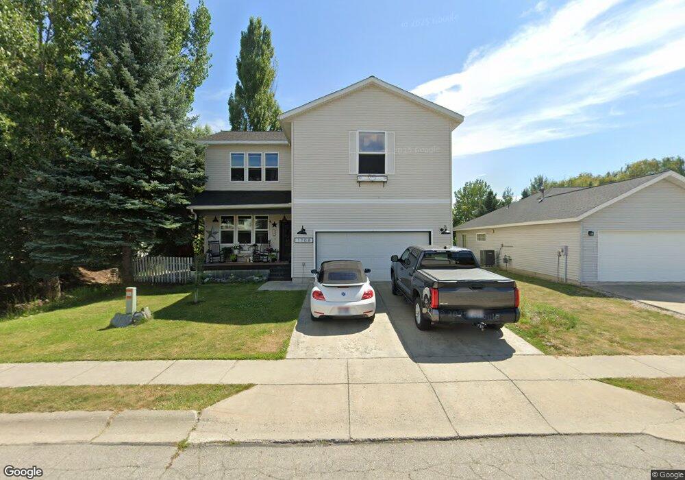
1708 Northshore Dr Sandpoint, ID 83864
Estimated Value: $627,000 - $713,579
4
Beds
3
Baths
2,434
Sq Ft
$278/Sq Ft
Est. Value
About This Home
This home is located at 1708 Northshore Dr, Sandpoint, ID 83864 and is currently estimated at $677,645, approximately $278 per square foot. 1708 Northshore Dr is a home located in Bonner County with nearby schools including Washington Elementary School, Sandpoint Middle School, and Sandpoint High School.
Ownership History
Date
Name
Owned For
Owner Type
Purchase Details
Closed on
Apr 16, 2018
Sold by
Cooney Rebecca L and Moss Rebecca L
Bought by
Moss George Derek
Current Estimated Value
Home Financials for this Owner
Home Financials are based on the most recent Mortgage that was taken out on this home.
Original Mortgage
$330,500
Outstanding Balance
$283,613
Interest Rate
4.44%
Mortgage Type
New Conventional
Estimated Equity
$394,032
Purchase Details
Closed on
Dec 15, 2006
Sold by
Vandenberg Gerald D and Beyer Sally
Bought by
Vandenberg Jay D and Beyer Sally F
Home Financials for this Owner
Home Financials are based on the most recent Mortgage that was taken out on this home.
Original Mortgage
$670,000
Interest Rate
6.33%
Mortgage Type
Future Advance Clause Open End Mortgage
Create a Home Valuation Report for This Property
The Home Valuation Report is an in-depth analysis detailing your home's value as well as a comparison with similar homes in the area
Home Values in the Area
Average Home Value in this Area
Purchase History
| Date | Buyer | Sale Price | Title Company |
|---|---|---|---|
| Moss George Derek | -- | Kootenai County Title Co | |
| Vandenberg Jay D | -- | -- |
Source: Public Records
Mortgage History
| Date | Status | Borrower | Loan Amount |
|---|---|---|---|
| Open | Moss George Derek | $330,500 | |
| Previous Owner | Vandenberg Jay D | $670,000 |
Source: Public Records
Tax History Compared to Growth
Tax History
| Year | Tax Paid | Tax Assessment Tax Assessment Total Assessment is a certain percentage of the fair market value that is determined by local assessors to be the total taxable value of land and additions on the property. | Land | Improvement |
|---|---|---|---|---|
| 2025 | $3,571 | $659,609 | $263,849 | $395,760 |
| 2024 | $3,826 | $673,429 | $263,849 | $409,580 |
| 2023 | $3,046 | $685,393 | $263,849 | $421,544 |
| 2022 | $3,304 | $569,041 | $185,986 | $383,055 |
| 2021 | $3,334 | $425,910 | $179,783 | $246,127 |
| 2020 | $3,132 | $387,712 | $136,564 | $251,148 |
| 2019 | $4,036 | $354,056 | $115,944 | $238,112 |
| 2018 | $3,974 | $327,808 | $115,944 | $211,864 |
| 2017 | $3,974 | $307,242 | $0 | $0 |
| 2016 | $3,733 | $275,408 | $0 | $0 |
| 2015 | $3,838 | $281,658 | $0 | $0 |
| 2014 | $3,680 | $273,598 | $0 | $0 |
Source: Public Records
Map
Nearby Homes
- 1515 Northshore Dr
- 1721 Northshore Dr
- 1020 Park Ave
- 1309 Westwood Ln
- 1406 J r Ct
- 1410 J r Ct
- 1405 Autumn Ln
- 1320 Mathison Dr
- 704 S Merton Ave
- 702 S Merton Ave
- 17 Canoe Cove
- 414 Creekside Ln
- 424 S Olive Ave Unit 103
- 424 S Olive Ave
- 424 S Olive Ave Unit 203
- 424 S Olive Ave Unit 303
- 71 Widgeon Hollow
- 411 S Olive Ave Unit 1
- 439 S Marion Ave
- 2123 Browning Way
- 1710 Northshore Dr
- 1706 Northshore Dr
- 1704 Northshore Dr
- 1508 Northshore Dr
- 1510 Northshore Dr
- 1506 Northshore Dr
- 1514 Northshore Dr
- 1709 Northshore Dr
- 1512 Northshore Dr
- 1714 Northshore Dr
- 1707 Northshore Dr
- 1713 Northshore Dr
- 1504 Northshore Dr
- 1608 Northshore Dr
- 1516 Northshore Dr
- 1606 Northshore Dr
- 1604 Northshore Dr
- 1718 Northshore Dr
- 1705 Northshore Dr
- 1715 Northshore Dr