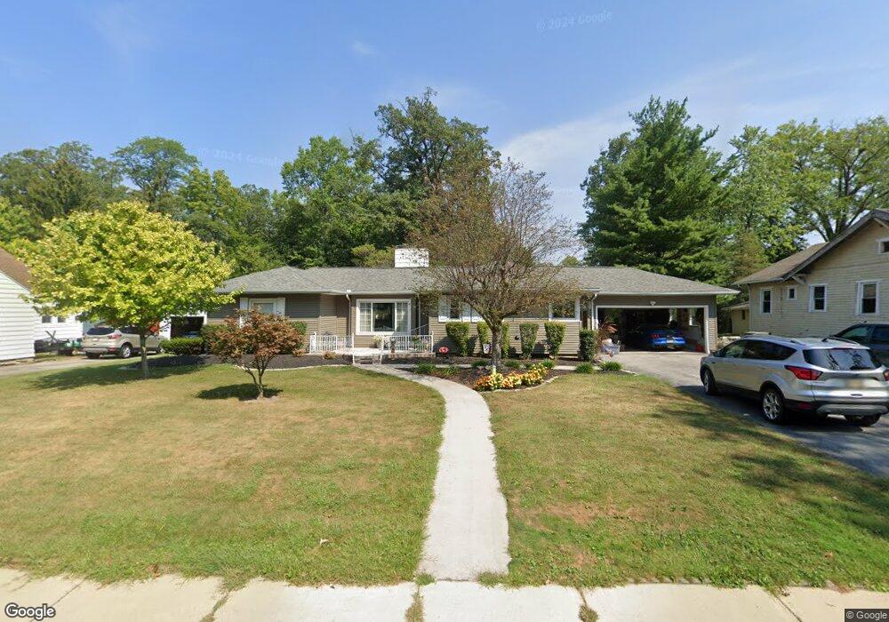
1708 W High St Lima, OH 45805
Westgate NeighborhoodEstimated Value: $235,000 - $275,000
3
Beds
3
Baths
2,256
Sq Ft
$110/Sq Ft
Est. Value
About This Home
This home is located at 1708 W High St, Lima, OH 45805 and is currently estimated at $248,765, approximately $110 per square foot. 1708 W High St is a home located in Allen County with nearby schools including Heritage Elementary School, Lima West Middle School, and Lima North Middle School.
Ownership History
Date
Name
Owned For
Owner Type
Purchase Details
Closed on
Nov 2, 2021
Sold by
Tegenkamp Diane M
Bought by
Tegenkamp Emily R and Tegenkamp Irrevocable Diane M
Current Estimated Value
Purchase Details
Closed on
Oct 20, 2021
Sold by
Tegenkamp Diane M and Diane M Tegenkamp Trust
Bought by
Tegenkamp Diane M
Purchase Details
Closed on
Sep 6, 2018
Sold by
Duffy Drew M and Rose Marie Duffy Living Trust
Bought by
Tegenkamp Diane M and Diane M Tegenkamp Trust
Purchase Details
Closed on
Jun 9, 1993
Sold by
Cauley John B
Bought by
Duffy Rose Marie
Purchase Details
Closed on
Jun 3, 1987
Bought by
Cauley John B
Create a Home Valuation Report for This Property
The Home Valuation Report is an in-depth analysis detailing your home's value as well as a comparison with similar homes in the area
Home Values in the Area
Average Home Value in this Area
Purchase History
| Date | Buyer | Sale Price | Title Company |
|---|---|---|---|
| Tegenkamp Emily R | -- | None Available | |
| Tegenkamp Diane M | -- | None Available | |
| Tegenkamp Diane M | -- | None Available | |
| Duffy Rose Marie | $73,000 | -- | |
| Cauley John B | $63,000 | -- |
Source: Public Records
Tax History Compared to Growth
Tax History
| Year | Tax Paid | Tax Assessment Tax Assessment Total Assessment is a certain percentage of the fair market value that is determined by local assessors to be the total taxable value of land and additions on the property. | Land | Improvement |
|---|---|---|---|---|
| 2024 | $2,658 | $79,000 | $12,250 | $66,750 |
| 2023 | $2,324 | $60,770 | $9,420 | $51,350 |
| 2022 | $2,292 | $59,580 | $9,420 | $50,160 |
| 2021 | $2,497 | $59,580 | $9,420 | $50,160 |
| 2020 | $2,315 | $49,360 | $9,000 | $40,360 |
| 2019 | $2,315 | $49,360 | $9,000 | $40,360 |
| 2018 | $1,832 | $49,360 | $9,000 | $40,360 |
| 2017 | $1,849 | $46,240 | $9,000 | $37,240 |
| 2016 | $1,868 | $46,240 | $9,000 | $37,240 |
| 2015 | $1,768 | $46,240 | $9,000 | $37,240 |
| 2014 | $1,768 | $43,650 | $8,890 | $34,760 |
| 2013 | $1,719 | $43,650 | $8,890 | $34,760 |
Source: Public Records
Map
Nearby Homes
- 1630 W Market St
- 109 N Pears Ave
- 1703 W Wayne St
- 1459 W Market St
- 1912 Hillcrest Dr
- 120 S Woodlawn Ave
- 1517 Allentown Rd
- 234 S Westwood Dr
- 2050 W Market St
- 209 N Dale Dr
- 2100 University Blvd
- 621 Fairfield Dr
- 1524 Wendell Ave
- 233 S Kenilworth Ave
- 1753 Leland Ave
- 2191 Lakewood Ave
- 514 N Cable Rd
- 1719 Latham Ave
- 1880 Wendell Ave
- 1206 Rice Ave