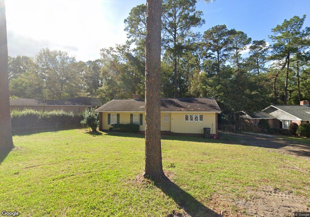
1709 Dean Dr Waycross, GA 31501
Estimated Value: $118,055 - $161,000
2
Beds
1
Bath
1,256
Sq Ft
$115/Sq Ft
Est. Value
About This Home
This home is located at 1709 Dean Dr, Waycross, GA 31501 and is currently estimated at $144,264, approximately $114 per square foot. 1709 Dean Dr is a home located in Ware County with nearby schools including Center Elementary School, Waycross Middle School, and Ware County High School.
Ownership History
Date
Name
Owned For
Owner Type
Purchase Details
Closed on
Sep 24, 2015
Sold by
Inman Linda Joyce Hayes
Bought by
Inman William Marvin and Williams Cheryl
Current Estimated Value
Purchase Details
Closed on
Aug 29, 2005
Sold by
Inman Linda J
Bought by
Inman Linda J and Inman William
Purchase Details
Closed on
Oct 20, 1992
Bought by
Inman Linda
Purchase Details
Closed on
Nov 8, 1989
Bought by
Ingalls Kimberly Lyn
Purchase Details
Closed on
Jun 28, 1989
Bought by
David Keith Ingalls
Purchase Details
Closed on
Sep 24, 1987
Create a Home Valuation Report for This Property
The Home Valuation Report is an in-depth analysis detailing your home's value as well as a comparison with similar homes in the area
Home Values in the Area
Average Home Value in this Area
Purchase History
| Date | Buyer | Sale Price | Title Company |
|---|---|---|---|
| Inman William Marvin | -- | -- | |
| Inman Linda J | -- | -- | |
| Inman Linda | $38,800 | -- | |
| Ingalls Kimberly Lyn | -- | -- | |
| David Keith Ingalls | $39,000 | -- | |
| -- | -- | -- |
Source: Public Records
Tax History Compared to Growth
Tax History
| Year | Tax Paid | Tax Assessment Tax Assessment Total Assessment is a certain percentage of the fair market value that is determined by local assessors to be the total taxable value of land and additions on the property. | Land | Improvement |
|---|---|---|---|---|
| 2024 | $1,297 | $32,778 | $2,691 | $30,087 |
| 2023 | $1,130 | $36,289 | $2,819 | $33,470 |
| 2022 | $1,446 | $36,289 | $2,819 | $33,470 |
| 2021 | $1,205 | $27,859 | $2,819 | $25,040 |
| 2020 | $1,181 | $27,101 | $2,819 | $24,282 |
| 2019 | $963 | $21,789 | $2,819 | $18,970 |
| 2018 | $939 | $21,030 | $2,819 | $18,211 |
| 2017 | $917 | $21,030 | $2,819 | $18,211 |
| 2016 | $917 | $21,030 | $2,819 | $18,211 |
| 2015 | $923 | $21,030 | $2,819 | $18,211 |
| 2014 | $922 | $21,030 | $2,819 | $18,211 |
| 2013 | -- | $21,030 | $2,819 | $18,211 |
Source: Public Records
Map
Nearby Homes
- 1011 Cherokee Cir
- 1103 Kontz Ave
- 1715 City Blvd
- 1002 Cherokee Cir
- Lot 3 City Blvd
- 2108 Screven Ave
- 1703 Rainbow Dr
- 00 Seminole Trail
- 1621 Camellia Dr
- 1206 Morningside Dr
- 1400 E Cherokee Dr
- 1001 Coral Rd
- 706 Cherokee Cir
- 1009 Euclid Ave
- 1500 Saint Marys Dr
- 907 Euclid Ave
- 1100 Euclid Ave
- 1701 Satilla Blvd
- 1002 Baltimore Ave
- 707 Euclid Ave
- 1707 Dean Dr
- 1711 Dean Dr
- 1006 Dogwood Dr
- 1015 Cherokee Cir
- 1712 Dean Dr
- 1009 Cherokee Cir
- 1102 Kontz Ave
- 1700 Dean Dr
- 1714 Dean Dr
- 1004 Dogwood Dr
- 1107 Cherokee Cir
- 1005 Cherokee Cir
- 1104 Kontz Ave
- 1718 Dean Dr
- 0 Cherokee Cir Unit 7184145
- 0 Cherokee Cir
- 1003 Dogwood Dr
- 1002 Dogwood Dr
- 1109 Cherokee Cir
- 1010 Cherokee Cir