$199,000
SOLD OCT 17, 2024
Last list price
4 Acres
$49,750 Price per Acre
174,240 Sq Ft Lot

Recently Sold

$134 Per Sq Ft

39 Days on Market

Highlights

  • 4 Acre Lot
  • No HOA
  • Rectangular Lot
  • Lewisburg Elementary School Rated A-
  • Shed
  • Partially Fenced Property

About This Lot

As of October 2024

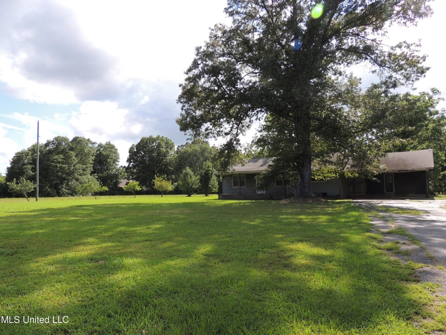
4 acres, more or less, located in the Lewisburg School District awaits new owner. This lovely, level acreage has good road frontage and could easily be divided into two or more lots. This is an as is sale as sellers will not remove old home or building or do any repairs, etc. This is a very convenient location about a mile North of the I-69 interchange. There are some mature trees on the property, as well as fruit trees. The driveway is asphalt.

Last Agent to Sell the Property

Rita Johnson

Crye-Leike Of MS-OB License #B-9920

Crye-Leike Of MS-OB

Last Buyer's Agent

Non MLS Member

Nonmls Office

Property Details

Property Type

  • Land

Est. Annual Taxes

  • $656

Year Built

  • 1956

Lot Details

  • 4 Acre Lot
  • Partially Fenced Property
  • Rectangular Lot
  • Cleared Lot
  • Few Trees
  • Zoning described as Agricultural District

Schools

  • Lewisburg Elementary School
  • Lewisburg Middle School
  • Lewisburg High School

Utilities

  • Propane
  • Septic Tank
  • Sewer Not Available
  • Phone Available
  • Cable TV Available

Listing and Financial Details

  • Assessor Parcel Number 2068280000000200

Community Details

Overview

  • No Home Owners Association
  • Metes And Bounds Subdivision

Recreation

  • Shed

Property Details

Property Type

Land

Est. Annual Taxes

$656

Year Built

1956

Lot Details

0

Listing Details

  • Property Sub Type: Acreage (10 acres or less)
  • Prop. Type: Land
  • Road Frontage Type: Highway
  • Road Surface Type: Asphalt
  • Lot Size Acres: 4.0
  • Subdivision Name: Metes And Bounds
  • Directions: On Highway 305 South of Olive Branch, about a mile North of the I-69 interchange on the West side of the highway.
  • New Construction: No
  • Special Features: None
  • Year Built: 1956

Interior Features

  • Possible Use: Agricultural, Development, Horses, Place of Worship, Residential, Single Family

Exterior Features

  • Disclosures: As Is
  • Fencing: Partial
  • Lot Features: Cleared, Few Trees, Level, Rectangular Lot
  • Other Structures: Shed(s)
  • WaterfrontFeaturesWaterfront: No
  • Lot Features:Few Trees: Yes
  • Lot Features:Cleared: Yes
  • Lot Features:Rectangular Lot: Yes
  • Lot Features:Level: Yes

Utilities

  • Sewer: Septic Tank
  • Utilities: Cable Available, Electricity Available, Phone Available, Propane Available, Sewer Not Available, Water Available
  • Water Source: Public
  • Sewer Septic Tank: Yes

Association/Amenities

  • HorseAmenitiesHorseAmenities: No
  • Tax and Financial Information:Association: No

Schools

  • Elementary School: Lewisburg
  • High School: Lewisburg
  • Middle Or Junior School: Lewisburg Middle

Lot Info

  • Current Use: None
  • Parcel #: 2068280000000200
  • Lot Size Sq Ft: 174240.0
  • Zoning Description: Agricultural District
  • ResoLotSizeUnits: Acres

Tax Info

  • Tax Annual Amount: 656.0
  • Tax Year: 2023

Ownership History

Date Name Owned For Owner Type

Purchase Details

Closed on
Oct 24, 2020
Sold by
Decker Alice
Bought by
Wilder Robert G
Total Days on Market
39
Current Estimated Value
$189,863

Map

Range of Values:

Collateral Analytics

Collateral Analytics Collateral Analytics AVMs (Automated Valuation Model) employ a number of statistical approaches combined with neighborhood-specific comparable selection guarantees the most up-to-date and precise valuations.

Not Available

Collateral Analytics does not have data for the current month. Please view the chart for historical values.

ICE

ICE Mortgage Technology ICE Mortgage Technology’s AVM (Automated Valuation Model) is a state-of-the-art online residential property valuation tool that provides a quick and accurate estimate of the value of almost any home in the U.S.

Not Available

ICE Mortgage Technology does not have data for the current month. Please view the chart for historical values.

First American

First American First American Data & Analytics’ next-generation AVM combines unrivaled data assets with a blended ensemble of valuation models to produce highly accurate, reliable valuations you can trust.

Not Available

First American does not have data for the current month. Please view the chart for historical values.

Quantarium

Quantarium Quantarium’s valuation service, repeatedly proven the industry’s most accurate and comprehensive, is supercharged with a self-learning and auto-tuning AI engine that continually becomes smarter and more accurate as it processes daily inputs from the industry’s leading RE data lake.

Not Available

Quantarium does not have data for the current month. Please view the chart for historical values.

Average Value
Not Available
List Price
Sold Price
Create a Home Valuation Report for This Property
The Home Valuation Report is an in-depth analysis detailing your home's value as well as a comparison with similar homes in the area

Similar Property in Olive Branch, MS

  • 9404 Byhalia Rd, Olive Branch, MS 38654

    $155,000

    • Land
    • 4.42 Acres
    • $35,068 per Acre
    • 9404 Byhalia Rd
    • Olive Branch, MS

    This is the perfect lot to build on if you are looking for land in Lewisburg. Right off 69, so convenient to everywhere! Drive past anytime!

    Lynley Churchwell Re/Max Experts

    Section Image

Home Values in the Area

Source: Public Records

Average Home Value in this Area


Source: Public Records

Purchase History

Date Type Sale Price Title Company
Quit Claim Deed -- None Available
Source: Public Records

Mortgage History

Date Status Loan Amount Loan Type
Open $100,000 Credit Line Revolving
Source: Public Records

Property History

Date Event Price Change Sq Ft Price
10/17/2024 10/17/24 Sold -- -- --
07/16/2024 07/16/24 Pending -- -- --
07/08/2024 07/08/24 Price Changed $199,000 -20.4% $134 / Sq Ft
06/06/2024 06/06/24 For Sale $250,000 -- $168 / Sq Ft
Source: MLS United

Tax History

Year Tax Paid Tax Assessment Tax Assessment Total Assessment is a certain percentage of the fair market value that is determined by local assessors to be the total taxable value of land and additions on the property. Land Improvement
2024 $656 $6,495 $3,600 $2,895
2023 $656 $6,495 $0 $0
2022 $656 $6,495 $3,600 $2,895
2021 $656 $6,495 $3,600 $2,895
2020 $632 $6,263 $3,600 $2,663
2019 $632 $6,263 $3,600 $2,663
2017 $636 $8,906 $6,253 $2,653
2016 $632 $6,213 $3,600 $2,613
2015 $632 $8,826 $6,213 $2,613
2014 $632 $6,213 $0 $0
2013 $559 $6,213 $0 $0
Source: Public Records

Source: MLS United

MLS Number: 4081821

MLS United

APN: 2068280000000200