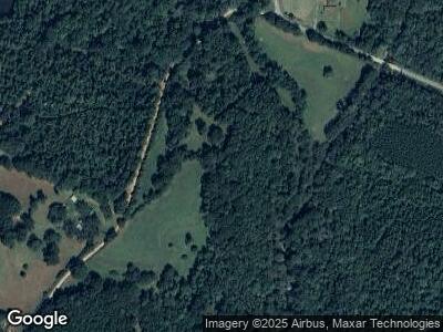
171 Allen Rd the Rock, GA 30285
Estimated Value: $212,000 - $387,745
4
Beds
2
Baths
2,224
Sq Ft
$147/Sq Ft
Est. Value
About This Home
This home is located at 171 Allen Rd, the Rock, GA 30285 and is currently estimated at $325,936, approximately $146 per square foot. 171 Allen Rd is a home located in Lamar County with nearby schools including Lamar County Primary School, Lamar County Elementary School, and Lamar County Middle School.
Ownership History
Date
Name
Owned For
Owner Type
Purchase Details
Closed on
Mar 22, 2013
Sold by
Allen Curtis Buel
Bought by
Allen Curtis Buel
Current Estimated Value
Purchase Details
Closed on
Sep 2, 2011
Sold by
Hooper Mary Ann
Bought by
Allen Curtis Buel
Purchase Details
Closed on
Dec 29, 2010
Sold by
Allen Curtis Buel
Bought by
Hooper Mary Ann Allen
Purchase Details
Closed on
May 1, 1989
Sold by
Allen Cw Est
Bought by
Allen Curtis and Allen Cla
Create a Home Valuation Report for This Property
The Home Valuation Report is an in-depth analysis detailing your home's value as well as a comparison with similar homes in the area
Home Values in the Area
Average Home Value in this Area
Purchase History
| Date | Buyer | Sale Price | Title Company |
|---|---|---|---|
| Allen Curtis Buel | -- | -- | |
| Allen Curtis Buel | -- | -- | |
| Hooper Mary Ann Allen | -- | -- | |
| Allen Curtis | -- | -- |
Source: Public Records
Tax History Compared to Growth
Tax History
| Year | Tax Paid | Tax Assessment Tax Assessment Total Assessment is a certain percentage of the fair market value that is determined by local assessors to be the total taxable value of land and additions on the property. | Land | Improvement |
|---|---|---|---|---|
| 2024 | $1,470 | $120,387 | $75,986 | $44,401 |
| 2023 | $1,632 | $122,452 | $75,986 | $46,466 |
| 2022 | $1,628 | $95,179 | $50,499 | $44,680 |
| 2021 | $765 | $62,019 | $50,499 | $11,520 |
| 2020 | $795 | $64,717 | $53,197 | $11,520 |
| 2019 | $786 | $64,717 | $53,197 | $11,520 |
| 2018 | $745 | $64,717 | $53,197 | $11,520 |
| 2017 | $731 | $64,717 | $53,197 | $11,520 |
| 2016 | $722 | $64,717 | $53,197 | $11,520 |
| 2015 | $712 | $64,717 | $53,197 | $11,520 |
| 2014 | $681 | $64,717 | $53,197 | $11,520 |
| 2013 | -- | $64,717 | $53,197 | $11,520 |
Source: Public Records
Map
Nearby Homes
- 0 Leach Rd Unit 10470602
- 0 Bankston Rd
- 1940 Vega Rd
- 587 Piedmont Rd
- 0 Alabama Rd Unit 22813063
- 34.61 ACRES Walker Rd
- 967 Vega Rd
- 514 Adams Rd
- 0 Potato Creek Rd Unit 10350303
- 430 Rose Creek Rd
- 0 Perkins Rd Unit 10523165
- 0 Billies Way Unit 10435066
- 0 Stewart Rd
- LOT 9 Stewart Rd
- 282 Perkins Rd
- LOT 10 Flint Farms Dr
- 1325 Adams Rd
- 297 Bishop Rd
- 275 Bishop Rd
- 561 Jugtown Rd
- 171 Allen Rd
- 229 Allen Rd
- 1200 Piedmont Rd
- 1081 Piedmont Rd
- 1081 Piedmont Rd Unit 109
- 1075 Piedmont Rd
- 1860 Vega Rd Unit A3 & A4
- 2475 Vega Rd Unit 5&6
- 1144 Piedmont Rd
- 1099 Piedmont Rd
- 0 Allen Rd Unit 8287180
- 0 Allen Rd
- 1100 Piedmont Rd
- 0 Vega Rd Unit 8454212
- 0 Vega Rd
- 0 Vega Rd Unit 5&6 7442492
- 0 Vega Rd Unit 8011922
- 0 Vega Rd Unit 8949743
- 0 Vega Rd Unit 9050690
- 0 Vega Rd Unit 8182389
