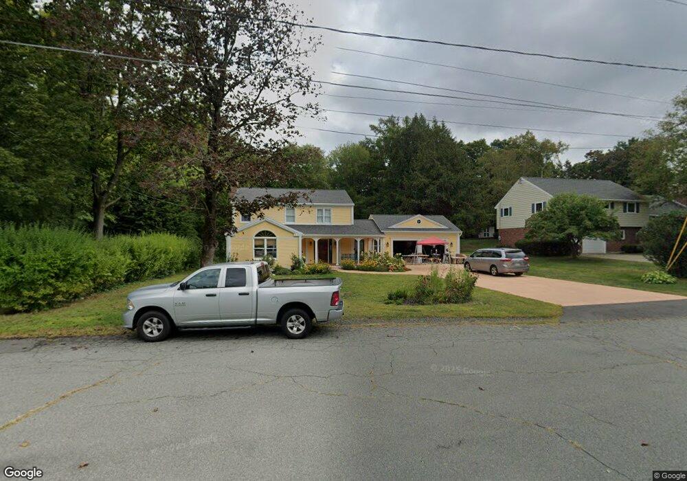
171 Gray St Amherst, MA 01002
Estimated Value: $543,000 - $594,000
3
Beds
2
Baths
2,192
Sq Ft
$257/Sq Ft
Est. Value
About This Home
This home is located at 171 Gray St, Amherst, MA 01002 and is currently estimated at $562,458, approximately $256 per square foot. 171 Gray St is a home located in Hampshire County with nearby schools including Wildwood Elementary School, Amherst Regional Middle School, and Amherst Regional High School.
Ownership History
Date
Name
Owned For
Owner Type
Purchase Details
Closed on
Sep 24, 2021
Sold by
Daisy Mae Realty Llc
Bought by
Nielsen Scott J
Current Estimated Value
Purchase Details
Closed on
May 27, 2020
Sold by
Daisy Mae Realty Llc
Bought by
Levine Elinor
Purchase Details
Closed on
Jan 28, 2020
Sold by
Boudreau Paul and Aubrey Gerard N
Bought by
Daisy Mae Realty Llc
Purchase Details
Closed on
Sep 20, 2016
Sold by
Weiner Gary M and Nielsen Scott J
Bought by
Aubrey Gerard N and Boudreau Paul
Purchase Details
Closed on
Mar 29, 2011
Sold by
Nielsen Scott J and Levine Elinor R
Bought by
Amherst Town Of
Purchase Details
Closed on
Aug 23, 1985
Bought by
Nielsen Scott J and Levine Elinor R
Create a Home Valuation Report for This Property
The Home Valuation Report is an in-depth analysis detailing your home's value as well as a comparison with similar homes in the area
Home Values in the Area
Average Home Value in this Area
Purchase History
| Date | Buyer | Sale Price | Title Company |
|---|---|---|---|
| Nielsen Scott J | -- | None Available | |
| Levine Elinor | -- | None Available | |
| Daisy Mae Realty Llc | $300,000 | None Available | |
| Aubrey Gerard N | $250,000 | -- | |
| Amherst Town Of | $7,095 | -- | |
| Nielsen Scott J | $154,000 | -- |
Source: Public Records
Mortgage History
| Date | Status | Borrower | Loan Amount |
|---|---|---|---|
| Previous Owner | Nielsen Scott J | $50,000 | |
| Previous Owner | Nielsen Scott J | $158,400 |
Source: Public Records
Tax History
| Year | Tax Paid | Tax Assessment Tax Assessment Total Assessment is a certain percentage of the fair market value that is determined by local assessors to be the total taxable value of land and additions on the property. | Land | Improvement |
|---|---|---|---|---|
| 2025 | $85 | $473,300 | $203,100 | $270,200 |
| 2024 | $8,289 | $447,800 | $191,600 | $256,200 |
| 2023 | $8,038 | $399,900 | $174,200 | $225,700 |
| 2022 | $7,217 | $339,300 | $158,400 | $180,900 |
| 2021 | $8,095 | $371,000 | $146,800 | $224,200 |
| 2020 | $7,910 | $371,000 | $146,800 | $224,200 |
| 2019 | $7,656 | $351,200 | $146,800 | $204,400 |
| 2018 | $7,424 | $351,200 | $146,800 | $204,400 |
| 2017 | $7,525 | $344,700 | $139,800 | $204,900 |
| 2016 | $7,315 | $344,700 | $139,800 | $204,900 |
| 2015 | $7,080 | $344,700 | $139,800 | $204,900 |
Source: Public Records
Map
Nearby Homes
- 0 Red Gate Ln Unit 73348273
- 50 Mount Pleasant
- 242 N East St Unit 24
- 0 Main St
- 32 N Prospect St Unit 5
- 174 Lincoln Ave
- 75 Amity Place Unit 75
- 60 Amity Place
- 185 Cherry Ln
- 310 Belchertown Rd
- 0 Heatherstone Rd
- 0 Amherst Rd
- 12 Kettle Pond Rd
- 10 Eaton Ct
- 208 Rolling Ridge Rd
- 167 Rolling Ridge Rd
- Lot A Kingman Rd
- 9 Harkness Rd
- 24 Greenleaves Dr Unit 418
- 228 Aubinwood Rd
Your Personal Tour Guide
Ask me questions while you tour the home.