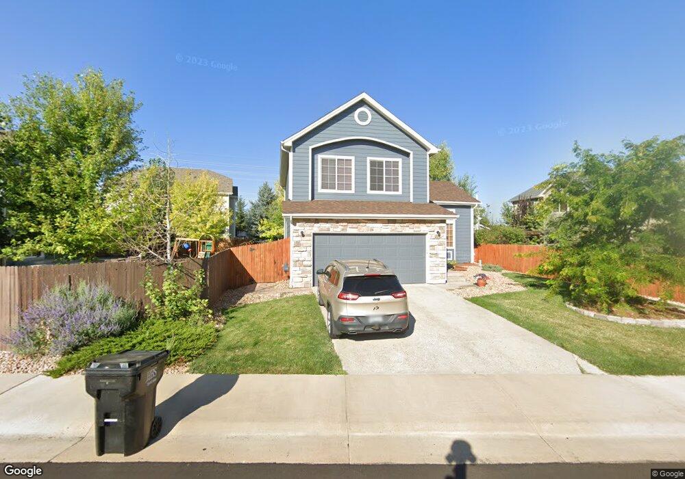
171 High Plains St Castle Rock, CO 80104
Founders Village NeighborhoodEstimated Value: $529,152 - $555,000
3
Beds
3
Baths
1,578
Sq Ft
$343/Sq Ft
Est. Value
About This Home
This home is located at 171 High Plains St, Castle Rock, CO 80104 and is currently estimated at $541,788, approximately $343 per square foot. 171 High Plains St is a home located in Douglas County with nearby schools including Flagstone Elementary School, Mesa Middle School, and Douglas County High School.
Ownership History
Date
Name
Owned For
Owner Type
Purchase Details
Closed on
Jul 22, 2022
Sold by
Conover James S
Bought by
Balbin Austin and Balbin Christina
Current Estimated Value
Home Financials for this Owner
Home Financials are based on the most recent Mortgage that was taken out on this home.
Original Mortgage
$445,000
Outstanding Balance
$376,234
Interest Rate
4.92%
Mortgage Type
New Conventional
Estimated Equity
$165,554
Purchase Details
Closed on
Jun 16, 2010
Sold by
Chinnick James S and Chinnick Kelly M
Bought by
Conover James S and Conover Kelly
Purchase Details
Closed on
Mar 19, 2004
Sold by
Engle Homes Colorado
Bought by
Chinnick James S and Chinnick Kelly M
Home Financials for this Owner
Home Financials are based on the most recent Mortgage that was taken out on this home.
Original Mortgage
$237,250
Interest Rate
5.59%
Mortgage Type
Unknown
Create a Home Valuation Report for This Property
The Home Valuation Report is an in-depth analysis detailing your home's value as well as a comparison with similar homes in the area
Home Values in the Area
Average Home Value in this Area
Purchase History
| Date | Buyer | Sale Price | Title Company |
|---|---|---|---|
| Balbin Austin | $565,000 | First American Title | |
| Conover James S | -- | None Available | |
| Chinnick James S | $237,300 | -- |
Source: Public Records
Mortgage History
| Date | Status | Borrower | Loan Amount |
|---|---|---|---|
| Open | Balbin Austin | $445,000 | |
| Previous Owner | Chinnick James S | $237,250 |
Source: Public Records
Tax History Compared to Growth
Tax History
| Year | Tax Paid | Tax Assessment Tax Assessment Total Assessment is a certain percentage of the fair market value that is determined by local assessors to be the total taxable value of land and additions on the property. | Land | Improvement |
|---|---|---|---|---|
| 2024 | $5,439 | $36,790 | $8,360 | $28,430 |
| 2023 | $5,471 | $36,790 | $8,360 | $28,430 |
| 2022 | $3,933 | $24,840 | $6,140 | $18,700 |
| 2021 | $4,007 | $24,840 | $6,140 | $18,700 |
| 2020 | $3,824 | $24,410 | $5,120 | $19,290 |
| 2019 | $3,826 | $24,410 | $5,120 | $19,290 |
| 2018 | $3,426 | $21,690 | $4,160 | $17,530 |
| 2017 | $3,298 | $21,690 | $4,160 | $17,530 |
| 2016 | $2,663 | $18,290 | $4,000 | $14,290 |
| 2015 | $2,697 | $18,290 | $4,000 | $14,290 |
| 2014 | $2,298 | $14,960 | $3,420 | $11,540 |
Source: Public Records
Map
Nearby Homes
- 5282 Devon Ave
- 5323 E Sandpiper Ave
- 176 S Pembrook St
- 5181 Devon Ave
- 157 S Quicksilver Ave
- 5326 E Howe St
- 109 N Quicksilver Ave
- 510 Fairhaven St
- 364 N Willow St
- 596 S Lindsey St
- 630 Fairhaven St
- 5521 Spruce Ave
- 330 N Wagonwheel Trail
- 5864 Turnstone Place
- 535 Howe St
- 321 Lockwood St
- 5931 Wescroft Ave
- 5617 E Prescott Ave
- 5230 E Kensington Ave
- 650 Howe Cir
- 5355 High Plains Place
- 5304 Lost Meadow Trail
- 5327 High Plains Place
- 5330 Lost Meadow Trail
- 5280 Lost Meadow Trail
- 5311 High Plains Place
- 178 High Plains St
- 162 High Plains St
- 200 High Plains St
- 144 High Plains St
- 216 High Plains St
- 232 High Plains St
- 5303 Lost Meadow Trail
- 5354 High Plains Place
- 161 S Cherry St
- 179 S Cherry St
- 5325 Lost Meadow Trail
- 5339 Lost Meadow Trail
- 5365 Lost Meadow Trail
- 193 S Cherry St