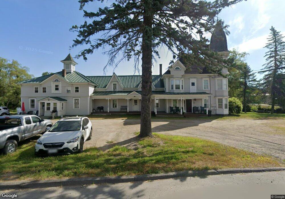
171 Main St Eustis, ME 04936
Estimated Value: $242,000 - $628,000
--
Bed
7
Baths
5,527
Sq Ft
$77/Sq Ft
Est. Value
About This Home
This home is located at 171 Main St, Eustis, ME 04936 and is currently estimated at $427,392, approximately $77 per square foot. 171 Main St is a home located in Franklin County with nearby schools including Stratton Elementary School.
Ownership History
Date
Name
Owned For
Owner Type
Purchase Details
Closed on
Apr 10, 2023
Sold by
Lannon Jennifer and Bigelow Brian
Bought by
Bigelows Alpine Lodge Llc
Current Estimated Value
Home Financials for this Owner
Home Financials are based on the most recent Mortgage that was taken out on this home.
Original Mortgage
$228,000
Outstanding Balance
$220,328
Interest Rate
6.5%
Mortgage Type
Purchase Money Mortgage
Estimated Equity
$207,064
Purchase Details
Closed on
Mar 23, 2018
Sold by
Citibank Na Tr
Bought by
Lannon Jennifer and Bigelow Brian
Home Financials for this Owner
Home Financials are based on the most recent Mortgage that was taken out on this home.
Original Mortgage
$79,000
Interest Rate
4.75%
Mortgage Type
Adjustable Rate Mortgage/ARM
Purchase Details
Closed on
Nov 6, 2017
Sold by
Kot Cristina M and Kot Steven S
Bought by
Citibank Na Tr
Purchase Details
Closed on
Dec 4, 2006
Sold by
Hopson Jerome V and Hopson Mary P
Bought by
Kot Cristina M and Kot Steven
Home Financials for this Owner
Home Financials are based on the most recent Mortgage that was taken out on this home.
Original Mortgage
$125,000
Interest Rate
6.36%
Mortgage Type
Purchase Money Mortgage
Create a Home Valuation Report for This Property
The Home Valuation Report is an in-depth analysis detailing your home's value as well as a comparison with similar homes in the area
Purchase History
| Date | Buyer | Sale Price | Title Company |
|---|---|---|---|
| Bigelows Alpine Lodge Llc | -- | None Available | |
| Lannon Jennifer | -- | -- | |
| Citibank Na Tr | -- | -- | |
| Kot Cristina M | -- | -- | |
| Kot Cristina M | -- | -- |
Source: Public Records
Mortgage History
| Date | Status | Borrower | Loan Amount |
|---|---|---|---|
| Open | Bigelows Alpine Lodge Llc | $228,000 | |
| Previous Owner | Lannon Jennifer | $79,000 | |
| Previous Owner | Kot Cristina M | $169,600 | |
| Previous Owner | Kot Cristina M | $125,000 |
Source: Public Records
Tax History
| Year | Tax Paid | Tax Assessment Tax Assessment Total Assessment is a certain percentage of the fair market value that is determined by local assessors to be the total taxable value of land and additions on the property. | Land | Improvement |
|---|---|---|---|---|
| 2024 | $3,203 | $366,000 | $36,500 | $329,500 |
| 2023 | $3,290 | $367,600 | $36,500 | $331,100 |
| 2022 | $4,168 | $438,700 | $36,500 | $402,200 |
| 2021 | $2,856 | $221,400 | $28,800 | $192,600 |
| 2020 | $2,768 | $221,400 | $28,800 | $192,600 |
| 2019 | $2,443 | $201,900 | $28,800 | $173,100 |
| 2018 | $2,645 | $201,900 | $28,800 | $173,100 |
| 2017 | $2,625 | $201,900 | $28,800 | $173,100 |
| 2016 | $2,578 | $201,900 | $28,800 | $173,100 |
| 2015 | $2,665 | $201,900 | $28,800 | $173,100 |
| 2014 | $2,226 | $202,400 | $28,800 | $173,600 |
| 2009 | -- | $206,600 | $30,500 | $176,100 |
Source: Public Records
Map
Nearby Homes
- 186 Main St
- 128 Main St
- 9 Tranquility Ln
- 14 Dam Rd
- 12 Bog Rd
- 27 Peabody Rd
- 27 Reed Rd
- 600 Arnold Trail
- 6-01 Eustis Ridge Rd
- 60&66 Gravel Pit Rd
- 484 Eustis Ridge Rd
- 64 Ip Rd
- 233 Porter Nadeau Rd
- 95-4 Lot D Porter Nadeau Rd
- 54 Eustis Village Rd
- 59 Eustis Village Rd
- 33A Eustis Village Rd
- 118 Glidden Rd
- 1480 Arnold Trail
- 42 Rabbit Hollow Rd