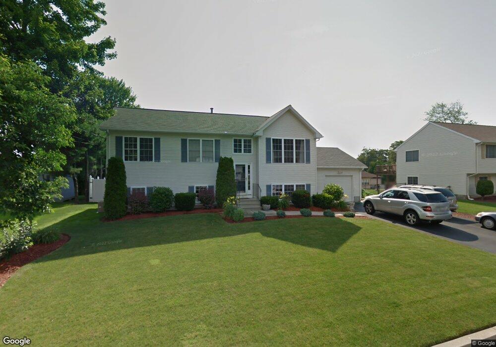
171 Mohawk Trail Cranston, RI 02921
Western Cranston NeighborhoodEstimated Value: $544,155 - $610,000
3
Beds
2
Baths
1,500
Sq Ft
$389/Sq Ft
Est. Value
About This Home
This home is located at 171 Mohawk Trail, Cranston, RI 02921 and is currently estimated at $583,789, approximately $389 per square foot. 171 Mohawk Trail is a home located in Providence County with nearby schools including Orchard Farms El. School, Hope Highlands Middle School, and Cranston High School West.
Ownership History
Date
Name
Owned For
Owner Type
Purchase Details
Closed on
Jun 14, 2002
Sold by
Doughty Patricia and Doughty Henry
Bought by
Bernardo John L
Current Estimated Value
Purchase Details
Closed on
May 28, 1999
Sold by
Mitola Vincent G
Bought by
Doughty Patricia A and Godin Henry H
Create a Home Valuation Report for This Property
The Home Valuation Report is an in-depth analysis detailing your home's value as well as a comparison with similar homes in the area
Home Values in the Area
Average Home Value in this Area
Purchase History
| Date | Buyer | Sale Price | Title Company |
|---|---|---|---|
| Bernardo John L | $220,000 | -- | |
| Doughty Patricia A | $143,000 | -- |
Source: Public Records
Mortgage History
| Date | Status | Borrower | Loan Amount |
|---|---|---|---|
| Open | Doughty Patricia A | $25,000 | |
| Open | Doughty Patricia A | $182,000 | |
| Closed | Doughty Patricia A | $212,000 |
Source: Public Records
Tax History
| Year | Tax Paid | Tax Assessment Tax Assessment Total Assessment is a certain percentage of the fair market value that is determined by local assessors to be the total taxable value of land and additions on the property. | Land | Improvement |
|---|---|---|---|---|
| 2025 | $6,374 | $459,200 | $138,400 | $320,800 |
| 2024 | $6,250 | $459,200 | $138,400 | $320,800 |
| 2023 | $6,228 | $329,500 | $99,000 | $230,500 |
| 2022 | $6,099 | $329,500 | $99,000 | $230,500 |
| 2021 | $5,931 | $329,500 | $99,000 | $230,500 |
| 2020 | $6,088 | $293,100 | $99,000 | $194,100 |
| 2019 | $6,088 | $293,100 | $99,000 | $194,100 |
| 2018 | $5,947 | $293,100 | $99,000 | $194,100 |
| 2017 | $5,955 | $259,600 | $84,900 | $174,700 |
| 2016 | $5,828 | $259,600 | $84,900 | $174,700 |
| 2015 | $5,828 | $259,600 | $84,900 | $174,700 |
| 2014 | $4,634 | $202,900 | $70,700 | $132,200 |
Source: Public Records
Map
Nearby Homes
- 102 Moccasin Trail
- 0 Anthony Dr Unit 1394338
- 121 Ashbrook Dr
- 1495 Pippin Orchard Rd
- 141 Fox Ridge Dr
- 311 Hope Rd
- 02 Paula Ln
- 01 Paula Ln
- 12 Beechwood Dr
- 154 Beechwood Dr
- 244 Beechwood Dr
- 20 Doreen Ct
- 65 Janet Dr
- 1213 Phenix Ave
- 105 Amy Dr
- 95 Amy Dr
- 25 Janet Dr
- 22 Derby Ln
- 64 Cardinal Rd
- 74 Cardinal Rd
- 175 Mohawk Trail
- 165 Mohawk Trail
- 140 Canonchet Trail
- 130 Canonchet Trail
- 172 Mohawk Trail
- 159 Mohawk Trail
- 177 Mohawk Trail
- 180 Mohawk Trail
- 164 Mohawk Trail
- 160 Mohawk Trail
- 129 Canonchet Trail
- 154 Canonchet Trail
- 137 Canonchet Trail
- 118 Canonchet Trail
- 10 Agawam Trail
- 150 Canonchet
- 192 Mohawk Trail
- 154 Mohawk Trail
- 147 Mohawk Trail
- 197 Mohawk Trail
Your Personal Tour Guide
Ask me questions while you tour the home.