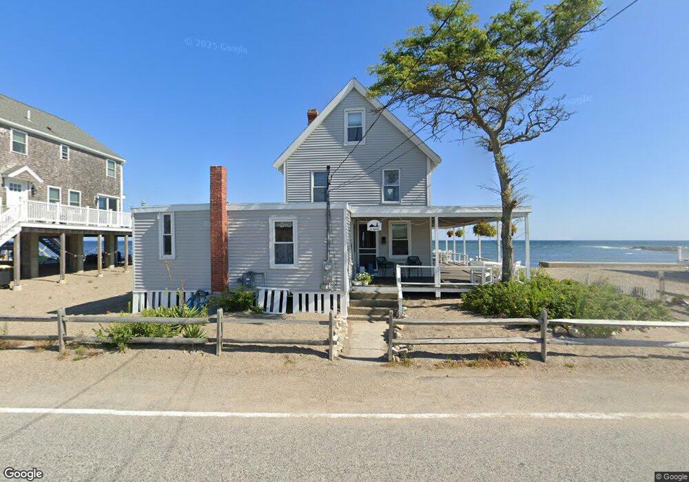
171 Turner Rd Scituate, MA 02066
Estimated Value: $950,000 - $1,087,000
4
Beds
2
Baths
1,740
Sq Ft
$579/Sq Ft
Est. Value
About This Home
This home is located at 171 Turner Rd, Scituate, MA 02066 and is currently estimated at $1,008,257, approximately $579 per square foot. 171 Turner Rd is a home located in Plymouth County with nearby schools including Jenkins Elementary School, Lester J. Gates Middle School, and Scituate High School.
Ownership History
Date
Name
Owned For
Owner Type
Purchase Details
Closed on
Apr 2, 2024
Sold by
Hendrickson Shirley H Est and Hendrickson
Bought by
Shirley R Hendrickson Ret and Hendrick
Current Estimated Value
Purchase Details
Closed on
Dec 4, 2013
Sold by
Flanagan Georgia H Est and Spielvogel
Bought by
Flanagan Georgia V and Flanagan John C
Purchase Details
Closed on
Nov 29, 2012
Sold by
Hallam Phyllis M
Bought by
Hallam Philip G and White Linda H
Purchase Details
Closed on
Jan 1, 1970
Bought by
Hession Georgia and Hendrickson Shirley R
Create a Home Valuation Report for This Property
The Home Valuation Report is an in-depth analysis detailing your home's value as well as a comparison with similar homes in the area
Home Values in the Area
Average Home Value in this Area
Purchase History
| Date | Buyer | Sale Price | Title Company |
|---|---|---|---|
| Shirley R Hendrickson Ret | -- | None Available | |
| Shirley R Hendrickson Ret | -- | None Available | |
| Flanagan Georgia V | -- | -- | |
| Flanagan Georgia V | -- | -- | |
| Hallam Philip G | -- | -- | |
| Hallam Philip G | -- | -- | |
| Hession Georgia | -- | -- |
Source: Public Records
Tax History Compared to Growth
Tax History
| Year | Tax Paid | Tax Assessment Tax Assessment Total Assessment is a certain percentage of the fair market value that is determined by local assessors to be the total taxable value of land and additions on the property. | Land | Improvement |
|---|---|---|---|---|
| 2025 | $9,274 | $928,300 | $697,400 | $230,900 |
| 2024 | $8,184 | $790,000 | $563,600 | $226,400 |
| 2023 | $6,011 | $609,500 | $512,400 | $97,100 |
| 2022 | $6,011 | $476,300 | $394,900 | $81,400 |
| 2021 | $6,009 | $450,800 | $376,100 | $74,700 |
| 2020 | $5,920 | $438,500 | $361,600 | $76,900 |
| 2019 | $6,267 | $456,100 | $378,200 | $77,900 |
| 2018 | $6,570 | $471,000 | $382,800 | $88,200 |
| 2017 | $6,494 | $460,900 | $372,700 | $88,200 |
| 2016 | $6,330 | $447,700 | $362,600 | $85,100 |
| 2015 | $5,997 | $457,800 | $372,700 | $85,100 |
Source: Public Records
Map
Nearby Homes
- 105 Turner Rd
- 23 Oceanside Dr
- 32 Barker Rd Unit 3
- 23 Sunset Rd
- 10 Benjamin Ln Unit 10
- 209 Hatherly Rd
- 91 Front St Unit 106
- 74 Tilden Rd
- 30 Irving Rd
- 76 A Brook St
- 76 A Brook St Unit 1
- 17 Bradford Ave
- 50 First Parish Rd
- 22 Kings Way
- 378 Tilden Rd
- 2 Windward Ln
- 54 Woodland Rd
- 111 Elm St
- 59 Greenfield Ln
- 115 Elm St
- 167 Turner Rd
- 173 Turner Rd
- 170 Turner Rd
- 165 Turner Rd
- 168 Turner Rd
- 175 Turner Rd
- 163 Turner Rd
- 161 Turner Rd
- 161 Turner Rd
- 179 Turner Rd
- 159 Turner Rd
- 169 Jericho Rd
- 164 Turner Rd
- 164 Turner Rd Unit 1
- 164A Turner Rd
- 157 Turner Rd
- 167 Jericho Rd
- 160 Turner Rd
- 160 Turner Rd Unit 2
- 160 Turner Rd Unit 6