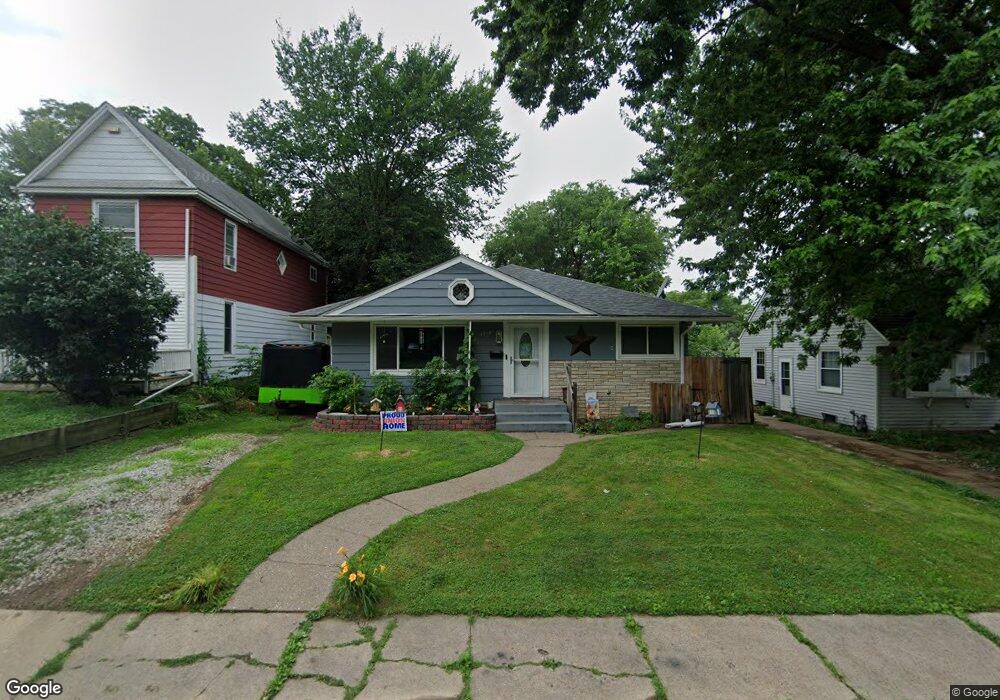
1710 Esplanade Ave Davenport, IA 52803
East End NeighborhoodEstimated Value: $132,000 - $212,000
3
Beds
3
Baths
1,230
Sq Ft
$137/Sq Ft
Est. Value
About This Home
This home is located at 1710 Esplanade Ave, Davenport, IA 52803 and is currently estimated at $167,950, approximately $136 per square foot. 1710 Esplanade Ave is a home located in Scott County with nearby schools including Caverna Elementary School, Casey County Middle School, and Hopkinsville Middle School.
Ownership History
Date
Name
Owned For
Owner Type
Purchase Details
Closed on
Dec 19, 2011
Sold by
Bloomington Holdings Llc
Bought by
B & V Partners Llc 4
Current Estimated Value
Purchase Details
Closed on
May 5, 2005
Sold by
Mays Willis L and Mays Vikki L
Bought by
Contract Funding Llc
Home Financials for this Owner
Home Financials are based on the most recent Mortgage that was taken out on this home.
Original Mortgage
$66,000
Interest Rate
6.05%
Mortgage Type
Purchase Money Mortgage
Create a Home Valuation Report for This Property
The Home Valuation Report is an in-depth analysis detailing your home's value as well as a comparison with similar homes in the area
Home Values in the Area
Average Home Value in this Area
Purchase History
| Date | Buyer | Sale Price | Title Company |
|---|---|---|---|
| B & V Partners Llc 4 | -- | None Available | |
| Contract Funding Llc | $66,000 | None Available |
Source: Public Records
Mortgage History
| Date | Status | Borrower | Loan Amount |
|---|---|---|---|
| Previous Owner | Contract Funding Llc | $66,000 |
Source: Public Records
Tax History Compared to Growth
Tax History
| Year | Tax Paid | Tax Assessment Tax Assessment Total Assessment is a certain percentage of the fair market value that is determined by local assessors to be the total taxable value of land and additions on the property. | Land | Improvement |
|---|---|---|---|---|
| 2025 | $2,432 | $171,730 | $17,500 | $154,230 |
| 2024 | $1,974 | $136,130 | $17,500 | $118,630 |
| 2023 | $2,452 | $113,130 | $17,500 | $95,630 |
| 2022 | $2,464 | $114,800 | $10,500 | $104,300 |
| 2021 | $2,464 | $114,800 | $10,500 | $104,300 |
| 2020 | $1,428 | $98,600 | $10,500 | $88,100 |
| 2019 | $1,422 | $63,360 | $10,500 | $52,860 |
| 2018 | $1,392 | $63,360 | $10,500 | $52,860 |
| 2017 | $352 | $63,360 | $10,500 | $52,860 |
| 2016 | $1,388 | $63,360 | $0 | $0 |
| 2015 | $1,388 | $57,390 | $0 | $0 |
| 2014 | $1,274 | $80,390 | $0 | $0 |
| 2013 | $1,754 | $0 | $0 | $0 |
| 2012 | -- | $49,960 | $12,180 | $37,780 |
Source: Public Records
Map
Nearby Homes
- 1626 Esplanade Ave
- 1616 Esplanade Ave
- 1310 Kirkwood Blvd
- 1501 Bridge Ave
- 2030 Esplanade Ave
- 1325 Mississippi Ave
- 1920 Carey Ave
- 1020 E 15th St
- 1220 College Ave
- 2116 Eastern Ave
- 916 Kirkwood Blvd
- 1202 Adams St
- 1605 Arlington Ave
- 1603 Arlington Ave
- 1233 Eastern Ave
- 2125 Eastern Ave
- 1102 College Ave
- 11 Oak Ln
- 1224 E 11th St
- 1012 Bridge Ave
- 1706 Esplanade Ave
- 1714 Esplanade Ave
- 1720 Esplanade Ave
- 1622 Esplanade Ave
- 1620 Esplanade Ave
- 1620 Esplanade Ave Unit 22
- 1711 College Ave
- 1705 College Ave
- 1810 Esplanade Ave
- 1711 Esplanade Ave
- 1701 College Ave
- 1705 Esplanade Ave
- 1717 Esplanade Ave
- 1805 Esplanade Ave
- 1812 Esplanade Ave
- 1620-1622 Esplanade Ave
- 1307 E Locust St
- 1623 Esplanade Ave
- 1610 Esplanade Ave
- 1617 Esplanade Ave