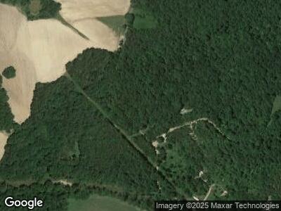
1710 Jack Sparks Rd Edmonton, KY 42129
Estimated Value: $21,192 - $131,000
--
Bed
--
Bath
320
Sq Ft
$252/Sq Ft
Est. Value
About This Home
This home is located at 1710 Jack Sparks Rd, Edmonton, KY 42129 and is currently estimated at $80,731, approximately $252 per square foot. 1710 Jack Sparks Rd is a home located in Metcalfe County with nearby schools including Metcalfe County Elementary School, Metcalfe County Middle School, and Metcalfe County High School.
Ownership History
Date
Name
Owned For
Owner Type
Purchase Details
Closed on
Apr 27, 2023
Sold by
Eaton Nell Depp Stark and Eaton Joseph D
Bought by
Bell Robert L and Bell Kelly P
Current Estimated Value
Purchase Details
Closed on
Aug 29, 2022
Sold by
County Of Metcalfe
Bought by
Tax Brake Ky Llc
Purchase Details
Closed on
May 12, 2005
Sold by
Bain R Eli
Bought by
Kerr Jacob and Kerr Timothy
Home Financials for this Owner
Home Financials are based on the most recent Mortgage that was taken out on this home.
Original Mortgage
$10,000
Interest Rate
5.98%
Mortgage Type
Unknown
Create a Home Valuation Report for This Property
The Home Valuation Report is an in-depth analysis detailing your home's value as well as a comparison with similar homes in the area
Home Values in the Area
Average Home Value in this Area
Purchase History
| Date | Buyer | Sale Price | Title Company |
|---|---|---|---|
| Bell Robert L | $212,000 | None Listed On Document | |
| Tax Brake Ky Llc | $18,000 | None Listed On Document | |
| Kerr Jacob | $10,200 | None Available |
Source: Public Records
Mortgage History
| Date | Status | Borrower | Loan Amount |
|---|---|---|---|
| Previous Owner | Sba Towers Vii Llc | $0 | |
| Previous Owner | Kerr Jacob | $14,203 | |
| Previous Owner | Kerr Jacob | $10,000 |
Source: Public Records
Tax History Compared to Growth
Tax History
| Year | Tax Paid | Tax Assessment Tax Assessment Total Assessment is a certain percentage of the fair market value that is determined by local assessors to be the total taxable value of land and additions on the property. | Land | Improvement |
|---|---|---|---|---|
| 2024 | $183 | $18,000 | $0 | $0 |
| 2023 | $181 | $18,000 | $0 | $0 |
| 2022 | $183 | $18,000 | $0 | $0 |
| 2021 | $186 | $18,000 | $0 | $0 |
| 2020 | $190 | $18,000 | $0 | $0 |
| 2019 | $193 | $18,000 | $0 | $0 |
| 2018 | $190 | $18,000 | $0 | $0 |
| 2017 | $187 | $18,000 | $0 | $0 |
| 2016 | $186 | $18,000 | $0 | $0 |
| 2015 | -- | $24,000 | $6,000 | $18,000 |
Source: Public Records
Map
Nearby Homes
- 257 Hubbard Cemetery Rd
- Ac Old Glasgow Rd
- 1900 Columbia Rd
- 0 Preston Sullivan Rd Unit 23160457
- 10 Preston Sullivan Rd Unit Tract 2
- 10 Preston Sullivan Rd Unit Tract 10
- 1578 Weed-Keltner Rd
- 2144 Greensburg Rd
- 1188 Breeding Rd
- 104 Harris St
- 11160 Greensburg Rd
- 0 Hwy 533 Unit 22745721
- 0 Hwy 533 Unit 11440444
- AC Rollin Blaydes Rd Unit Adams Ridge Rd
- 201 Greensburg St
- 401 Muncie Ct
- 5100 Subtle Rd
- 0 Chestnut Grove Rd Unit SC46674
- 25 Leatherwood Church Rd
- 0 Burdette Rd
- 1710 Jack Sparks Rd
- 1650 Jack Sparks Rd
- AC Jack Sparks Rd
- 1923 Jack Sparks Rd
- 1380 Hubbard Cemetery Rd
- 462 Knight Rd
- 2485 Jack Sparks Rd
- 2514 Jack Sparks Rd
- 455 Hubbard Cemetery Rd
- 2303 Bridgeport Rd
- 2303 Bridgeport Rd
- 2469 Bridgeport Rd
- 977 E Fork Rd
- 1012 E Fork Rd
- 616 Hubbard Cemetery Rd
- 1594 Granville Sexton Rd
- 67 Hitchens Rd
- 2304 Bridgeport Rd
