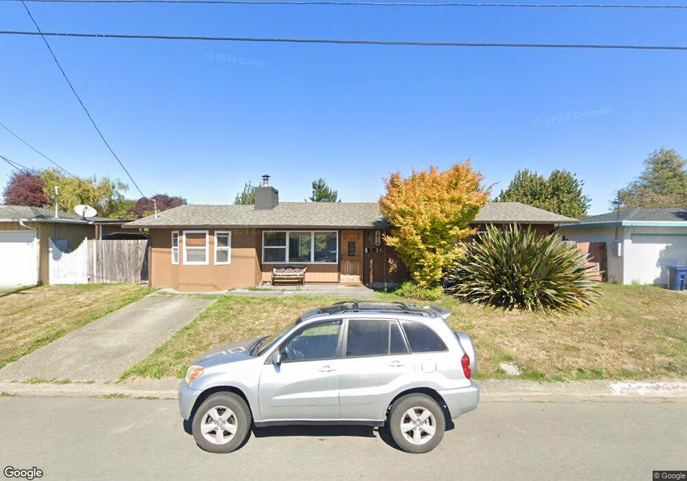
1710 Stromberg Ave Arcata, CA 95521
Westwood-Vasside NeighborhoodEstimated Value: $422,566 - $497,000
3
Beds
2
Baths
1,500
Sq Ft
$308/Sq Ft
Est. Value
About This Home
This home is located at 1710 Stromberg Ave, Arcata, CA 95521 and is currently estimated at $461,392, approximately $307 per square foot. 1710 Stromberg Ave is a home located in Humboldt County with nearby schools including Arcata Elementary School, Sunny Brae Middle School, and Arcata High School.
Ownership History
Date
Name
Owned For
Owner Type
Purchase Details
Closed on
Aug 15, 2019
Sold by
Uso Rachel May and Lewis Jon W
Bought by
Uso Rachel May and Lewis Jon W
Current Estimated Value
Purchase Details
Closed on
Jul 6, 1998
Sold by
Lowenhaupt Rachel M and Lowenhaupt Rachel M
Bought by
Ayuso Rachel M
Create a Home Valuation Report for This Property
The Home Valuation Report is an in-depth analysis detailing your home's value as well as a comparison with similar homes in the area
Home Values in the Area
Average Home Value in this Area
Purchase History
| Date | Buyer | Sale Price | Title Company |
|---|---|---|---|
| Uso Rachel May | -- | None Available | |
| Ayuso Rachel M | -- | Humboldt Land Title Company |
Source: Public Records
Tax History Compared to Growth
Tax History
| Year | Tax Paid | Tax Assessment Tax Assessment Total Assessment is a certain percentage of the fair market value that is determined by local assessors to be the total taxable value of land and additions on the property. | Land | Improvement |
|---|---|---|---|---|
| 2025 | $2,435 | $199,345 | $79,733 | $119,612 |
| 2024 | $2,435 | $195,437 | $78,170 | $117,267 |
| 2023 | $2,387 | $191,606 | $76,638 | $114,968 |
| 2022 | $2,428 | $187,850 | $75,136 | $112,714 |
| 2021 | $3,271 | $272,082 | $116,831 | $155,251 |
| 2020 | $2,235 | $182,279 | $72,908 | $109,371 |
| 2019 | $2,166 | $178,706 | $71,479 | $107,227 |
| 2018 | $2,118 | $175,203 | $70,078 | $105,125 |
| 2017 | $2,073 | $171,768 | $68,704 | $103,064 |
| 2016 | $2,001 | $168,401 | $67,357 | $101,044 |
| 2015 | $1,980 | $165,873 | $66,346 | $99,527 |
| 2014 | $1,977 | $162,625 | $65,047 | $97,578 |
Source: Public Records
Map
Nearby Homes
- 1254 Mccallum Cir
- 2155 Western Ave
- 3028 Alliance Rd
- 2700 Meadow Creek Way
- 3659 Spear Ave
- 2565 Todd Ct
- 429 Evergreen Ave
- 356 California Ave
- 2910 Greenbriar Ln
- 402 Tanglewood Rd
- 3763 Coombs Ct
- 119 Sylva St
- 113 Sylva St
- 2203 Appaloosa Ln
- 2078 Shetland Ln
- 1016 F St
- 632 9th St
- 1346 Diamond Dr
- 120 & 120a 13th St
- 1243 Devlin Ct
- 1700 Stromberg Ave
- 1720 Stromberg Ave
- 1680 Stromberg Ave
- 1715 Stromberg Ave
- 1730 Stromberg Ave
- 2600 Susan Ave
- 2600 Susan St
- 1723 Stromberg Ave
- 2557 Chestnut Place
- 2533 Chestnut Place
- 1670 Stromberg Ave
- 2461 Chestnut Place
- 1740 Stromberg Ave
- 1733 Stromberg Ave
- 1658 Stromberg Ave
- 2620 Susan Ave
- 2605 Susan Ave
- 2620 Susan St
- 1714 Roberts Way
- 1724 Roberts Way