Estimated Value: $187,000 - $262,000
3
Beds
2
Baths
1,411
Sq Ft
$161/Sq Ft
Est. Value
About This Home
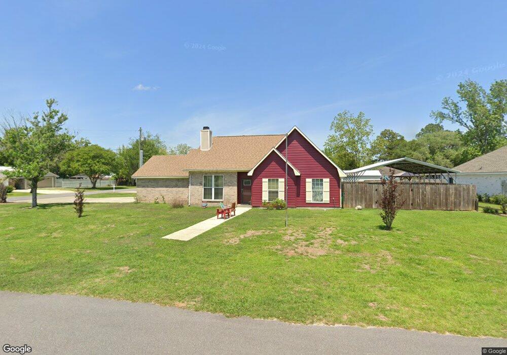
This home is located at 1711 S Bay St, Foley, AL 36535 and is currently estimated at $227,520, approximately $161 per square foot. 1711 S Bay St is a home located in Baldwin County with nearby schools including Florence Mathis Elementary School, Foley Middle School, and Foley High School.
Ownership History
Date
Name
Owned For
Owner Type
Purchase Details
Closed on
Jan 25, 2022
Sold by
Smith Scott J and Smith Judith M
Bought by
Hamby Michael
Current Estimated Value
Purchase Details
Closed on
Jan 4, 2018
Sold by
Smith Scott J and Smith Judith M
Bought by
Hamby Veldon and Hamby Dorreen
Purchase Details
Closed on
Dec 23, 2015
Sold by
Grace Thomas Boswell
Bought by
Smith Scott J and Smith Judith M
Purchase Details
Closed on
Aug 25, 2015
Sold by
Grace Sara B
Bought by
Grace Thomas Boswell
Purchase Details
Closed on
Jul 16, 2009
Sold by
Drumm Joshua L and Drumm Natalie R
Bought by
Grace Jack O and Grace Sara B
Create a Home Valuation Report for This Property
The Home Valuation Report is an in-depth analysis detailing your home's value as well as a comparison with similar homes in the area
Home Values in the Area
Average Home Value in this Area
Purchase History
| Date | Buyer | Sale Price | Title Company |
|---|---|---|---|
| Hamby Michael | $140,000 | Land Title | |
| Hamby Veldon | $140,000 | None Available | |
| Smith Scott J | $100,000 | None Available | |
| Grace Thomas Boswell | $99,500 | None Available | |
| Grace Jack O | -- | Professional Land Title Inc |
Source: Public Records
Tax History Compared to Growth
Tax History
| Year | Tax Paid | Tax Assessment Tax Assessment Total Assessment is a certain percentage of the fair market value that is determined by local assessors to be the total taxable value of land and additions on the property. | Land | Improvement |
|---|---|---|---|---|
| 2024 | $566 | $18,520 | $3,900 | $14,620 |
| 2023 | $581 | $18,980 | $4,600 | $14,380 |
| 2022 | $488 | $16,160 | $0 | $0 |
| 2021 | $421 | $14,120 | $0 | $0 |
| 2020 | $369 | $12,560 | $0 | $0 |
| 2019 | $356 | $12,140 | $0 | $0 |
| 2018 | $753 | $22,820 | $0 | $0 |
| 2017 | $722 | $21,880 | $0 | $0 |
| 2016 | $280 | $9,860 | $0 | $0 |
| 2015 | $327 | $9,920 | $0 | $0 |
| 2014 | $294 | $8,900 | $0 | $0 |
| 2013 | -- | $8,640 | $0 | $0 |
Source: Public Records
Map
Nearby Homes
- 0 S Poplar St Unit 340047
- 1720 Firefly Ln
- Plan 1525 at Heritage Landing
- Plan 1348 at Heritage Landing
- Plan 1635-C at Heritage Landing
- Plan 2200 at Heritage Landing
- Plan 1820-2 at Heritage Landing
- Plan 1425 at Heritage Landing
- Plan 1717 at Heritage Landing
- Plan 1900 at Heritage Landing
- Plan 2020 at Heritage Landing
- 1093 Pheasant Cir
- 1096 Pheasant Cir
- 1420 Plymouth Dr
- 624 Mayflower Dr
- 627 Mayflower Dr
- 1123 Pheasant Cir
- 628 Mayflower Dr
- 632 Mayflower Dr
- 635 Mayflower Dr
- 1707 S Bay St
- 1 Windgate Ct
- 1801 Windgate Ct
- 1801 S Bay St
- 408 E Lawson Ave
- 1706 S Bay St
- 1708 S Bay St
- 3 Windgate Ct
- 2 Windgate Ct
- 1710 S Bay St
- 5 Windgate Ct
- 410 E East Lawson Ave
- 1700 S Bay St
- 0 Canterberry Cir
- 4 Windgate Ct
- 6 Windgate Ct
- 412 E Lawson Ave Unit 1
- 407 E Lawson Ave
- 1804 S Bay St
- 3 Martin Cir