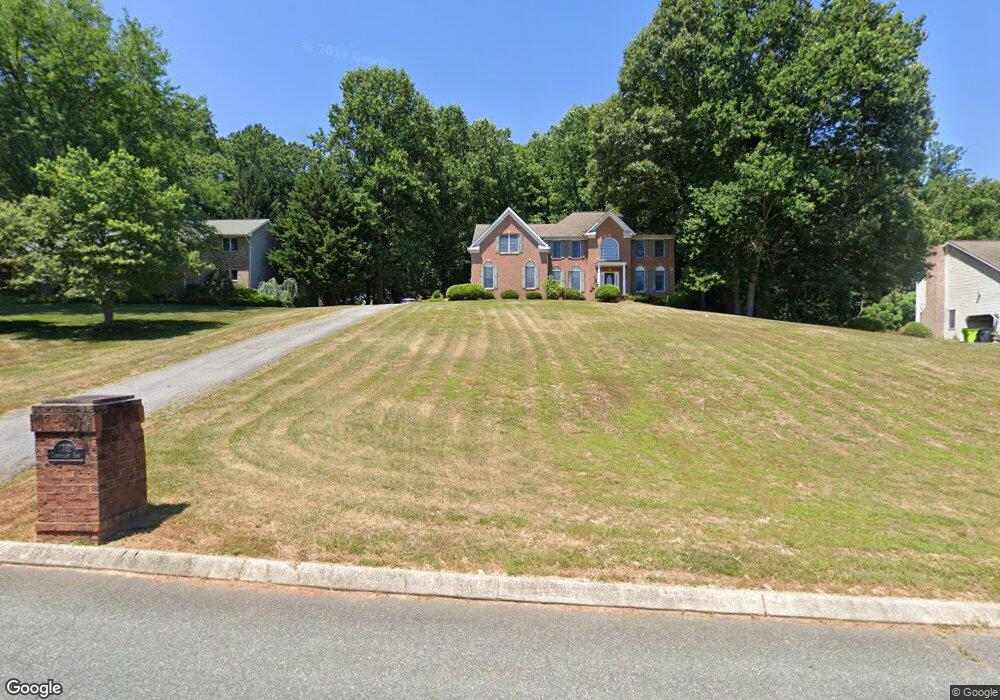
1712 Cannongate Rd Forest Hill, MD 21050
Estimated Value: $615,000 - $857,000
--
Bed
4
Baths
3,305
Sq Ft
$229/Sq Ft
Est. Value
About This Home
This home is located at 1712 Cannongate Rd, Forest Hill, MD 21050 and is currently estimated at $756,738, approximately $228 per square foot. 1712 Cannongate Rd is a home located in Harford County with nearby schools including Forest Lakes Elementary School, Fallston Middle School, and Fallston High School.
Ownership History
Date
Name
Owned For
Owner Type
Purchase Details
Closed on
Jan 19, 2005
Sold by
Gordon Brian Scott
Bought by
Bosworth Ii Michael A and Bosworth Denise M
Current Estimated Value
Home Financials for this Owner
Home Financials are based on the most recent Mortgage that was taken out on this home.
Original Mortgage
$11,000
Interest Rate
6.08%
Mortgage Type
Credit Line Revolving
Purchase Details
Closed on
Apr 20, 1998
Sold by
Trinity Home Builders Inc
Bought by
Gordon Brian Scott and Gordon Jane K
Create a Home Valuation Report for This Property
The Home Valuation Report is an in-depth analysis detailing your home's value as well as a comparison with similar homes in the area
Home Values in the Area
Average Home Value in this Area
Purchase History
| Date | Buyer | Sale Price | Title Company |
|---|---|---|---|
| Bosworth Ii Michael A | $550,000 | -- | |
| Gordon Brian Scott | $320,000 | -- |
Source: Public Records
Mortgage History
| Date | Status | Borrower | Loan Amount |
|---|---|---|---|
| Closed | Bosworth Ii Michael A | $11,000 | |
| Closed | Gordon Brian Scott | -- |
Source: Public Records
Tax History Compared to Growth
Tax History
| Year | Tax Paid | Tax Assessment Tax Assessment Total Assessment is a certain percentage of the fair market value that is determined by local assessors to be the total taxable value of land and additions on the property. | Land | Improvement |
|---|---|---|---|---|
| 2025 | $5,937 | $571,267 | $0 | $0 |
| 2024 | $5,937 | $539,200 | $137,400 | $401,800 |
| 2023 | $5,839 | $530,200 | $0 | $0 |
| 2022 | $5,741 | $521,200 | $0 | $0 |
| 2021 | $5,971 | $512,200 | $137,400 | $374,800 |
| 2020 | $5,971 | $512,200 | $137,400 | $374,800 |
| 2019 | $5,971 | $512,200 | $137,400 | $374,800 |
| 2018 | $5,967 | $516,500 | $129,000 | $387,500 |
| 2017 | $5,967 | $516,500 | $0 | $0 |
| 2016 | -- | $516,500 | $0 | $0 |
| 2015 | $6,510 | $522,700 | $0 | $0 |
| 2014 | $6,510 | $522,700 | $0 | $0 |
Source: Public Records
Map
Nearby Homes
- 1738 Shanwick Rd
- 1775 Pleasantville Rd
- 1701 Ingleside Rd
- 1932 Pleasantville Rd
- 1702 Lasalle Rd
- 600 Rock Spring Church Rd
- 2033 Packard Dr
- 2011 Fallsgrove Way
- 1705 Moonriver Ct
- 2401 Scotlon Ct
- 1605 Kiersten Ct
- 2286 Phillips Mill Rd
- 308 Rock Spring Church Rd
- Lot 5 Arden Dr
- 916 Delray Dr
- 2204 Arden Dr
- 1345 Cooptown Rd
- 2208 Arden Dr
- 1991 Gulfstream Ct
- 2326 Willow Vale Dr
- 1714 Cannongate Rd
- 1710 Cannongate Rd
- 1731 Cosner Rd
- 1716 Cannongate Rd
- 1715 Cannongate Rd
- 1717 Cannongate Rd
- 1718 Cannongate Rd
- 1729 Cosner Rd
- 1719 Cannongate Rd
- 1713 Cannongate Rd
- 1708 Cannongate Rd
- 1720 Cannongate Rd
- 1711 Cannongate Rd
- 1721 Cannongate Rd
- 1722 Cannongate Rd
- 1727 Cosner Rd
- 1709 Cannongate Rd
- 1810 High Point Rd
- 1724 Cannongate Rd
- 1725 Cannongate Rd