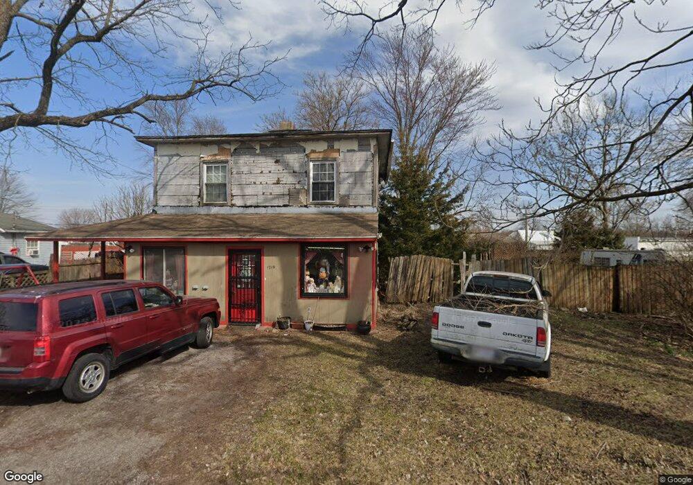
1719 Bank St Findlay, OH 45840
Estimated Value: $156,000 - $217,000
3
Beds
2
Baths
1,474
Sq Ft
$120/Sq Ft
Est. Value
About This Home
This home is located at 1719 Bank St, Findlay, OH 45840 and is currently estimated at $177,000, approximately $120 per square foot. 1719 Bank St is a home located in Hancock County with nearby schools including Jefferson Elementary School, Chamberlin Hill Elementary School, and Donnell Middle School.
Ownership History
Date
Name
Owned For
Owner Type
Purchase Details
Closed on
Jul 29, 2021
Sold by
Thomas Alan R
Bought by
Slough Joshua
Current Estimated Value
Home Financials for this Owner
Home Financials are based on the most recent Mortgage that was taken out on this home.
Original Mortgage
$440,000
Interest Rate
2.93%
Mortgage Type
Construction
Purchase Details
Closed on
Jun 18, 1985
Bought by
Beck Timothy W and Beck Shirley A
Purchase Details
Closed on
Dec 5, 1984
Bought by
Wilch Lester P
Create a Home Valuation Report for This Property
The Home Valuation Report is an in-depth analysis detailing your home's value as well as a comparison with similar homes in the area
Home Values in the Area
Average Home Value in this Area
Purchase History
| Date | Buyer | Sale Price | Title Company |
|---|---|---|---|
| Slough Joshua | -- | Whitman Title | |
| Beck Timothy W | $7,000 | -- | |
| Wilch Lester P | -- | -- |
Source: Public Records
Mortgage History
| Date | Status | Borrower | Loan Amount |
|---|---|---|---|
| Closed | Slough Joshua | $440,000 |
Source: Public Records
Tax History Compared to Growth
Tax History
| Year | Tax Paid | Tax Assessment Tax Assessment Total Assessment is a certain percentage of the fair market value that is determined by local assessors to be the total taxable value of land and additions on the property. | Land | Improvement |
|---|---|---|---|---|
| 2024 | $239 | $16,530 | $3,550 | $12,980 |
| 2023 | $262 | $16,530 | $3,550 | $12,980 |
| 2022 | $276 | $16,530 | $3,550 | $12,980 |
| 2021 | $328 | $8,070 | $3,320 | $4,750 |
| 2020 | $328 | $8,070 | $3,320 | $4,750 |
| 2019 | $322 | $8,070 | $3,320 | $4,750 |
| 2018 | $307 | $7,010 | $2,880 | $4,130 |
| 2017 | $305 | $7,010 | $2,880 | $4,130 |
| 2016 | $436 | $7,010 | $2,880 | $4,130 |
| 2015 | $220 | $5,030 | $2,170 | $2,860 |
| 2014 | $220 | $5,030 | $2,170 | $2,860 |
| 2012 | $225 | $5,030 | $2,170 | $2,860 |
Source: Public Records
Map
Nearby Homes
- 1727 Washington Ave
- 804 6th St
- 211 Fairlawn Place
- 1705 S Main St
- 1621 S Main St
- 1726 Eastview Dr
- 200 E Edgar Ave
- 242 E Yates Ave
- 1709 Eastview Dr
- 1008 Eastview Dr
- 123 Glendale Ave
- 1109 Park St
- 1011 Stall Dr
- 420 1st St
- 1200 5th St
- 1421 Hurd Ave
- 1109 Brookside Dr
- 1006 Selby St
- 202 Hancock St
- 0 Blanchard Ave
- 1719 Bank St
- 1715 Bank St
- 1709 Bank St
- 1718 S Blanchard St
- 1726 S Blanchard St
- 1704 S Blanchard St
- 1701 Bank St
- 1720 Sherry St
- 1708 Sherry St
- 1702 Sherry St
- 1740 S Blanchard St
- 1704 Sherry St
- 1620 S Blanchard St
- 1700 Sherry St
- 420 E Pearl St
- 1630 Sherry St
- 1601 Sherry St
- 1618 S Blanchard St
- 503 E Pearl St
- 1609 Bank St