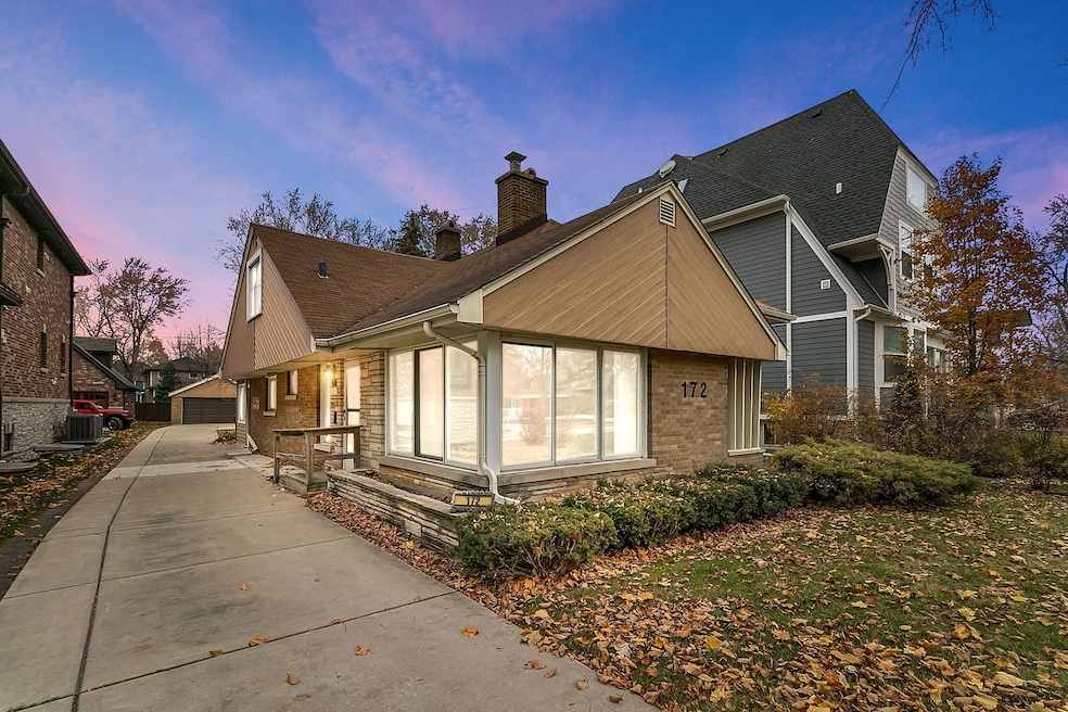
172 Olmsted Rd Riverside, IL 60546
Estimated payment $2,785/month
Highlights
- Hot Property
- Property is near a park
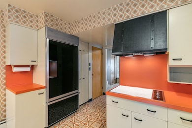
- Double Oven
- Central Elementary School Rated A
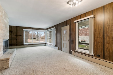
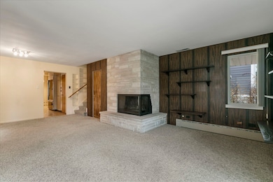
- Living Room with Fireplace
- Laundry Room
About This Home
Discover the charm of historic Riverside with this wonderful opportunity! Ideally located near downtown Riverside, scenic walking paths along Riverside Road, and the beautiful Des Plaines River, this home offers convenience and character. Featuring three bedrooms, 1.5 bathrooms, a kitchen with eating space, and a sunroom overlooking the backyard, it's perfect for comfortable living. Additional highlights include a two-car garage with a newer concrete driveway, a generator, 2 fireplaces, updated circuit breaker box, and drain tile for peace of mind. With solid bones and endless potential, this property is being sold "as is"-a fantastic chance for the new owner to make it their own. Don't miss out on this rare find in one of Riverside's most desirable locations!
Home Details
Home Type
- Single Family
Est. Annual Taxes
- $10,132
Year Built
- Built in 1953
Lot Details
- Lot Dimensions are 50 x 228.68 x 32.82 x 230.20
- Paved or Partially Paved Lot
Parking
- 2 Car Garage
- Driveway
Home Design
- Split Level Home
- Tri-Level Property
- Brick Exterior Construction
- Asphalt Roof
Interior Spaces
- 1,753 Sq Ft Home
- Ceiling Fan
- Family Room
- Living Room with Fireplace
- 2 Fireplaces
- Combination Dining and Living Room
- Pull Down Stairs to Attic
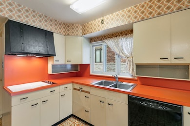
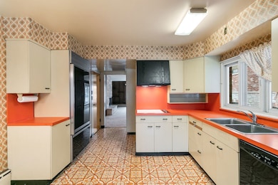
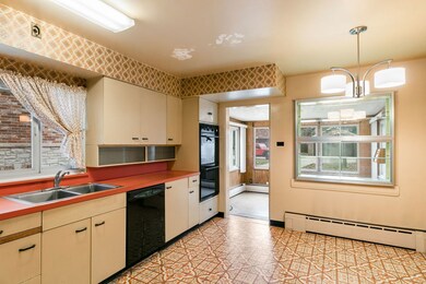
Kitchen
- Double Oven
- High End Refrigerator
- Dishwasher
Flooring
- Carpet
- Vinyl
Bedrooms and Bathrooms
- 3 Bedrooms
- 3 Potential Bedrooms
Laundry
- Laundry Room
- Dryer
- Washer
- Sink Near Laundry
Basement
- Partial Basement
- Sump Pump
- Fireplace in Basement
Location
- Property is near a park
Schools
- L J Hauser Junior High School
- Riverside Brookfield Twp Senior High School
Utilities
- Central Air
- Baseboard Heating
- Heating System Uses Natural Gas
- Lake Michigan Water
Listing and Financial Details
- Senior Tax Exemptions
- Homeowner Tax Exemptions
- Other Tax Exemptions
Map
Home Values in the Area
Average Home Value in this Area
Tax History
| Year | Tax Paid | Tax Assessment Tax Assessment Total Assessment is a certain percentage of the fair market value that is determined by local assessors to be the total taxable value of land and additions on the property. | Land | Improvement |
|---|---|---|---|---|
| 2024 | $9,715 | $37,000 | $8,868 | $28,132 |
| 2023 | $10,224 | $37,000 | $8,868 | $28,132 |
| 2022 | $10,224 | $33,536 | $7,760 | $25,776 |
| 2021 | $10,136 | $33,534 | $7,759 | $25,775 |
| 2020 | $9,950 | $33,534 | $7,759 | $25,775 |
| 2019 | $6,737 | $25,313 | $7,094 | $18,219 |
| 2018 | $6,535 | $25,313 | $7,094 | $18,219 |
| 2017 | $6,359 | $25,313 | $7,094 | $18,219 |
| 2016 | $6,598 | $23,015 | $6,207 | $16,808 |
| 2015 | $6,372 | $23,015 | $6,207 | $16,808 |
| 2014 | $6,295 | $23,015 | $6,207 | $16,808 |
| 2013 | $6,985 | $26,899 | $6,207 | $20,692 |
Property History
| Date | Event | Price | List to Sale | Price per Sq Ft |
|---|---|---|---|---|
| 12/08/2025 12/08/25 | For Sale | $370,000 | -- | $211 / Sq Ft |
Purchase History
| Date | Type | Sale Price | Title Company |
|---|---|---|---|
| Interfamily Deed Transfer | -- | None Available |
Source: Midwest Real Estate Data (MRED)
MLS Number: 12529506
APN: 15-36-403-050-0000
Disclaimer: Certain information contained herein is derived from information provided by parties other than Homes.com. All information provided is deemed reliable, but is not guaranteed to be accurate and should be independently verified.
![]() Based on information submitted to the MLS GRID. All data is obtained from various sources and may not have been verified by broker or MLS GRID. Supplied Open House Information is subject to change without notice. All information should be independently reviewed and verified for accuracy. Properties may or may not be listed by the office/agent presenting the information. Some IDX listings have been excluded from this website.
Based on information submitted to the MLS GRID. All data is obtained from various sources and may not have been verified by broker or MLS GRID. Supplied Open House Information is subject to change without notice. All information should be independently reviewed and verified for accuracy. Properties may or may not be listed by the office/agent presenting the information. Some IDX listings have been excluded from this website.
The Digital Millennium Copyright Act of 1998, 17 U.S.C. § 512 (the “DMCA”) provides recourse for copyright owners who believe that material appearing on the Internet infringes their rights under U.S. copyright law. If you believe in good faith that any content or material made available in connection with our website or services infringes your copyright, you (or your agent) may send us a notice requesting that the content or material be removed, or access to it blocked.
Notices must be sent in writing by email to DMCAnotice@MLSGrid.com.
The DMCA requires that your notice of alleged copyright infringement include the following information:
(1) description of the copyrighted work that is the subject of claimed infringement;
(2) description of the alleged infringing content and information sufficient to permit us to locate the content;
(3) contact information for you, including your address, telephone number and email address;
(4) a statement by you that you have a good faith belief that the content in the manner complained of is not authorized by the copyright owner, or its agent, or by the operation of any law;
(5) a statement by you, signed under penalty of perjury, that the information in the notification is accurate and that you have the authority to enforce the copyrights that are claimed to be infringed; and
(6) a physical or electronic signature of the copyright owner or a person authorized to act on the copyright owner’s behalf. Failure to include all of the above information may result in the delay of the processing of your complaint.
- 68 Lawton Rd
- 10 E Burlington St Unit 3C
- 7335 Oakwood Ave Unit P-10
- 7335 Oakwood Ave Unit P-12
- 7335 Oakwood Ave Unit P-8
- 7335 Oakwood Ave Unit P-11
- 7335 Oakwood Ave Unit P-14
- 7316 40th St Unit P-9
- 7316 40th St Unit P-10
- 7316 40th St Unit P-13
- 56 Forest Ave Unit 1N
- 78 Pine Ave
- 269 Shenstone Rd
- 3515 S Harlem Ave Unit 1B
- 3731 Maple Ave
- 7825 41st Place
- 3816 Wisconsin Ave
- 4147 Gage Ave
- 3829 Wisconsin Ave
- 108 Lincoln Ave Unit 2B
- 7634 Ogden Ave
- 3 E Quincy St Unit 2
- 153 Barrypoint Rd Unit Barry1stfloor
- 50 Forest Ave Unit GS
- 3537 S Harlem Ave Unit 2
- 3529 S Harlem Ave Unit 8
- 96 Pine Ave Unit 1
- 8129 Ogden Ave Unit 1F
- 4238 Joliet Ave Unit 1R
- 192 Waubansee Rd
- 4300 Maple Ave Unit 1
- 3014 Harlem Ave Unit 1
- 4313 S Harlem Ave Unit 3
- 4343 Wisconsin Ave Unit 3
- 7918 45th St Unit W1
- 3800 Euclid Ave
- 3303 Grove Ave Unit 304
- 8223 W 30th St
- 3542 Wesley Ave
- 3832 East Ave
