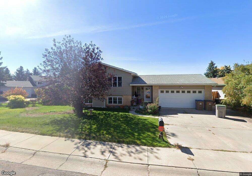
1720 W Hill Rd Laramie, WY 82072
Estimated Value: $402,000 - $425,000
4
Beds
2
Baths
1,064
Sq Ft
$388/Sq Ft
Est. Value
About This Home
This home is located at 1720 W Hill Rd, Laramie, WY 82072 and is currently estimated at $413,010, approximately $388 per square foot. 1720 W Hill Rd is a home located in Albany County with nearby schools including Slade Elementary School, Laramie Middle School, and Laramie High School.
Ownership History
Date
Name
Owned For
Owner Type
Purchase Details
Closed on
Mar 17, 2011
Sold by
Shannon Daniel J
Bought by
Williford Jason Scot and Williford Cynthia Danielle Michele
Current Estimated Value
Home Financials for this Owner
Home Financials are based on the most recent Mortgage that was taken out on this home.
Original Mortgage
$188,000
Outstanding Balance
$129,114
Interest Rate
4.78%
Mortgage Type
New Conventional
Estimated Equity
$283,896
Create a Home Valuation Report for This Property
The Home Valuation Report is an in-depth analysis detailing your home's value as well as a comparison with similar homes in the area
Purchase History
| Date | Buyer | Sale Price | Title Company |
|---|---|---|---|
| Williford Jason Scot | -- | None Available |
Source: Public Records
Mortgage History
| Date | Status | Borrower | Loan Amount |
|---|---|---|---|
| Open | Williford Jason Scot | $188,000 |
Source: Public Records
Tax History
| Year | Tax Paid | Tax Assessment Tax Assessment Total Assessment is a certain percentage of the fair market value that is determined by local assessors to be the total taxable value of land and additions on the property. | Land | Improvement |
|---|---|---|---|---|
| 2025 | $2,541 | $27,761 | $4,375 | $23,386 |
| 2024 | $2,541 | $34,811 | $5,609 | $29,202 |
| 2023 | $2,529 | $34,637 | $5,609 | $29,028 |
| 2022 | $2,330 | $31,922 | $5,967 | $25,955 |
| 2021 | $1,957 | $26,811 | $4,952 | $21,859 |
| 2020 | $1,773 | $24,291 | $4,301 | $19,990 |
| 2019 | $1,683 | $23,060 | $4,301 | $18,759 |
| 2018 | $1,830 | $25,073 | $4,301 | $20,772 |
| 2017 | $1,845 | $25,274 | $4,301 | $20,973 |
| 2016 | $1,900 | $26,024 | $4,301 | $21,723 |
| 2015 | $1,737 | $23,789 | $4,822 | $18,967 |
| 2014 | $1,666 | $22,820 | $0 | $0 |
Source: Public Records
Map
Nearby Homes
- 1708 W Hill Rd
- 1731 Downey St
- 1402 Mitchell St
- 1554 Henry Dr
- 1283 N 18th St
- 1167 N 18th St
- 1251 N 15th St Unit J
- 1259 N 15th St Unit G
- 16.26 Acres N 15th St
- 1257 N 15th St Unit H
- 1864 Dillon St
- 1315 Mill St
- 1003 W Hill Rd
- 1215 E Baker St
- 2454 N 13th St
- 1005 Shield St
- 1223 E Shields St Unit 1,2,3
- 716 Mitchell St
- 1103 E Canby St
- 707 Mitchell St
- 1766 N 18th St
- 1714 W Hill Rd
- 1708 Quot;w" Hill Rd
- 1762 N 18th St
- 1719 &Quot;w" Hill Rd
- 1719 W Hill Rd
- 1721 Mitchell St
- 1801 W Hill Rd
- 1702 W Hill Rd
- 1713 Mitchell St
- 1733 Mitchell St
- 1707 W Hill Rd
- 1707 Mitchell St
- 1767 N 18th St
- 1819 W Hill Rd
- 1807 W Hill Rd
- 1626 W Hill Rd
- 1763 N 18th St
- 1687 Coughlin St
- 1720 Downey St