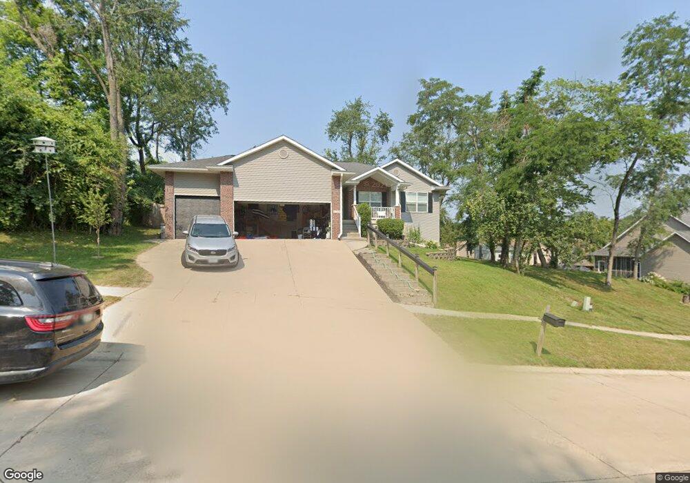
1722 Aaron Dr NW Cedar Rapids, IA 52405
Estimated Value: $351,000 - $404,000
4
Beds
1
Bath
2,799
Sq Ft
$134/Sq Ft
Est. Value
About This Home
This home is located at 1722 Aaron Dr NW, Cedar Rapids, IA 52405 and is currently estimated at $375,883, approximately $134 per square foot. 1722 Aaron Dr NW is a home located in Linn County with nearby schools including Maple Grove Elementary School, North Middletown Elementary School, and Ponderosa Elementary School.
Ownership History
Date
Name
Owned For
Owner Type
Purchase Details
Closed on
May 6, 2015
Sold by
Huggins Nicolas A
Bought by
Ealy Casey M and Ealy Emily R
Current Estimated Value
Home Financials for this Owner
Home Financials are based on the most recent Mortgage that was taken out on this home.
Original Mortgage
$180,800
Outstanding Balance
$138,978
Interest Rate
3.62%
Mortgage Type
Adjustable Rate Mortgage/ARM
Estimated Equity
$236,905
Purchase Details
Closed on
Apr 14, 2011
Sold by
Powers Carl Christopher and Powers Anne E
Bought by
Huggins Nicholas A
Home Financials for this Owner
Home Financials are based on the most recent Mortgage that was taken out on this home.
Original Mortgage
$189,000
Interest Rate
4%
Mortgage Type
New Conventional
Purchase Details
Closed on
May 28, 2008
Sold by
Humiston Jeffrey and Humiston Gretchen A
Bought by
Powers Anne E and Powers Carl Christopher
Home Financials for this Owner
Home Financials are based on the most recent Mortgage that was taken out on this home.
Original Mortgage
$179,200
Interest Rate
4.75%
Mortgage Type
Unknown
Purchase Details
Closed on
Jun 11, 2007
Sold by
Swenson John A and Swenson Aileen B
Bought by
Humiston Jeffrey and Humiston Gretchen A
Home Financials for this Owner
Home Financials are based on the most recent Mortgage that was taken out on this home.
Original Mortgage
$175,920
Interest Rate
5.12%
Mortgage Type
New Conventional
Purchase Details
Closed on
Aug 23, 2006
Sold by
Mckenzie Christopher K and Mckenzie Kimberly A
Bought by
Swenson John A and Swenson Aileen B
Home Financials for this Owner
Home Financials are based on the most recent Mortgage that was taken out on this home.
Original Mortgage
$160,500
Interest Rate
6.78%
Mortgage Type
Unknown
Purchase Details
Closed on
Mar 6, 2003
Sold by
Gustafson Randy and Gustafson Kay M
Bought by
Mckenzie Christopher K and Mckenzie Kimberly A
Home Financials for this Owner
Home Financials are based on the most recent Mortgage that was taken out on this home.
Original Mortgage
$183,000
Interest Rate
6%
Mortgage Type
VA
Create a Home Valuation Report for This Property
The Home Valuation Report is an in-depth analysis detailing your home's value as well as a comparison with similar homes in the area
Home Values in the Area
Average Home Value in this Area
Purchase History
| Date | Buyer | Sale Price | Title Company |
|---|---|---|---|
| Ealy Casey M | $226,000 | None Available | |
| Huggins Nicholas A | $209,500 | None Available | |
| Powers Anne E | $223,500 | None Available | |
| Humiston Jeffrey | $219,500 | None Available | |
| Swenson John A | $213,500 | None Available | |
| Mckenzie Christopher K | $182,500 | -- |
Source: Public Records
Mortgage History
| Date | Status | Borrower | Loan Amount |
|---|---|---|---|
| Open | Ealy Casey M | $180,800 | |
| Previous Owner | Huggins Nicholas A | $189,000 | |
| Previous Owner | Powers Anne E | $179,200 | |
| Previous Owner | Humiston Jeffrey | $175,920 | |
| Previous Owner | Swenson John A | $160,500 | |
| Previous Owner | Mckenzie Christopher K | $183,000 |
Source: Public Records
Tax History Compared to Growth
Tax History
| Year | Tax Paid | Tax Assessment Tax Assessment Total Assessment is a certain percentage of the fair market value that is determined by local assessors to be the total taxable value of land and additions on the property. | Land | Improvement |
|---|---|---|---|---|
| 2025 | $5,832 | $361,500 | $62,700 | $298,800 |
| 2024 | $6,098 | $342,100 | $55,300 | $286,800 |
| 2023 | $6,098 | $329,500 | $55,300 | $274,200 |
| 2022 | $5,428 | $289,100 | $47,900 | $241,200 |
| 2021 | $5,660 | $262,000 | $44,200 | $217,800 |
| 2020 | $5,510 | $256,500 | $36,900 | $219,600 |
| 2019 | $4,980 | $231,000 | $36,900 | $194,100 |
| 2018 | $4,842 | $231,000 | $36,900 | $194,100 |
| 2017 | $4,842 | $236,600 | $36,900 | $199,700 |
| 2016 | $4,888 | $230,000 | $36,900 | $193,100 |
| 2015 | $4,766 | $223,972 | $36,860 | $187,112 |
| 2014 | $4,766 | $223,972 | $36,860 | $187,112 |
| 2013 | $4,664 | $223,972 | $36,860 | $187,112 |
Source: Public Records
Map
Nearby Homes
- 3802 Richland Dr NW
- 1608 Morris Ave NW
- 327* Edgewood Rd NW
- 1613 Southview Dr NW
- 1733 Hillside Dr NW
- 1722 Gardner Dr NW
- 3313 Crestwood Dr NW
- 1322 Woodside Dr NW
- 2825 Schultz Dr NW
- 2801 Schultz Dr NW
- 3312 G Ave NW
- 0 River Bluffs Dr
- S River Bluffs Dr Unit S of River Bluffs Dr
- 2520 N Ave NW
- 912 29th St NW
- 4819 Fruitwood Ln NW
- 3507 E Ave NW Unit F
- 2623 Iris Ave NW
- 3509 E Ave NW Unit D
- 1410 Adair Ct SW Unit Lot 2
- 1728 Aaron Dr NW
- 1721 Wolf River Ln NW
- 1727 Wolf River Ln NW
- 1802 Aaron Dr NW
- 1719 Aaron Dr NW
- 1801 Wolf River Ln NW
- 1725 Aaron Dr NW
- 1805 Aaron Dr NW
- 1807 Wolf River Ln NW
- 1814 Aaron Dr NW
- 1726 Wolf River Ln NW
- 1813 Wolf River Ln NW
- 1800 Wolf River Ln NW
- 1817 Aaron Dr NW
- 1806 Wolf River Ln NW
- 1820 Aaron Dr NW
- 1819 Wolf River Ln NW
- 1812 Wolf River Ln NW
- 1823 Aaron Dr NW
- 1811 Greenlefe Dr NW