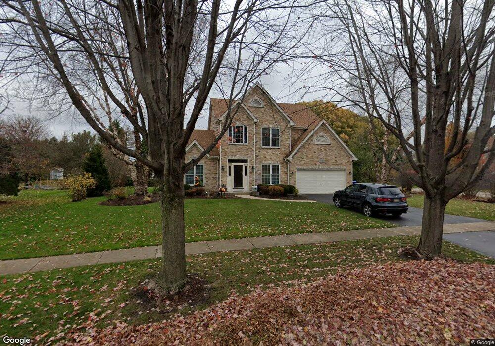
1723 Loran Dr Geneva, IL 60134
Eagle Brook NeighborhoodEstimated Value: $614,802 - $736,000
3
Beds
3
Baths
2,529
Sq Ft
$268/Sq Ft
Est. Value
About This Home
This home is located at 1723 Loran Dr, Geneva, IL 60134 and is currently estimated at $677,201, approximately $267 per square foot. 1723 Loran Dr is a home located in Kane County with nearby schools including Western Avenue Elementary School, Geneva Community High School, and St. Peter School.
Ownership History
Date
Name
Owned For
Owner Type
Purchase Details
Closed on
Dec 4, 2025
Sold by
Kawa Mark H and Kawa Wendy J
Bought by
Kawa Joint Trust and Kawa
Current Estimated Value
Purchase Details
Closed on
Sep 10, 1996
Sold by
American National Bk&Tr Co Of Chicago
Bought by
Kawa Mark H and Kawa Wendy J
Home Financials for this Owner
Home Financials are based on the most recent Mortgage that was taken out on this home.
Original Mortgage
$190,000
Interest Rate
7.93%
Mortgage Type
Balloon
Create a Home Valuation Report for This Property
The Home Valuation Report is an in-depth analysis detailing your home's value as well as a comparison with similar homes in the area
Home Values in the Area
Average Home Value in this Area
Purchase History
| Date | Buyer | Sale Price | Title Company |
|---|---|---|---|
| Kawa Joint Trust | -- | None Listed On Document | |
| Kawa Mark H | $279,000 | Chicago Title Insurance Co |
Source: Public Records
Mortgage History
| Date | Status | Borrower | Loan Amount |
|---|---|---|---|
| Previous Owner | Kawa Mark H | $190,000 |
Source: Public Records
Tax History
| Year | Tax Paid | Tax Assessment Tax Assessment Total Assessment is a certain percentage of the fair market value that is determined by local assessors to be the total taxable value of land and additions on the property. | Land | Improvement |
|---|---|---|---|---|
| 2024 | $11,533 | $165,765 | $48,569 | $117,196 |
| 2023 | $11,119 | $150,696 | $44,154 | $106,542 |
| 2022 | $10,843 | $140,026 | $41,028 | $98,998 |
| 2021 | $10,937 | $134,822 | $39,503 | $95,319 |
| 2020 | $10,813 | $132,764 | $38,900 | $93,864 |
| 2019 | $10,215 | $130,250 | $38,163 | $92,087 |
| 2018 | $10,945 | $138,850 | $41,855 | $96,995 |
| 2017 | $10,824 | $135,147 | $40,739 | $94,408 |
| 2016 | $11,876 | $144,432 | $40,188 | $104,244 |
| 2015 | -- | $124,028 | $38,209 | $85,819 |
| 2014 | -- | $122,860 | $38,209 | $84,651 |
| 2013 | -- | $122,860 | $38,209 | $84,651 |
Source: Public Records
Map
Nearby Homes
- 369 Fritz Ln
- 1736 Kaneville Rd
- 301 Country Club Place
- 999 Sunset Rd
- 1145 Keim Ct
- 629 Peck Rd
- 1580 Turnberry Ct
- 758 Riverbank Dr
- 2309 Sudbury Ln
- 839 S Randall Rd
- 1919 Sheffield Ln
- 1201 Ford St
- Unit 6A Prairie Grove Dr
- Unit 5B Prairie Grove Dr
- Unit 4A Prairie Grove Dr
- Unit 5A Prairie Grove Dr
- Unit 4B Prairie Grove Dr
- Unit 7A Prairie Grove Dr
- Unit 6C Prairie Grove Dr
- Unit 5C Prairie Grove Dr
- 1747 Loran Dr
- 730 Brigham Ct
- 1710 Loran Dr
- 1761 Loran Dr
- 1736 Loran Dr
- 1788 Loran Dr
- 1795 Loran Dr
- 710 Brigham Ct Unit 3
- 1577 Fargo Blvd
- 850 Brigham Way
- 839 Brigham Way
- 729 Brigham Ct
- 849 Brigham Way Unit 3
- 1569 Fargo Blvd Unit 2
- 700 Brigham Ct
- 860 Brigham Way
- 721 Brigham Ct Unit 3
- 1600 Fargo Blvd
- 1584 Fargo Blvd
- 1623 Kummer Ct
Your Personal Tour Guide
Ask me questions while you tour the home.