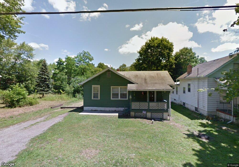
1725 Shaw Ave Youngstown, OH 44505
McGuffey Heights NeighborhoodEstimated Value: $41,518 - $77,000
2
Beds
1
Bath
704
Sq Ft
$79/Sq Ft
Est. Value
About This Home
This home is located at 1725 Shaw Ave, Youngstown, OH 44505 and is currently estimated at $55,880, approximately $79 per square foot. 1725 Shaw Ave is a home located in Mahoning County with nearby schools including M.L. King Elementary School, Williamson Elementary School, and East High School.
Ownership History
Date
Name
Owned For
Owner Type
Purchase Details
Closed on
Aug 25, 2023
Sold by
Barb Raymond J
Bought by
Edwards Derick
Current Estimated Value
Purchase Details
Closed on
Aug 12, 2022
Sold by
Barb Raymond J
Bought by
Waxter John G
Purchase Details
Closed on
Feb 22, 2022
Bought by
Barb Raymond J
Purchase Details
Closed on
Jun 12, 2018
Bought by
Barb Loraine M
Purchase Details
Closed on
Jan 20, 1999
Sold by
Walls Alice
Bought by
Stehnike Uwe J and Stehnike Judith A
Purchase Details
Closed on
Jun 11, 1979
Bought by
Walls Alice
Create a Home Valuation Report for This Property
The Home Valuation Report is an in-depth analysis detailing your home's value as well as a comparison with similar homes in the area
Home Values in the Area
Average Home Value in this Area
Purchase History
| Date | Buyer | Sale Price | Title Company |
|---|---|---|---|
| Edwards Derick | $4,000 | None Listed On Document | |
| Edwards Derick | $4,000 | None Listed On Document | |
| Waxter John G | -- | -- | |
| Barb Raymond J | -- | -- | |
| Barb Loraine M | -- | -- | |
| Stehnike Uwe J | $5,500 | -- | |
| Walls Alice | -- | -- |
Source: Public Records
Tax History Compared to Growth
Tax History
| Year | Tax Paid | Tax Assessment Tax Assessment Total Assessment is a certain percentage of the fair market value that is determined by local assessors to be the total taxable value of land and additions on the property. | Land | Improvement |
|---|---|---|---|---|
| 2024 | $159 | $3,280 | $540 | $2,740 |
| 2023 | $162 | $3,280 | $540 | $2,740 |
| 2022 | $110 | $1,700 | $470 | $1,230 |
| 2021 | $110 | $1,700 | $470 | $1,230 |
| 2020 | $110 | $1,700 | $470 | $1,230 |
| 2019 | $116 | $1,560 | $430 | $1,130 |
| 2018 | $114 | $1,560 | $430 | $1,130 |
| 2017 | $111 | $1,560 | $430 | $1,130 |
| 2016 | $110 | $1,670 | $430 | $1,240 |
| 2015 | $108 | $1,670 | $430 | $1,240 |
| 2014 | $107 | $1,670 | $430 | $1,240 |
| 2013 | $106 | $1,670 | $430 | $1,240 |
Source: Public Records
Map
Nearby Homes
- 1720 Jacobs Rd
- 1214 Brighton St
- 2051 Blair Ave
- V/L Jacobs Rd
- 1003 Liberty Rd
- 2951 Megan Cir
- 2831 Benford Ln
- 2954 Megan Cir
- 1325 Miami Ave
- 902 Miami St
- 1538 Republic Ave
- 665 Wendemere Dr
- 0 Homestead Rd
- 366 Westview Ave
- 663 Meadowland Dr
- 5843 Fairlawn Ave
- 405 Drake Ave
- 566 Sunshine Ave
- 227 Greeley Ln
- 279 Parish Ave
- 1717 Shaw Ave
- 1737 Shaw Ave
- 1715 Shaw Ave
- 1718 Shaw Ave
- 1726 Shaw Ave
- 1710 Shaw Ave
- 1701 Shaw Ave
- 1754 Shaw Ave
- 1717 Josephine St
- 1729 Josephine St
- 1709 Josephine St
- 2850 Karl St
- 2851 Karl St
- 2817 Karl St
- 1716 Josephine St
- 2916 Karl St
- 2803 Karl St
- 1720 Josephine St
- 2903 Wardle Ave
- 1730 Josephine St