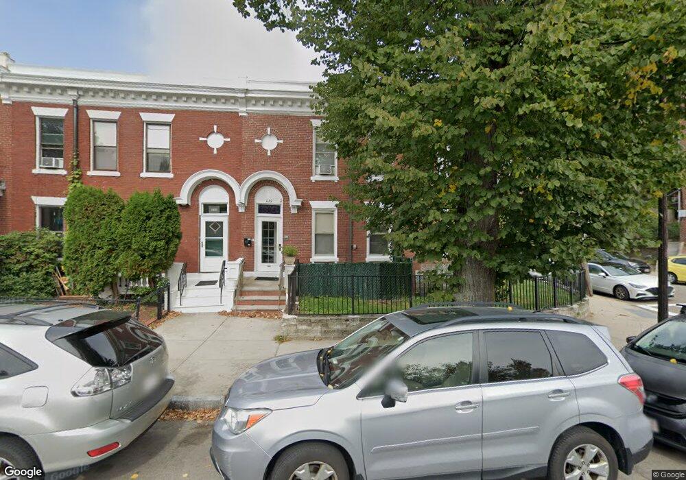
1729 Commonwealth Ave Brighton, MA 02135
Saint Elizabeths NeighborhoodEstimated Value: $1,351,000 - $1,775,288
4
Beds
3
Baths
2,397
Sq Ft
$632/Sq Ft
Est. Value
About This Home
This home is located at 1729 Commonwealth Ave, Brighton, MA 02135 and is currently estimated at $1,515,572, approximately $632 per square foot. 1729 Commonwealth Ave is a home located in Suffolk County with nearby schools including Boston Green Academy Horace Mann Charter School, Shaloh House Jewish Day School, and Torah Academy.
Ownership History
Date
Name
Owned For
Owner Type
Purchase Details
Closed on
Aug 9, 2017
Sold by
Primpas Joan and Estrada Luis A
Bought by
Int Boxer
Current Estimated Value
Purchase Details
Closed on
Apr 10, 2017
Sold by
Primpas Milias J
Bought by
Primpas Joan and Estrada Luis A
Purchase Details
Closed on
Apr 12, 2016
Sold by
Primpas Joan
Bought by
Primpas Joan and Estrada Luis A
Create a Home Valuation Report for This Property
The Home Valuation Report is an in-depth analysis detailing your home's value as well as a comparison with similar homes in the area
Home Values in the Area
Average Home Value in this Area
Purchase History
| Date | Buyer | Sale Price | Title Company |
|---|---|---|---|
| Int Boxer | -- | -- | |
| Primpas Joan | -- | -- | |
| Primpas Joan | -- | -- |
Source: Public Records
Tax History
| Year | Tax Paid | Tax Assessment Tax Assessment Total Assessment is a certain percentage of the fair market value that is determined by local assessors to be the total taxable value of land and additions on the property. | Land | Improvement |
|---|---|---|---|---|
| 2025 | $16,184 | $1,397,600 | $489,200 | $908,400 |
| 2024 | $15,185 | $1,393,100 | $421,800 | $971,300 |
| 2023 | $14,242 | $1,326,100 | $401,500 | $924,600 |
| 2022 | $14,289 | $1,313,300 | $397,600 | $915,700 |
| 2021 | $13,738 | $1,287,500 | $389,800 | $897,700 |
| 2020 | $12,401 | $1,174,300 | $370,000 | $804,300 |
| 2019 | $11,570 | $1,097,700 | $284,900 | $812,800 |
| 2018 | $10,955 | $1,045,300 | $284,900 | $760,400 |
| 2017 | $10,542 | $995,500 | $284,900 | $710,600 |
| 2016 | $9,779 | $889,000 | $284,900 | $604,100 |
| 2015 | $9,471 | $782,100 | $235,000 | $547,100 |
| 2014 | $8,548 | $679,500 | $235,000 | $444,500 |
Source: Public Records
Map
Nearby Homes
- 1754 Commonwealth Ave Unit B
- 8 Kinross Rd Unit 2
- 100 Lanark Rd Unit A
- 100 Lanark Rd Unit 8
- 30 Kinross Rd Unit 1
- 1691 Commonwealth Ave Unit 31
- 113-115 Nottinghill Rd
- 123 Nottinghill Rd Unit 1
- 38 Ransom Rd Unit 12
- 38 Ransom Rd Unit 3
- 24 Selkirk Rd Unit 24-4
- 32 Ransom Rd Unit 4
- 56-58 Selkirk Rd
- 140 Kilsyth Rd Unit 8
- 1641 Commonwealth Ave Unit 16
- 15 Colliston Rd Unit 6
- 129 Chiswick Rd Unit 6
- 36 Cummings Rd Unit 1
- 39 Union St
- 114 Strathmore Rd Unit 102
- 1729 Commonwealth Ave
- 1729 Commonwealth Ave Unit 89-3
- 1729 Commonwealth Ave Unit 3
- 1729 Commonwealth Ave Unit 1
- 1729 Commonwealth Ave Unit 2
- 1731 Commonwealth Ave
- 1731 Commonwealth Ave Unit 5
- 1733 Commonwealth Ave Unit 2
- 1733 Commonwealth Ave Unit 1
- 1733 Commonwealth Ave
- 1735 Commonwealth Ave
- 1735 Commonwealth Ave
- 1735 Commonwealth Ave Unit 1
- 1737 Commonwealth Ave
- 1737 Commonwealth Ave Unit 1
- 1725 Commonwealth Ave Unit 6
- 1725 Commonwealth Ave
- 1725 Commonwealth Ave Unit 3
- 1725 Commonwealth Ave
- 1725 Commonwealth Ave Unit 5
Your Personal Tour Guide
Ask me questions while you tour the home.